NOREASTER CONDITIONS DEVELOP TONIGHT INTO SATURDAY
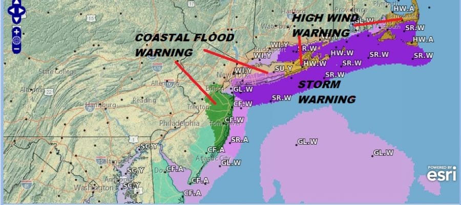
COASTAL FLOOD WARNINGS, STORM WARNINGS FOR COASTAL WATERS
WINDS WILL GUST 50-60 MPH+ COASTAL AREAS NJ LONG ISLAND
WIND ADVISORIES & HIGH WIND WARNINGS, RAIN 1 TO 2 INCHES+
Weather conditions will slowly begin to deteriorate today as high clouds begin to increase and thicken up. No rain is forecast through the evening commute but after that our storm gets underway with noreaster conditions developing overnight. Rain overspreads New Jersey later this evening and by midnight it should be raining everywhere from Eastern Pennsylvania to Southern New England. The worst of it will be Saturday morning with regards to wind with gusts of 50 mph or more up and down the coast from New Jersey to Long Island while inland gusts will reach into the 30+ mph range at times.

As to the rainfall part of this systems we are thinking that everyone gets into a 1 to 2 inch rainfall however there will be some locally higher amounts approaching 3 inches. While there are no flood watches posted I would not be at all surprised to see localized flooding in the usual suspect spots from heavy rain.

We are starting to see high clouds moving northeastward on the satellite loop this morning but it will take awhile for clouds to increase and thicken up Temperatures today will struggle back to the upper 40s and lower 50s this afternoon. Rain is on the regional radar now with a solid area of heavy rain moving through North Carolina and heading into Virginia. Rain will reach Southern New Jersey & Southeastern Pennsylvania by sundown.
EASTERN SATELLITE

REGIONAL RADAR

The worst of it will be Saturday morning with heavy rain and wind and then gradually the rain will be moving northward Saturday afternoon and evening. With low moving away to the north northeast we should see weather conditions improve Saturday night.

The push of dry air behind this is not a solid one plus we do have the next weather system swinging in from the Midwest so Sunday we will see clouds with some brightening of skies and even a break or two of sunshine but no rain is forecast. Highs will be in the 50s to near 60. Then as a low moves to the East we will likely see some rain showers late Sunday night into Monday morning as the next system goes by.
Next week will be a busy one as we have several systems in play. The one to focus the most attention on will be for next weekend with a strong front approaching the coast and low pressure moving along it. We will see some sunshine Tuesday into Thursday should be mostly dry with a chance for showers Thursday and Friday with a stalling front and rain for next weekend as a low moves up the coast.
SUBSCRIBE TO PATREON FOR A WEATHER EXPERIENCE FREE OF ADS, EXCLUSIVE VIDEOS FOR MEMBERS ONLY AND MUCH MORE…STARTS AT $2 A MONTH..MESSAGE ME AT ANY TIME

MANY THANKS TO TROPICAL TIDBITS FOR THE USE OF MAPS
Please note that with regards to any tropical storms or hurricanes, should a storm be threatening, please consult your local National Weather Service office or your local government officials about what action you should be taking to protect life and property.
LATEST JOESTRADAMUS ON THE LONG RANGE

