Nice Weather Into Saturday Before Pattern Turns Wet
Nice Weather Into Saturday Before Pattern Turns Wet
We are now past yesterday’s cold front and we can move forward with very nice weather conditions for at least the next 3 days and we may stretch it to a 4th day (Saturday) before we see the pattern turning wet. We have nice clear skies around the region this morning and this will a day of plenty of sunshine, lowering humidity, a north wind, and warm temperatures. Highs will reach the middle to upper 80s this afternoon even in coastal areas where there won’t be much of a sea breeze. Dry air extends back to the Great Lakes and a slow moving high pressure area will build in and keep us dry and comfortable right through Friday. There are no issues regarding showers or thunderstorms as the radar will effectively be silent into Saturday.
EASTERN SATELLITE
REGIONAL RADAR
Tonight we can look ahead to clear skies with lows in the 60s along the coast but many inland areas will see temperatures in the 50s and even some 40s well inland. This is another shot of nice dry air coming down out of Canada.
Thursday and Friday look like 2 great days with lots of sunshine and highs into the low and middle 80s with 70s along the coast. Starting later Friday the high begins to move offshore which means that an onshore flow starts to develop. It won’t impact us much Friday as it will still be comfortable but the humidity will come up on Saturday. We should see dry conditions Saturday into Saturday evening.
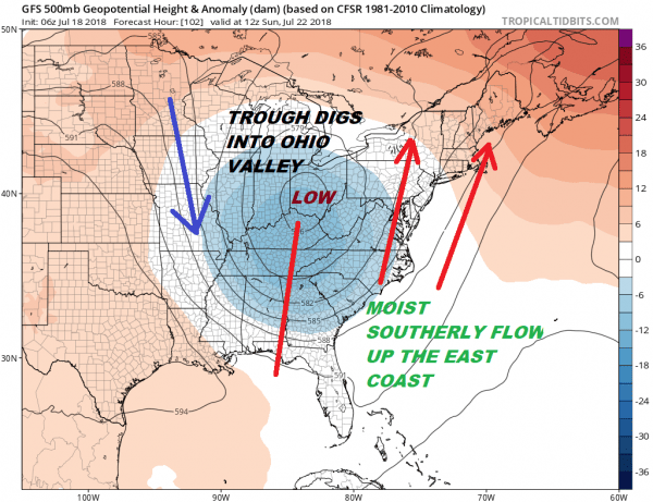
The upper air pattern will be changing drastically late this week as a trough drops into the Ohio Valley and sets up a southerly flow along the East Coast. There is nothing upstream to kick that trough out so this will put us in a moist flow for days beginning Saturday night. Low pressure will develop on a warm front off the Carolinas and move northward. It is a rather small feature here but enough to bring some rain Saturday night into early Sunday morning for coastal areas of New Jersey and Long Island to Southern New England. It might even get a bit breezy along coastal areas as the pressure gradient around the low is a bit on the tight side. I don’t believe this system has time to become tropical but we do have to watch this for a surge of heavy rain as it lifts northward.
JET STREAM SUNDAY JULY 22, 2018
This is not a jet stream pattern you want to see along the East Coast if there is a tropical system running around in the Bahamas as it would just shoot right up the coast with an upper air pattern like this. However the southerly flow is moisture rich and if this upper trough hangs around in the Ohio Valley for a few days, it will mean waves of downpours from time to time beginning Saturday night and lasting well into next week.
Please note that with regards to any tropical storms or hurricanes, should a storm be threatening, please consult your local National Weather Service office or your local government officials about what action you should be taking to protect life and property.
 GET JOE A CIGAR IF YOU LIKE
LATEST JOESTRADAMUS ON THE LONG RANGE


