Nice Start But Clouds Scattered Showers Later Today Nice Wednesday Thursday

Weather in 5/Joe & Joe Weather Show Latest Podcast
Nice Start But Clouds Scattered Showers Later Today Nice Wednesday Thursday
We cleared out nicely overnight and that has given us a nice start to this Tuesday but we do have an upper trough moving southeast from Eastern Canada that will pass through later this afternoon and this evening. This will produce clouds later today and there is the odd risk for a passing scattered shower or even what is known as a low top thunderstorm in some inland areas. Most of you won’t see see much of anything other than clouds. Temperatures today will be capped thanks to cool air over us and developing cloud cover later today. Most highs will reach into the lower 60s.
SATELLITE

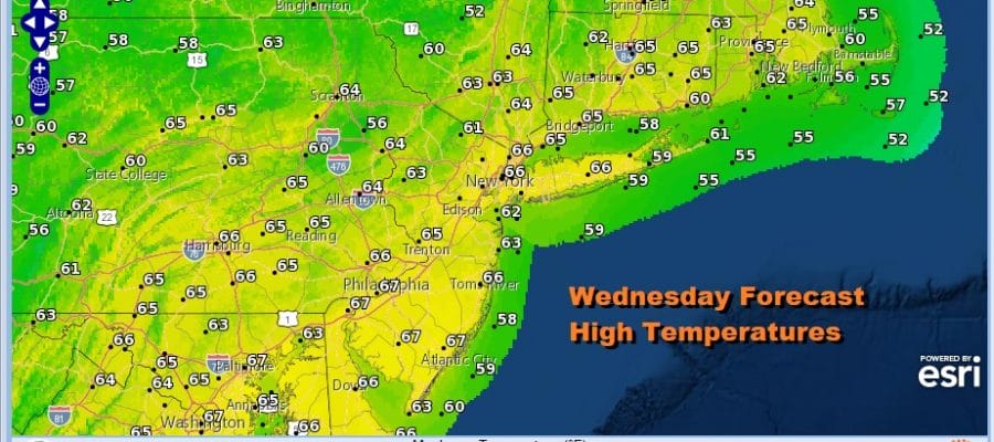
Once this upper trough passes through skies should clear out later tonight and that sets us up for the two best days of the week. Temperatures Wednesday morning will bottom in the upper 30s to mid 40s across the region from Eastern Pennsylvania to Southern New England. There should be enough of a breeze to prevent any kind of frost issues inland but we will monitor this. Wednesday will be a nice day of sunshine with a northwest breeze and just some passing clouds. Most highs will be in a range of 60 to 65.

Thursday will be a very good day indeed as high pressure builds in to the Northeast and Middle Atlantic states. We should enjoy mostly sunny skies from start to finish with no issues. Highs will be in a range of 65 to near 70 degrees in some areas. Sea breeze issues should be confined to the immediate coast.

The high will hold in for Friday and the weekend but we will still be under a northwest flow in the upper atmosphere. Little disturbances will be moving along it however they are weak. This leads me to forecast partly sunny skies for each day Friday through Sunday. Temperatures will reach the upper 60s and lower 70s each day. Each afternoon there is the chance for a scattered shower or thunderstorm mainly inland and for the most part, most of you won’t see them. Even if you do they won’t last. Is it perfect? No but given the time of year and the pattern we are in, it won’t be too bad.
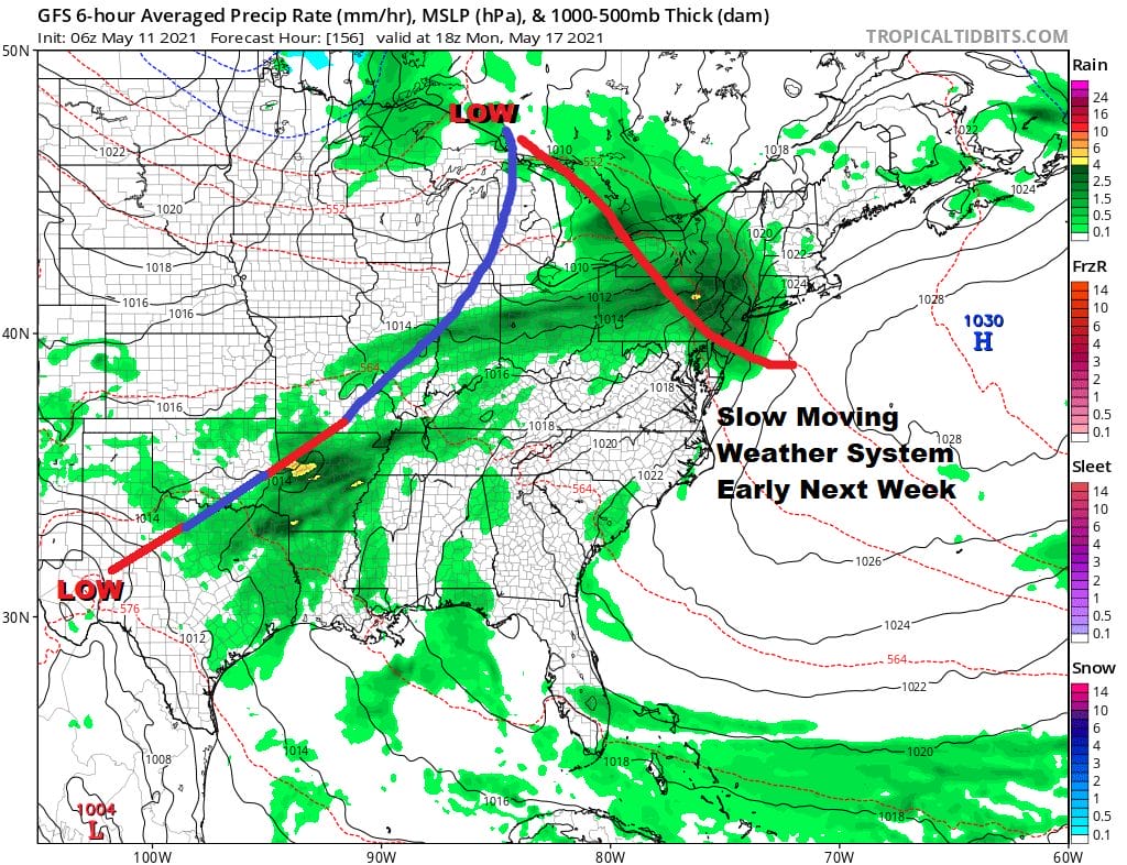
Next week starts off with a slow moving warm front cold front combination. This will bring rain or showers on Monday and then the cold front follows Tuesday with showers and the chance for thunderstorms. Once that goes by we should turn dry and cool again for later next week. We have a blocking pattern that just won’t go away and until it does, the trend is your friend and that means the cool and occasionally wet pattern we are in continues until further notice with the odd warm day here and there.

BE SURE TO DOWNLOAD THE FREE METEOROLOGIST JOE CIOFFI WEATHER APP &
ANGRY BEN’S FREE WEATHER APP “THE ANGRY WEATHERMAN!
MANY THANKS TO TROPICAL TIDBITS FOR THE USE OF MAPS
Please note that with regards to any severe weather, tropical storms, or hurricanes, should a storm be threatening, please consult your local National Weather Service office or your local government officials about what action you should be taking to protect life and property.


