
Two Best Days of the Week Friday Through Sunday Looks Decent Overall

Weather in 5/Joe & Joe Weather Show Latest Podcast
Two Best Days of the Week Friday Through Sunday Looks Decent Overall
We have finally arrived at the two best days of the week. Yesterday’s upper trough is now offshore and it is suppressing rain that is moving through the Southeast US today. Some of the high clouds from this system have made it as far north as Maryland to Southern New Jersey but those clouds are pivoting to the east thanks to the dry northwest flow aloft. In sum we should see plenty of sunshine today with temperatures topping out in the 60s with no radar issues to worry about.
SATELLITE

Tonight skies should be mostly clear with lows mostly in the 40s with a few 30s in the coldest of cold spots. Thursday is going to be a very nice day indeed and certainly the best day of the week. We will have lots of sunshine and most highs will reach the upper 60s to around 70 degrees and the sea breeze will be confined to the immediate coast.

We are also increasingly optimistic regarding Friday and the weekend. The high will remain overhead and while the northwest flow continues with weak upper air disturbances, these systems are so weak that for the most part they will produce nothing more than a few patchy clouds at times. More sun means we can nudge temperatures higher.
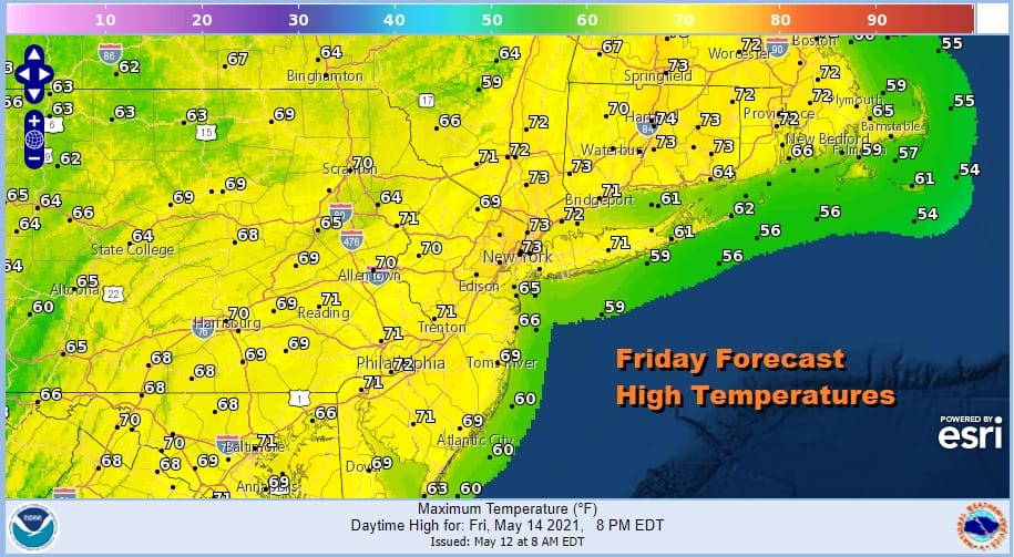
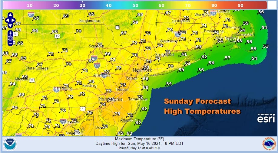
Look for Highs on Friday to reach into the 70s in many areas. Saturday and Sunday we could see highs reach 70 to 75. These forecast highs are reasonable and seasonable for sure and while in theory there is the chance for an isolated shower or thunderstorm each afternoon, the chances have decreased and I may eventually just take the idea out of the forecast.

Next week could prove interesting in that models are battling over the block to the northeast and a ridge that may try to pop up along the East Coast. The GFS favors the block holding which would mean some rain here later Monday into Monday night while the other models are for more bullish on the idea of a ridge building into the Eastern US and the nice weather continuing. It will also mean a transition to warmer than average temperatures and a mostly dry pattern for next week. We will watch the models closely on this and we should have a better handle on this in the coming days.

BE SURE TO DOWNLOAD THE FREE METEOROLOGIST JOE CIOFFI WEATHER APP &
ANGRY BEN’S FREE WEATHER APP “THE ANGRY WEATHERMAN!
MANY THANKS TO TROPICAL TIDBITS FOR THE USE OF MAPS
Please note that with regards to any severe weather, tropical storms, or hurricanes, should a storm be threatening, please consult your local National Weather Service office or your local government officials about what action you should be taking to protect life and property.


