Near Record Highs This Afternoon

Near Record Highs This Afternoon
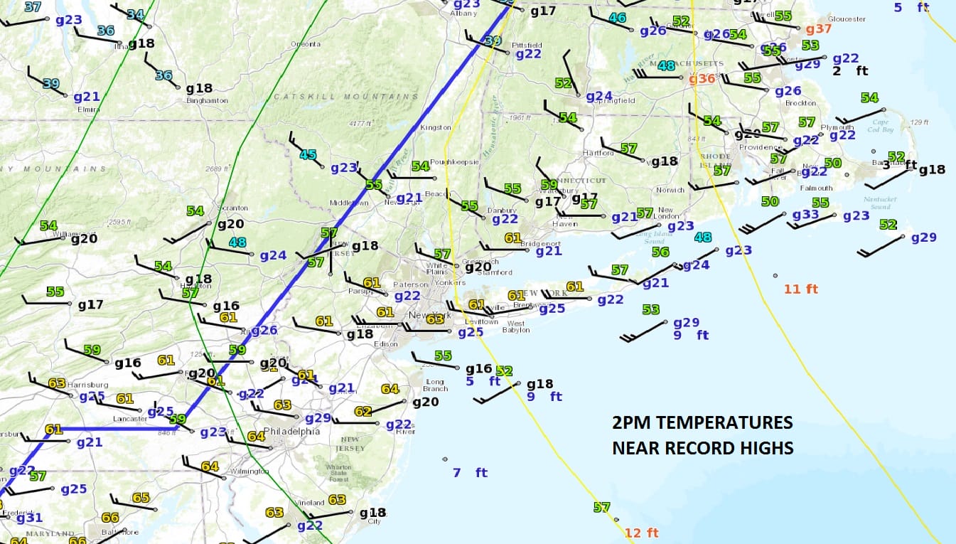
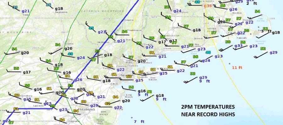
Looking at the surface map this aftenoon as of 2pm we have near record highs around the region most temperatures in the low to mid 60s! Islip tied a record high as of 2pm at 62 which was set a year ago! The surface map also shows the cold front is getting ready to move through. Behind the front temperatures are in the 30s and that air should begin moving in over the next few hours.
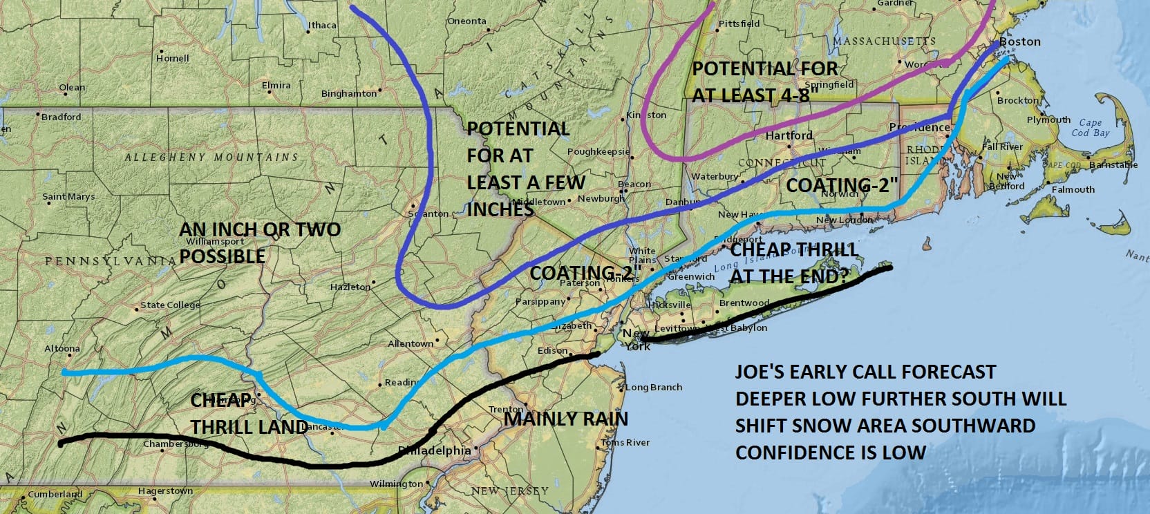
Skies will clear out tonight and Wednesday looks nice and sunny for most of the day with highs in the low to mid 40s. Clouds will arrive Wednesday night and we get set for precipitation on Thursday. Low pressure is forecast to develop off the Delaware coast and intensify rapidly as it moves northeastward. It should be cold enough in the northwestern counties of New Jersey and in the Hudson Valley along and north of Route 84 for at least a few inches of accumulation. Our early call forecast map remains unchanged as we continue to digest afternoon weather models. We will be updating this forecast if necessary later this afternoon or this evening.
For more on this forecast and other model forecasts, check the latest video.
MANY THANKS TO TROPICAL TIDBITS FOR THE WONDERFUL USE OF THE MAPS
SNOW REMOVAL COMPANIES FOR YOUR WINTER NEEDS
LONG ISLAND ROCKLAND COUNTY Connecticut

![]()


JOHNSTOWN PA
COLOSIMO LAWNCARE

FiOS1 News Weather Forecast For Long Island
FiOS1 News Weather Forecast For New Jersey
FiOS1 News Weather Forecast For Hudson Valley
NATIONAL WEATHER SERVICE SNOW FORECASTS
LATEST JOESTRADAMUS ON THE LONG RANGE
Weather App

Don’t be without Meteorologist Joe Cioffi’s weather app. It is really a meteorologist app because you get my forecasts and my analysis and not some automated computer generated forecast based on the GFS model. This is why your app forecast changes every 6 hours. It is model driven with no human input at all. It gives you an icon, a temperature and no insight whatsoever.
It is a complete weather app to suit your forecast needs. All the weather information you need is right on your phone. Android or I-phone, use it to keep track of all the latest weather information and forecasts. This weather app is also free of advertising so you don’t have to worry about security issues with your device. An accurate forecast and no worries that your device is being compromised.
Use it in conjunction with my website and my facebook and twitter and you have complete weather coverage of all the latest weather and the long range outlook. The website has been redone and upgraded. Its easy to use and everything is archived so you can see how well Joe does or doesn’t do when it comes to forecasts and outlooks.
Just click on the google play button or the apple store button on the sidebar for my app which is on My Weather Concierge. Download the app for free. Subscribe to my forecasts on an ad free environment for just 99 cents a month.
Get my forecasts in the palm of your hand for less than the cost of a cup of Joe!
![]()


