Nate Rains Arrive Monday Weekend Warm
Nate Rains Arrive Monday Weekend Warm
...AIR FORCE RESERVE AND NOAA HURRICANE HUNTER AIRCRAFT CURRENTLY
INVESTIGATING NATE OVER THE NORTHWESTERN CARIBBEAN SEA…
SUMMARY OF 700 AM CDT…1200 UTC…INFORMATION
———————————————-
LOCATION…17.8N 84.8W
ABOUT 115 MI…185 KM NE OF ISLA GUANAJA HONDURAS
ABOUT 230 MI…370 KM SSE OF COZUMEL MEXICO
MAXIMUM SUSTAINED WINDS…45 MPH…75 KM/H
PRESENT MOVEMENT…NNW OR 340 DEGREES AT 14 MPH…22 KM/H
MINIMUM CENTRAL PRESSURE…996 MB…29.41 INCHES
WATCHES AND WARNINGS
——————–
CHANGES WITH THIS ADVISORY:
None.
SUMMARY OF WATCHES AND WARNINGS IN EFFECT:
A Tropical Storm Warning is in effect for…
* Punta Castilla Honduras to the Honduras/Nicaragua border
* Punta Herrero to Rio Lagartos Mexico
A Storm Surge Watch is in effect for…
* Morgan City Louisiana to the Alabama/Florida border
* Northern and western shores of Lake Pontchartrain
A Hurricane Watch is in effect for…
* Morgan City Louisiana to the Mississippi/Alabama border
* Metropolitan New Orleans
* Lake Pontchartrain and Lake Maurepas
* Punta Herrero to Rio Lagartos Mexico
We will have more on Tropical Storm Nate and its impact on the Gulf Coast later today. In the meanimte for us some showers moved through overnight but they didn’t amount to much. Now they are gone we are going to see some sun break through the cloud cover. However there are more clouds out to the west and north and this will be the one issue over the weekend. We are going to be in a warm stagnant and somewhat humid air mass and that will mean low clouds and fog will develop during the nighttime hours and then burn off during the morning. The next 3 days will feature clouds and some sun with temperatures reaching the upper 70s and lower 80s.
SATELLITE LOOP
REGIONAL RADAR
Radars are showing showers well up to the northwest in upstate NY which is where they will stay today. Otherwise we are seeing a few scattered light showers and much of that activity isn’t reaching the ground.
LOCAL RADAR NEW YORK CITY
LOCAL RADAR PHILADELPHIA

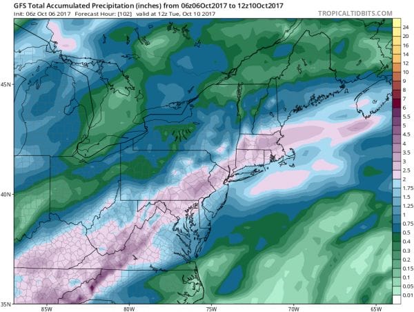
NATE’S RAINS ARRIVE MONDAY
We will be watching Tropical Storm Nate and its final track because this will be the determining factor regarding how much rain we get from this. Overnight weather models with Nate have trended a bit to the east as has the GFS. The track of the remnant low of Nate would be along or just west of the Appalachians and that should mean a widespread rainfall for somebody though there will at some point be a sharp cutoff.
NATE RAINS GFS MODEL FORECAST
The GFS model is pushing the idea of a 1 to 3 inch rainfall for the area but all this will hinge on how much of an intact post tropical low we have left once Nate moves inland. I certainly can see how this is possible but I can also see this being much further northwest like the Nam model indicates. At the very least we should get some rain out of this and considering how dry it has been, some rain is better than no rain. Nate rains should be done early Tuesday but then another front swings in from the west with the chance for some rain or showers on Wednesday.
 GET JOE A CIGAR IF YOU LIKE
FiOS1 News Weather Forecast For Long Island
FiOS1 News Weather Forecast For New Jersey
FiOS1 News Weather Forecast For Hudson Valley


