
Moving Toward Thanksgiving With No Storms
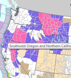
Last year at this time we were dealing with winter storm warnings up and down the interior northeast and mid Atlantic states with an inland storm that came just in time for the Thanksgiving travel day. No such storm in the cards for this Thanksgiving. It is an easy trip no matter where you are headed east of the Rockies. It is quiet. No big storms anywhere in the United States though Winter Storm Warnings are up much of the west including western parts of California and Oregon as well as much of Montana. You can click on the pic to take you to the National Weather Service home page for more information.
If you are staying home or just going nearby in our own area, no issues. Temperatures will be cold tonight though under a clear sky with light winds. Most lows will be in the 20s to near 30..except middle 30s warmer urban areas. Wednesday looks like a very good day with sunshine much of the day and temperatures rising back into the 50s..but mainly under 55. Thanksgiving day itself might have some cloud issues thanks to an onshore flow that will develop Wednesday night with the high moving out to the east. I’m thinking clouds will be around Thursday and while a spot shower is possible, I didn’t think it was worth including in the forecast.
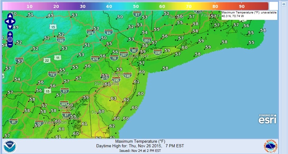

Thursday and Friday’s high temperature maps are above. Friday looks to be the warmest day this week ahead of the next cold front with highs mostly in the 60s with clouds and some sun. Friday night into Saturday the next cold front moves through but I’m thinking here that other than a passing shower or two, it will come through without much fanfare. Colder Saturday and Sunday with clouds and some sun. Models want to bring rain back here as early as Sunday afternoon on the GFS model and Sunday night into Monday on the European. I think the high building in should keep any rain out for the daytime Sunday. At least that’s the way it looks right now. Travel safely please to your Thanksgiving destination.