
Snow Lovers Will Love This
Snow in November and early December are rare occurances along the immediate east coast. That is just the way it works. I know snow lovers are already worried about the winter and it is barely Thanksgiving. They are fretting about El Nino & the North Atlantic Oscillation (among other things). Since six of the last seven winters have been snowier than normal, something which has not occured in New York City since the 1880s, a sub part winter from a snowfall standpoint would not be unusual. In fact looking at long term snow stats there are more sub par winters then there are above normal winters.
In spite of all this we are dealing with an unusual set of circumstances which I outlined in my own winter forecast which called for a winter of much more variability than the last 2.My conclusion was when it is all set and done it could turn out to be statistically closer to normal. Which ever way it goes I have also made numerous posts about the Siberian Cover index which upon its final reading is bullish on the winter. Dr Judah Cohen is the driver of this theory and below is his winter forecast map for temperatures.

Dr Cohen is calling for a back loaded winter. He is forecasting the polar vortex to split bringing the North Atlantic Oscillation into play. This was what he predicted last year which never happened. However the atmosphere had other plans as we know and it figured out a different way to deliver cold and snow. The map shows what he expects average temperatures to be for the entire winter. If this is a back loaded winter where the first half is normal or above normal, then then second half according to him will be fierce in order to achieve the temperature anomiles he is forecasting. For example, if say the first half of the winter is warmer than normal by say 3 degrees, and he is forecasting the entire winter to finish 2 degree below average, then the second half of the winter will need to be 5 degrees below average to get his numbers, That’s a tall order but we saw the same sort of thing happen last year.
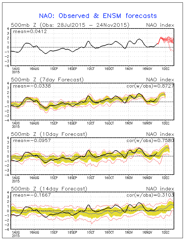
With regards to the shorter term, above is the forecast for the NAO index into mid December and it is forecast to be strongly positive meaning that there will be no blocking to deliver cold air. Conflicting with this is the Pacific North America pattern index or PNA which is turning postive. A positive PNA means a colder pattern over North America.

This would suggest intrusions of colder air that don’t hang around for more than a few days. On top of this we will a strong El Nino that continues and perhaps this is what is trumping the PNA index. The recent trend to closer to normal temperatures might be driving this for the next few weeks with the El Nino continuing to flex its muscles. We will have to wait to see a true weakening trend in the El Nino in the eastern Pacific in order to perhaps change the profile in the east. The appearance of the split flow at least suggests that the subtropical jet continues to strengthen and it will begin to deliver stronger weather systems from the Pacific into the Southern half of the United States. The question for the next few weeks is whether one of these systems can time itself together with one of those transitory cold air masses.
In summary, it is way to too early to get a sense of what the winter is really going to be like. In spite of the pattern the midwest managed an interesting 12 inch plus early snowstorm last weekend. All of this is food for thought as we head into December. If it wants to snow, it will find a way. You can read Dr Judah Cohen’s blog which he updates weekly.
SHORT TERM FORECAST FOR THANKSGIVING