More Rain Tonight Into Sunday Colder Air Arrives Sunday Night Monday
Week Ahead Offers Snow Chance

Weather in 5/Joe & Joe Weather Show Latest Podcast
More Rain Tonight Into Sunday Colder Air Arrives Sunday Night Monday
Week Ahead Offers Snow Chance
You could not have asked for a worse day for the first day of 2022 but we are simply picking up where we left off from last year. It has been raining most of the day and the radar continues to show more rain to the west that is headed here for tonight into Sunday morning. Temperatures are in the warm 50s. Our Southern Plains storm is moving northeast through the Ohio Valley and it is producing widespread severe weather across the Tennessee Valley and Deep South with heavy rains in the Ohio Valley and snow with winter storm warnings from Kansas to the Great Lakes.
SATELLITE

WEATHER RADAR

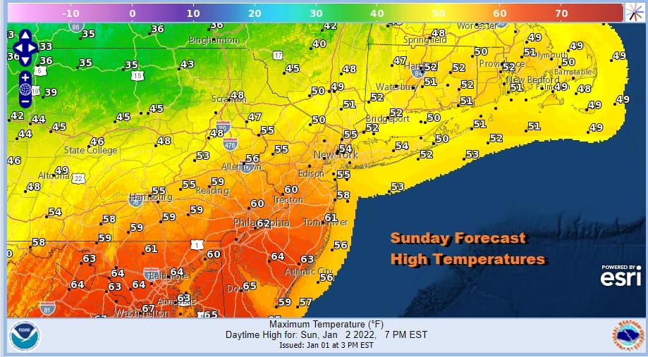
Tonight’s additional rain will hold temperatures up in the upper 40s to middle 50s. Sunday there will still be some on and off rain, more off than on. The first low will be to our east by afternoon and a cold front will have passed through and moved southward. Temperatures though will be in the mid 50s to lower 60s before the front passes through.
A second wave of low pressure develops on the front and passes to our southeast Sunday night and early Monday. This will usher in the cold air as the low intensifies and goes by however it is a long way to travel from 60 to 30 degrees. I also continue to be skeptical of light snow on the northwest side of this low. No other model brings precipitation close and even the GFS shows little if any measurable from this so we will just mention some showers Sunday night and maybe a few snowflakes in the mix. Monday morning lows will be in the 20s to around 30s.
We haven’t seen sunshine around here in well over a week as we have been sitting in this doom and gloom type pattern. Monday we will have sunshine however and it will be breezy and cold with highs just in the low to mid 30s and then down into the 20s at night. Tuesday we will be a shade warmer, mid to upper 30s and the same holds for Wednesday with sunshine on Tuesday and arriving clouds Wednesday. We have another cold front coming Wednesday night with one or two rain showers and then it turns colder again Thursday into Friday.
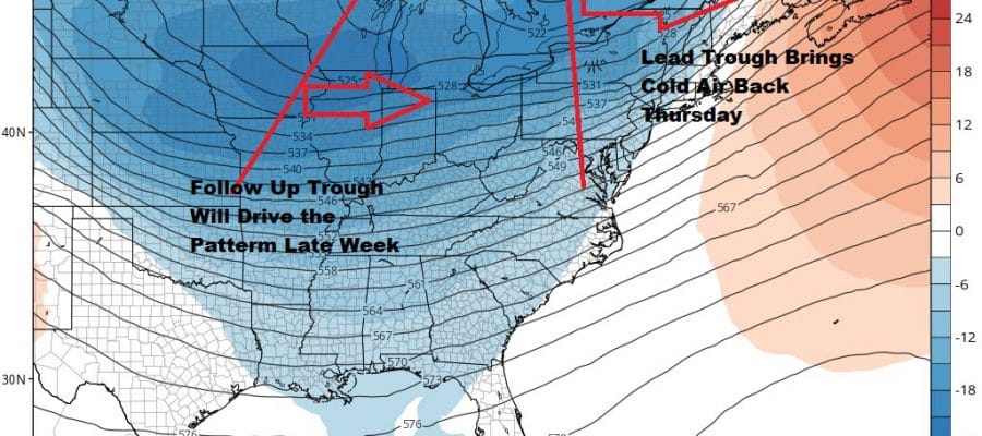
The pattern is changing this week to a colder one overall and after Thursday’s front passes early it stalls. Energy from a second Great Lakes trough will force a low to develop to the south of us and head northeast. If this materializes this would be an accumulating snow situation for Coastal I-95 as well as areas north and west. This would be for Thursday night into Friday. morning with temperatures in the 20s to lower 30s. Right now it is something to watch but the evolving pattern is more favorable that what it has been in December. This could yield some fruit for snow lovers.
BE SURE TO DOWNLOAD THE FREE METEOROLOGIST JOE CIOFFI WEATHER APP &
ANGRY BEN’S FREE WEATHER APP “THE ANGRY WEATHERMAN!

MANY THANKS TO TROPICAL TIDBITS & F5 WEATHER FOR THE USE OF MAPS
Please note that with regards to any severe weather, tropical storms, or hurricanes, should a storm be threatening, please consult your local National Weather Service office or your local government officials about what action you should be taking to protect life and property.


