More Clouds Less Heat Scattered Thunderstorms Watching Carolinas For End of Week Rain
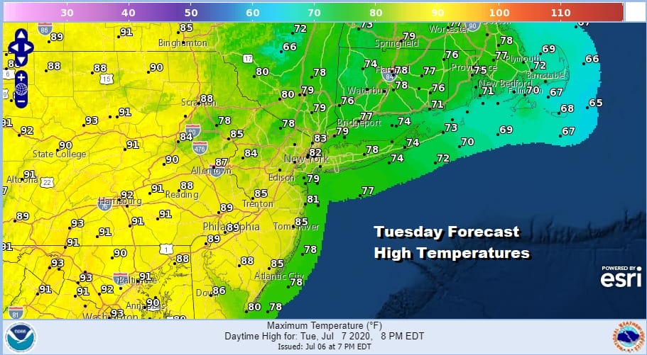
We are going to get a small break in the heat and humidity today but we do mean small. Humidity levels will still be somewhat high but temperatures will be a little lower today with most highs in the low to mid 80s. This lowering of the daytime heating will probably prevent us from getting a widespread outbreak of thunderstorms but some scattered thunderstorms are possible this afternoon and evening. Otherwise it will be a day of clouds with some sunshine breaking through. The break is a short one as temperatures are forecast to move higher again on Wednesday.
SATELLITE

REGIONAL RADAR

Radars are starting the day quietly as they usually do in the summer time. Scattered storms will pop up later today but the Storm Prediction Center does not have our area at risk for severe weather.
LOCAL RADAR NEW YORK CITY

LOCAL RADAR PHILADELPHIA


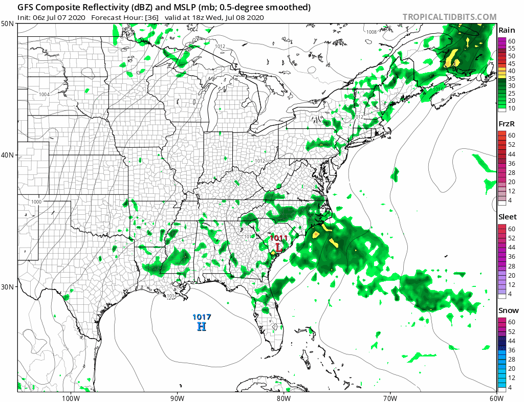
Given the fact that we will have more cloud issues today to deal with, temperatures will likely only make it to the lower and middle 80s for highs with 70s along the immediate shore. Wednesday we go back to very warm/hot and humid conditions with some sunshine and again the chance for perhaps a pop up shower or thunderstorm. Highs will be in the mid 80s to around or just over 90 degrees.

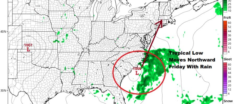
Beginning Thursday our attention turns to low pressure which is now in East Central, Georgia and will then reform along or just off the South Carolina coast during Thursday and then it heads northward up the coast.
The question for this developing low will be whether the low is far enough offshore to interact with warm subtropical waters off the Southeast coast and develop into a tropical depression or a tropical storm. Whether it does or it doesn’t it still means we could see increasing clouds on Thursday with most highs in the 80s to near 90 in some places. Then we get into some rain Friday as the low moves northward. Perhaps there could be even a bit of wind around the low center. The tropical designation if it comes is more of a technical one and would not change anything. You wouldn’t be able to tell the difference one way or the other. Much of the area has seen dry conditions alleviated over the last week to 10 days thanks to thunderstorms. The National Hurricane Center is holding on to a 40 percent chance this develops into a tropical system over the next 5 days.
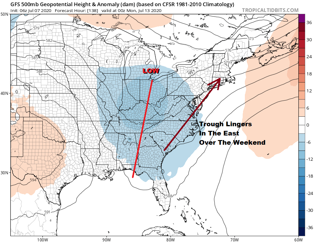
With the weekend may come some issues due to the fact that we will have an upper trough lingering in the Eastern US into early next week. This creates a south southwest flow up the coast and that means little short waves will likely be moving along it. This could certainly put is in clouds over the weekend. Whether it means some showers or rounds of rain will depend on the strength of any individual short wave rotating around the trough. I suspect that while the risk for showers will be there through the weekend and into early next week, there will also be dry periods where not much happens. We can zero in on this tomorrow or Thursday. Deeper into the long range once that trough lifts out it could open the door for a stretch of heat and humidity around mid month.
BE SURE TO DOWNLOAD THE FREE METEOROLOGIST JOE CIOFFI WEATHER APP &
ANGRY BEN’S FREE WEATHER APP “THE ANGRY WEATHERMAN!
MANY THANKS TO TROPICAL TIDBITS FOR THE USE OF MAPS
Please note that with regards to any severe weather, tropical storms, or hurricanes, should a storm be threatening, please consult your local National Weather Service office or your local government officials about what action you should be taking to protect life and property.


