
Monday Sees Shower Thunderstorm Chance Late Tuesday Best Day of the Week

Weather in 5/Joe & Joe Weather Show Latest Podcast
Monday Sees Shower Thunderstorm Chance Late Tuesday Best Day of the Week
Clouds have managed to roll in during the afternoon and evening. There were even a few spotty sprinkles around today. We will probably see these clouds hang around tonight. We did manage to break 60 in most places today. With clouds hanging around tonight most lows will be in the 40s.
SATELLITE

Another weak upper trough is going to approach and move through Monday. We should see partly sunny skies during the morning before the trough nears. We have also had to throw in the chance for a shower or a thunderstorm in the late afternoon and evening. Highs will reach the low to mid 60s.
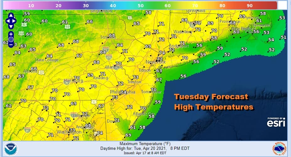
Tuesday still will be the best day of the week. Southwest winds and sunshine should take temperatures up into the 70s without too much difficulty. Depending on how much sun and we could push the highs a few degrees above the current forecast.

Wednesday sees a strong cold front that will approach and move through late in the day. The Storm Prediction Center does not have any severe weather in their Day 4 forecast but we do have a sharp upper trough with a strong southwest jet overhead late Wednesday afternoon along with strong lift in the atmosphere so I believe there is a chance we could see SPC put the area in a marginal risk for severe weather. Wind gusts will likely be the issue here. Highs Wednesday will be in the 60s before the front passes.
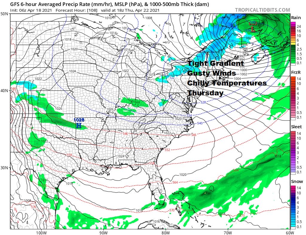
Another shot of cold air or at least cold for this time of year arrives Thursday on the backside of this front. Low pressure will strengthen in Eastern Canada and the pressure gradient will tighten up. Look for windy conditions Thursday with clouds and some sun. Highs will only be in the low to mid 50s. Winds could gust to 30 to 40 mph at times making it feel colder. For now we see this as being just below wind advisory criteria. Friday will still be on the windy side with some sunshine. Highs could make back into the 60s. Models are in disagreement for next weekend. The European once again argues for a nor’easter with rain raw and windy conditions while the GFS shows a cold front passing first and a low in the longer range sometime early next week. This will hinge on which model has a better handle on the southern part of the jet stream which the European showing more strength and getting to the East Coast faster than the GFS. This will be our weather dilemma for the coming week.

BE SURE TO DOWNLOAD THE FREE METEOROLOGIST JOE CIOFFI WEATHER APP &
ANGRY BEN’S FREE WEATHER APP “THE ANGRY WEATHERMAN!
MANY THANKS TO TROPICAL TIDBITS FOR THE USE OF MAPS
Please note that with regards to any severe weather, tropical storms, or hurricanes, should a storm be threatening, please consult your local National Weather Service office or your local government officials about what action you should be taking to protect life and property.


