
Better Day Warmer Temperatures Next Few Days
Showers Thunderstorm Possible Wednesday

Weather in 5/Joe & Joe Weather Show Latest Podcast
Better Day Warmer Temperatures Next Few Days
Showers Thunderstorm Possible Wednesday
The old coastal storm east of New England is still visible on the upper right of the satellite picture but it continues to move slowly eastward. This will allow for fewer clouds and more sunshine than yesterday. Radars are quiet in the Northeast today. A weak upper trough might produce an isolated showers well to the north and west of us. Given all this we should see enough sunshine today to reflexively push temperatures up into the low and middle 60s.
SATELLITE

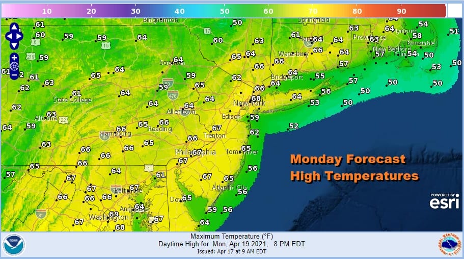
Monday into Wednesday temperatures will be on the upswing. The flow of warmer air is not overwhelming however but we are at a time of year where average highs are in the middle 60s and we should get there on Monday or perhaps a little higher than advertised. We should see a fair amount of sunshine to do the trick. A few places should be able to push over 70 degrees.
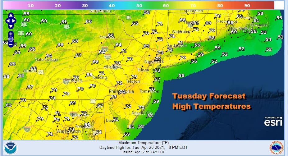
Tuesday looks to be the warmest day this week coupled again with some sunshine. Temperatures should be able to reach the low and even a few middle 70s and again I am going higher than model forecasts given the time of year.
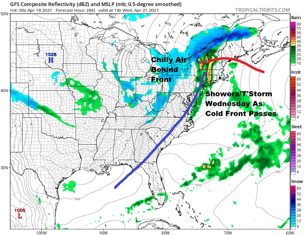
Wednesday we see the next round of changes with showers and perhaps a thunderstorm or two as a cold front passes along with a strong upper trough. Highs Wednesday will be in the 60s. Behind the front (which keeps on moving) will be another chilly air mass from Canada that drops southeastward into the Eastern US.
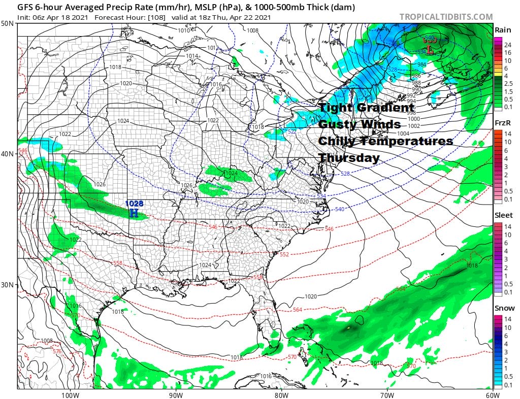
The low in Vermont strengthens into a strong storm in Eastern Canada. Coupled with the high to the west and we have a tight pressure gradient which means winds will be strong and gusty at times 20 to 35 mph. Coupled with temperatures only in the 50s and we have the makings of another chilly reminder that spring can be cruel at times. Even the lake effect snow machine will be working in upstate NY! We should see a mix of sun and clouds in this scenario.
Friday will still be on the windy side but we should see enough sun to take temperatures up into the 60s. Another cold front approaches next weekend with the chance for showers as weather systems continue their endless march across the Eastern US.
BE SURE TO DOWNLOAD THE FREE METEOROLOGIST JOE CIOFFI WEATHER APP &
ANGRY BEN’S FREE WEATHER APP “THE ANGRY WEATHERMAN!
MANY THANKS TO TROPICAL TIDBITS FOR THE USE OF MAPS
Please note that with regards to any severe weather, tropical storms, or hurricanes, should a storm be threatening, please consult your local National Weather Service office or your local government officials about what action you should be taking to protect life and property.


