Mini Heatwave Develops Northeast Mid Atlantic Mid & Late Week
With Oppressive Humidity

Mini Heatwave Develops Northeast Mid Atlantic Mid & Late Week
Oppressive Humidity & Thunderstorm Risk

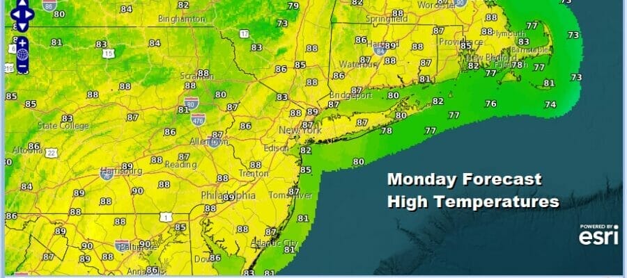
The next 10 days or so represent the time of year where the average temperatures are the highest. For Eastern Pennsylvania to Southern New England the average highs at the peak of the summer are middle to upper 80s and low in the upper 60s and lower 70s. We are going to be above those averages this week. Today we have what is left of low humidity from the weekend. This is going to gradually give way to rising dew points today. To the south across the Coastal Mid Atlantic from Delmarva and Maryland southward we have some showers and thunderstorms on the radar this morning.

Those storms shoudl move out this morning and we will see skies that should generally be no worse than partly sunny. Humidity goes higher and there is the chance we could see some scattered thunderstorms late today into tonight, mainly inland north and northwest of the coast. Best chances will be from Western New Jersey westward and there could be some isolated severe thunderstorms in the mix. Otherwise it will be an uneventful day with highs in the mid 80s to upper 80s.
SATELLITE WITH LIGHTNING STRIKES

WEATHER RADAR

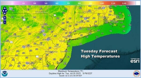
The next 5 days we will see temperatures go up and dew points go up as well. A warm humid night lies ahead with lows Tuesday morning in the upper 60s to mid 70s. Tuesday dayside we will see skies no worse than partly sunny. An upper trough will approach and that could set off scattered thunderstorms in the late afternoon and evening. Highs will be in the mid 80s to near 90 degrees.
As we move into Wednesday we will see dew points head above 70 and that should make things very uncomfortable. We will also see temperatures reach up into the 90s Wednesday through Friday. Wednesday may be a day where thunderstorms will not be an issue or at least if they do pop up they will be minimal. A very hot and very humid day is on tap with highs Wednesday reaching the low to middle 90s.

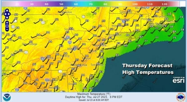
Thursday will be day 2 of this heatwave with means veryw warm humid night in the 70s for lows, except for maybe mid to upper 60s in the coolest spots. Thursday will be very hot and humid. We will throw in the chance for thunderstorms late in the day and there could be some isolated severe thunderstorms in the mix. Highs will reach the low to middle 90s.
An upper trough moves through Thursday night leaving us in the same place Friday with a west southwest wind. A cold front will approach Friday so that west wind could make Friday the hottest day of this upcoming stretch. Highs will be in the mid to a few upper 90s. Thunderstorms are likely late in the day and there could be some severe weather risk as this system passes.

I have been referring to this as a mini heat wave since it only lasts 3 days. I like the 5 days in a row definition of a heatwave and this will likley fall short of that standard. We could see showers and some thunderstorm risk over the weekend as weather fronts march through. Sunday’s weather front will likely be the humidity breaker as it has some punch to it and dry air and lower humidity could settle in to the Northeast and Mid Atlantic early next week.
BE SURE TO DOWNLOAD THE FREE METEOROLOGIST JOE CIOFFI WEATHER APP &
ANGRY BEN’S FREE WEATHER APP “THE ANGRY WEATHERMAN!
MANY THANKS TO TROPICAL TIDBITS FOR THE USE OF MAPS
Please note that with regards to any severe weather, tropical storms, or hurricanes, should a storm be threatening, please consult your local National Weather Service office or your local government officials about what action you should be taking to protect life and property.
(Amazon is an affilate of Meteorologist Joe Cioffi & earns commissions on sales.)


