
Humidity Rising Week Ahead & Heat Arrives Midweek,
Thunderstorms Rain Take A Break

Humidity Rising Week Ahead & Heat Arrives Midweek,
Thunderstorms Rain Take A Break
Our low humidity sunny weekend continues today in the Northeast and Northern Mid Atlantic states capping off a lovely weekend. The satellite shows cloud free skies for the most part and the radars are nice and quiet and should remain so today. Scattered thunderstorms are limited to areas in the interior Mid Atlantic. Eastern Pennsylvania to Southern New England should have sunny skies. It will be warm with highs reaching the middle to upper 80s. This is about normal for this time of year. Temperatures will be a little cooler at the shore with loca sea breezes. Dew points will be mostly in the 50s today.It doesn’t get much better this time of year nor does it last and this air mass will not last.
SATELLITE WITH LIGHTNING STRIKES

WEATHER RADAR

The number of 90 degree days so far this summer have been few and far between in the Northeast but that is likely to change later this week. We have a temporary break in the pattern of cold fronts moving through every couple of days. This means that the atmosphere will have a chance to heat up. It also means that thunderstorm activity will be minimal during this week which is change from from the pattern that produced widespread thunderstorms, severe weather and flash flooding.

High pressure settles offshore and we start to get into a west to west southwest flow. Temperatures will begin to rise, and humidity will begin to rise as well. It doesn’t come all at once though with the increase being more gradual. Dew points will start to come up a bit Monday but not o oppressive levels. We should see sunshine for much of the day.

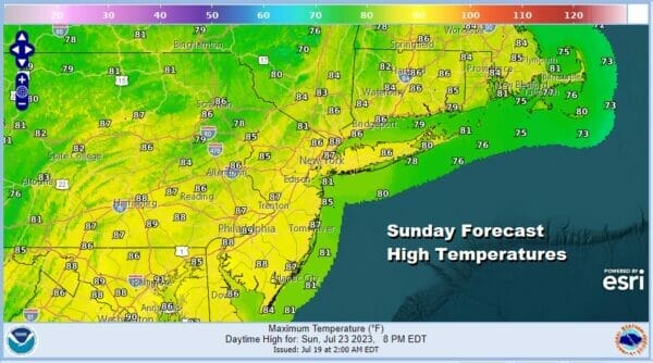
We will throw in the chance for a scattered thunderstorm Monday afternoon and evening with the best chances inland and the least chances along the coast. Highs Monday will be in the mid to upper 80s. The rise in dew points continues Tuesday when it starts to get uncomfortable. Tuesday will be much like Monday with partly sunny skies with very warm conditions and the chance for scattered thunderstorms. Highs again will be in the mid to upper 80s.
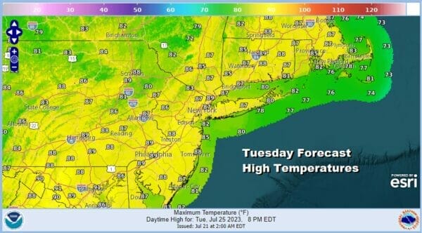
Wednesday is going to be the first day of temperatures in the 90s and it appears we have a 3 day streak of 90 degree highs to look ahead to. Humidity levels are going to climb to oppressive levels as dew points rise into the 70s and pretty much stay there through the rest of the week.

Skies should be no wose than partly sunny and there is the outside chance for a scattered inland shower or thunderstorm. Then the heat gets turned up for Thursday an Friday as winds turn more westerly and that allows temperatures to soar. Skywise Thursday and Friday will be no worse than partly sunny and both days will be very hot and very humid. Highs will reach the low to mid 90s and some hot spots could see upper 90s especially Friday.
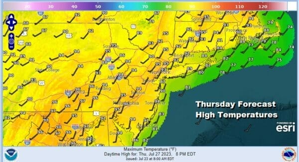

Late day scattered thunderstorms are possible Thursday and Friday. The chances are probably higher late Friday as a cold front drops southeastward from Upstate NY. The front will struggle southward leaving us with perhaps one more 90 degree high day Saturday, though temperatures will come off the highs of Friday. Also we could see the risk for thunderstorms increase Saturday with a slow moving front and the chance that there could be a wave along that frontal boundary. This will be a 3 to perhaps 4 day heatwave but is not likely to go much beyond 4 days.
BE SURE TO DOWNLOAD THE FREE METEOROLOGIST JOE CIOFFI WEATHER APP &
ANGRY BEN’S FREE WEATHER APP “THE ANGRY WEATHERMAN!
MANY THANKS TO TROPICAL TIDBITS FOR THE USE OF MAPS
Please note that with regards to any severe weather, tropical storms, or hurricanes, should a storm be threatening, please consult your local National Weather Service office or your local government officials about what action you should be taking to protect life and property.
(Amazon is an affilate of Meteorologist Joe Cioffi & earns commissions on sales.)


