Maria Turns North North East As Cold Front Nears
SHOP THE JOESTRADAMUS STORE

Maria Turns North North East As Cold Front Nears
While the heat goes on for one last day we can see the cold front crossing the Eastern Lakes while Hurricane Maria which became a hurricane again, is finally moving north northeast though at a snails pace at the moment. In the meantime it was another summery day through most of the area. Even coastal areas with a northeast wind managed to make it into the 80s with a scattering of record highs again. The front comes through tonight with minimal weather with it. Maria will begin to edge to the northeast and then start its move out to sea on Thursday.
SATELLITE LOOP

REGIONAL RADAR

Some of Maria’s outer rain bands are showing up on the local and regional radars this evening but they will all remain offshore. Showers with the cold front are well north and west and will have no bearing here on our weather overnight.
LOCAL RADAR NEW YORK CITY

LOCAL RADAR PHILADELPHIA


The humidity levels will drop off on Thursday though the temperatures will be in the 70s to near 80. At least it will feel more comfortable.
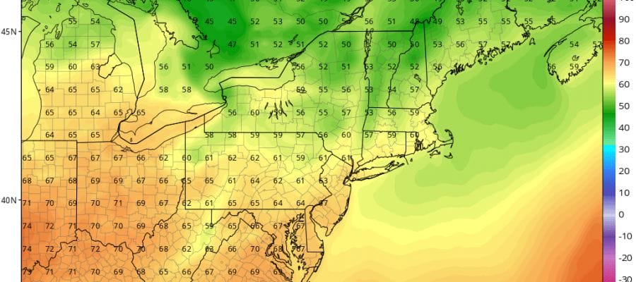
NAM MODEL 2PM TEMPERATURES FRIDAY

Friday we turn cooler with sun and clouds with highs in the low to mid 70s. Then another front comes through Friday night with a few passing showers possible but again it won’t amount to much. Saturday and Sunday we will see sunshine and cool conditions both days with highs mostly in the 60s.
 GET JOE A CIGAR IF YOU LIKE

FiOS1 News Weather Forecast For Long Island
FiOS1 News Weather Forecast For New Jersey
FiOS1 News Weather Forecast For Hudson Valley


