Maria Moving NNW Outlook Weather Models
Maria Moving NNW Outlook Weather Models
2PM NATIONAL HURRICANE CENTER ADVISORY
…MARIA NOW MOVING NORTH-NORTHWESTWARD, AWAY FROM THE TURKS AND
CAICOS ISLANDS…
SUMMARY OF 200 PM EDT…1800 UTC…INFORMATION
———————————————-
LOCATION…22.8N 71.2W
ABOUT 90 MI…145 KM N OF GRAND TURK ISLAND
ABOUT 420 MI…675 KM ESE OF NASSAU
MAXIMUM SUSTAINED WINDS…125 MPH…205 KM/H
PRESENT MOVEMENT…NNW OR 330 DEGREES AT 9 MPH…15 KM/H
MINIMUM CENTRAL PRESSURE…959 MB…28.32 INCHES
WATCHES AND WARNINGS
——————–
CHANGES WITH THIS ADVISORY:
None.
SUMMARY OF WATCHES AND WARNINGS IN EFFECT:
A Hurricane Warning is in effect for…
* Turks and Caicos Islands and the Southeastern Bahamas
A Tropical Storm Warning is in effect for…
* Central Bahamas
A Hurricane Warning means that hurricane conditions are expected
somewhere within the warning area. Preparations to protect life and
property should be rushed to completion.
A Tropical Storm Warning means that tropical storm conditions are
expected somewhere within the warning area.
Interests elsewhere in the Bahamas should monitor the progress of
Maria.
SATELLITE LOOP

Hurricane Maria is straddling the Bahamas with the bulk of the hurricane passing to the east of the islands after making a very close pass to Turks Island earlier today. The path from here has now become somewhat uncertain and we can thank Jose for this. We have been emphasizing for several days that there were many keys to this longer term puzzle for Maria and the biggest factor was Jose. The storm is no longer tropical but the remaining low continues to drift around. The Canadian model is usually defined as a broken clock right twice a day model and apparently we are seeing it showing a faster moving Maria moving up along the east coast just offshore. The last several runs of the Canadian showed Jose getting ejected to the northeast and dissipating faster than the other models. Jose’s presence was very crucial as it created a weakness for Maria to respond to and forcing it to take an out to sea track. The out to sea track is still the strongest option on the table.

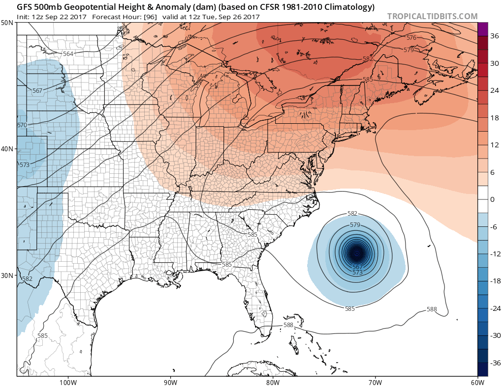
NEW GFS RUN
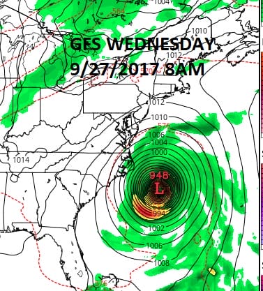
The new GFS run is almost 240 miles to the west of the overnight run and certainly suggests a closer pass to the Outer Banks of North Carolina. The European model has also shifted to the west but by a much smaller margin of less than 100 miles.
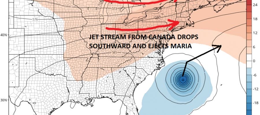
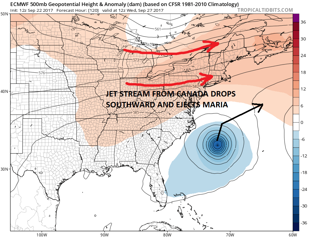
In the end Maria will still get ejected out to the northeast because the northern part of the jet stream is dropping southward which should take the storm out to the northeast once reaching the latitude of Northeast North Carolina.
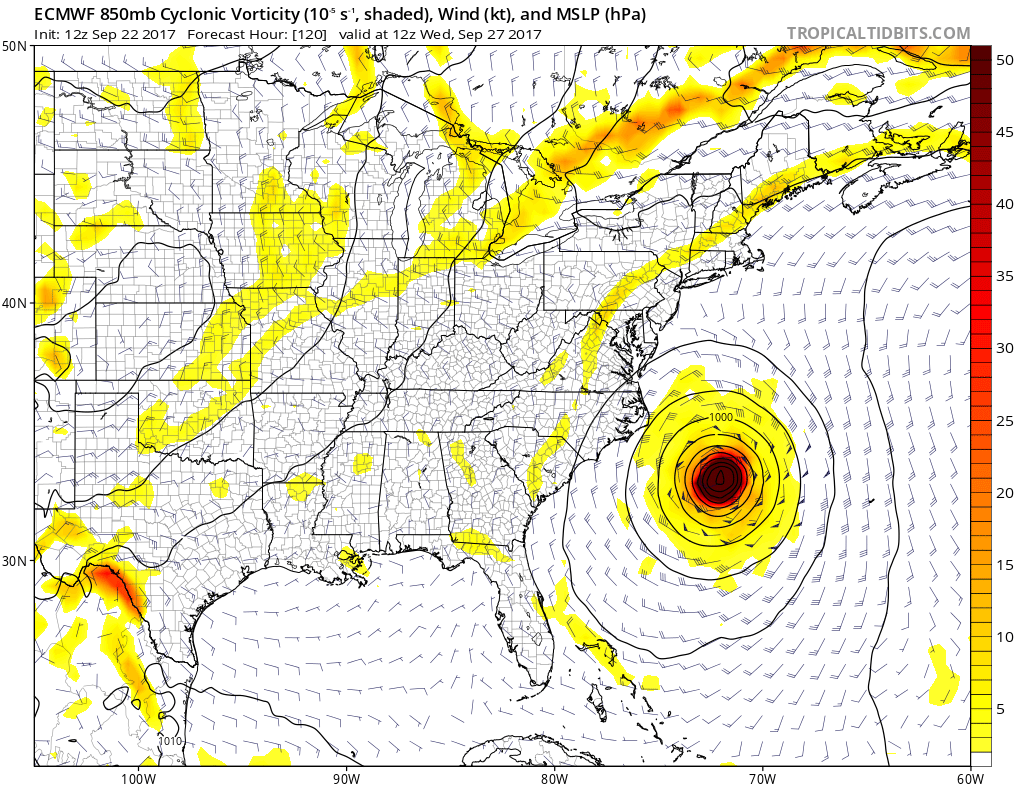
EUROPEAN MODEL WEDNESDAY SEPTEMBER 27 8AM
The GFS & European Model have basically the same timing. Maria moves northward slowly which makes sense given the absence of any kind of stronger jet stream flow to carry it northward faster. This is the other difference with the Canadian model. This model moves Maria northward faster than the other two models.

Above are the two model views for Tuesday and the Canadian at the top has already raced Maria to just off the Virginia coast. By being faster it is able to lift Maria further north before the jet stream in Canada comes down and turns it to the northeast but not before it reaches our latitude. This idea to be honest seems very unrealistic given the fact that the upper flow along the east coast is so weak. It would hard to imagine that Maria which has been crawling to the northwest would suddenly start moving at 15 or 20 mph. It would need to get far enough north faster because in the end that jet stream from Canada is going to drop southward and end our late September heat wave. For now the out to sea solution remains the course most like for Maria to take.

The hurricane tracking models have all come somewhat to the left this afternoon but not far enough left to be a concern and all the models keep Maria far enough offshore so that it is not an issue even for Coastal North Carolina.
FiOS1 News Weather Forecast For Long Island
FiOS1 News Weather Forecast For New Jersey
FiOS1 News Weather Forecast For Hudson Valley