Major Storm High Winds Heavy Rains
SHOP THE JOESTRADAMUS STORE
Major Storm High Winds Heavy Rains
FLASH FLOOD WATCH FOR EASTERN PENNSYLVANIA TO SOUTHERN NEW ENGLAND
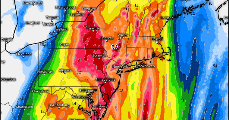
The major storm developing along the East Coast is underway with low pressure developing this morning off the South Carolina coast and heading northward. Rain is already underway. Rainfall forecast totals remain pretty much the same with most places getting 2 to 3 inches with higher amounts showing up in much of Eastern Pennsylvania.
EUROPEAN MODEL RAINFALL FORECAST
MAP COURTESY OF WEATHER.US

On the satellite loop this morning you can see the frontal boundary has now reached the East Coast. Much of the clouds are rushing up from the south. On the southern tail of this is Tropical Storm Philippe which continues to move rapidly northward and will eventually be absorbed by the developing non tropical system to the north of it.
SATELLITE LOOP

REGIONAL RADAR

Radars are loaded this morning with lots of rain and some heavier downpours and a few thunderstorms thrown into the mix as well. This is going to continue right into the evening hours for most of the area though there could be occasional gaps that develop here and there.
LOCAL RADAR NEW YORK CITY

LOCAL RADAR PHILADELPHIA


With regards to the wind that will begin to crank up this afternoon and will reach its peak during the first part of tonight. There is still some debate over which model has the best view on this so I think at this point it is probably best to say that from Coastal New Jersey to Southern New England look for winds along the coast that could gust to 40-50 mph. From NYC Long Island & Connecticut where the pressure gradient is tighter winds this evening and the first part of tonight could gust past 50 mph and in fact along the coast hurricane force gusts are not out of the question.
MAJOR STORM DEVELOPING GFS 2PM SUNDAY

Once the low goes by tonight winds will shift to the northwest and become strong and gusty into Monday afternoon. Weather conditions improve Monday with some sunshine with highs just in the 50s. Dry weather continues Tuesday & Wednesday with some sunshine and highs both days in the 50s.
 GET JOE A CIGAR IF YOU LIKE

FiOS1 News Weather Forecast For Long Island
FiOS1 News Weather Forecast For New Jersey
FiOS1 News Weather Forecast For Hudson Valley


