FLASH FLOOD WATCH HEAVY RAINS ON RADAR
FLASH FLOOD WATCH HEAVY RAINS ON RADAR
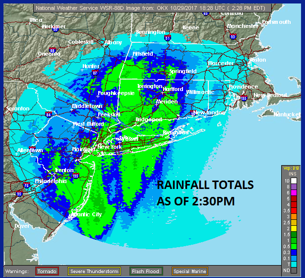
Rain continues to move northward this afternoon and there have been some heavy downpours in the mix. So far on average 1/2 inch to an inch of rain has fallen through most of the area though amounts have been a bit less to the west.
RAINFALL SO FAR DOPPLER ESTIMATES

On the satellite loop this afternoon you can see the major storm beginning to take shape along the coast as the satellite signature of a strong storm with a comma head structure continues to develop. On the southern end of the comma is Tropical Storm Philippe with 60 mph winds and racing east northeastward at almost 50 mph. Philippe will get absorbed by the non tropical cyclone to the north as the day wears on.
SATELLITE LOOP

In the meantime the radar to the south is loaded and moving northward. Bands of heavy rain will be arriving as we head into the late afternoon and evening hours.
REGIONAL RADAR

LOCAL RADAR NEW YORK CITY

LOCAL RADAR PHILADELPHIA


With respect to the wind look for the winds along the coast to begin to increase rapidly after 6pm and High Wind Warnings for Long Island Connecticut and much of the Hudson Valley remain in effect.
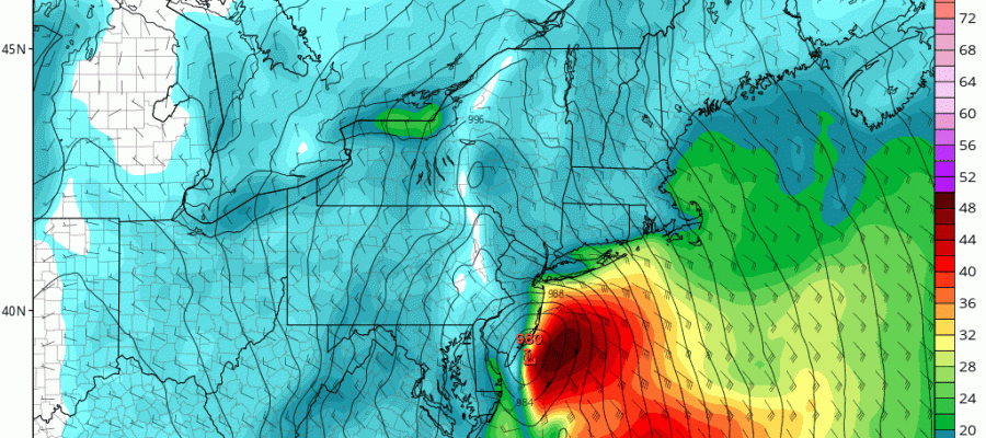
NAM MODEL WINDS 8PM SUNDAY-2PM MONDAY

The NAM model is very aggressive with its wind profile with the 35-50 knot sustained winds in red touching the New Jersey coast and then moving over Long Island and Southern New England this evening. Everything seems to be on course for a rocky evening and overnight. No changes for Monday. Rain will end during the early morning hours and Monday we will have strong gusty northwest winds up to 40 mph for large portion of the day with clouds and some sun.
 GET JOE A CIGAR IF YOU LIKE

FiOS1 News Weather Forecast For Long Island
FiOS1 News Weather Forecast For New Jersey
FiOS1 News Weather Forecast For Hudson Valley
NATIONAL WEATHER SERVICE SNOW FORECASTS
LATEST JOESTRADAMUS ON THE LONG RANGE


