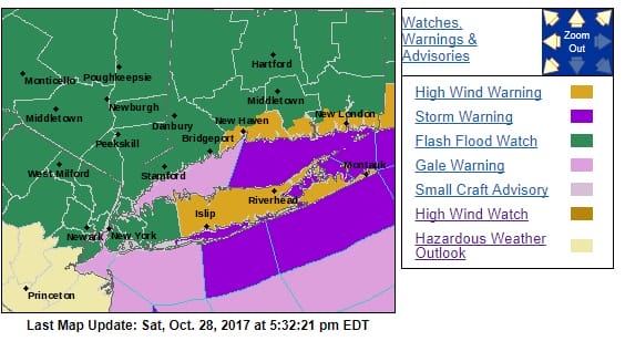
Flash Flood Watch High Wind Warning Eastern Connecticut, Long Island
SHOP THE JOESTRADAMUS STORE
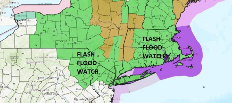
Flash Flood Watch Northern NJ, NYC, LI, Hudson Valley Ct
High Wind Warning Eastern Connecticut, Long Island

Flash Flood Watch is in effect for the counties in dark green which includes areas from Northeastern Pennsylvania to New Jersey, the Hudson Valley, New York City, Long Island & Connecticut for Sunday and Sunday night. In terms of rainfall amounts I’m thinking that if we cant average 1 to 3 inches area wide with more areas finishing on the high side of this range, they we might as well give up on rain altogether.
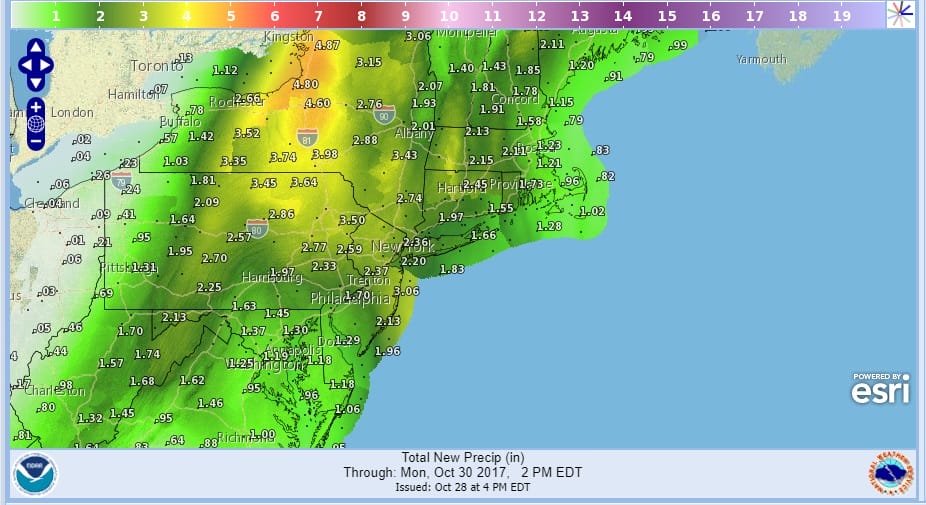
FLASH FLOOD WATCH RAINFALL FORECAST
As far as winds are concerned, a High Wind Warning is in effect for Sunday and Sunday night for Suffolk County on Long Island as well as most of Coastal Connecticut eastward. Those are the areas shaded in brown below. The wind part of this forecast is the tougher issue. Weather models are different in how they show the wind fields. The European & Nam model would have strong winds from New Jersey to Southern New England late tomorrow afternoon and tomorrow evening when the storm goes by but there is some debate on this as other models have the wind field distributed differently where there is less wind along coastal New Jersey and much stronger winds to the east.
Regardless of what happens tomorrow evening once the storm center moves into Upstate NY everyone will experience gusty northwest winds later Sunday night into Monday morning on the order of 20 to 35 knots with higher gusts. Rain should end later tomorrow evening into the early morning hours Monday from south to north.
SATELLITE LOOP

Tonight’s satellite loop shows the players all in action with a cold front swinging into the Appalachians while Tropical Storm Philippe is moving rapidly northward into the Florida Straits. Low pressure is forecast to develop off the Southeast Coast of the US Sunday morning and intensify rapidly into a major East Coast storm as it moves northward. Radar is beginning to show rain advancing eastward with a cold front into Central Pennsylvania. Those showers will make slow eastward progress overnight. Rain should overspread the area Sunday morning with some areas of heavy rain.
REGIONAL RADAR

The worst of the wind will be later Sunday afternoon into Sunday night in the areas to the east. The New Jersey shore may not fare too badly here with gales along the immediate coast. The strongest winds will be for Long Island & Coastal Connecticut through tomorrow evening. Then overnight into Monday morning they will be strong and gusty everywhere.
Weather conditions improve on Monday even though it will take most of the day for the wind to die off. Skies will clear out Monday night and Tuesday and Wednesday look nice and sunny. Temperatures Monday will be in the 50s all day. Tuesday and Wednesday highs will be in the 55 to 60 degree range. No other big storms are on the horizon for this week once this storm is done as the pattern changes.
Tropical Storm Philippe has formed and is moving rapidly northward into the Florida Straits. JOESTRADAMUS has more on Philippe and what impact if any it will have with our developing East Coast storm.
 GET JOE A CIGAR IF YOU LIKE

FiOS1 News Weather Forecast For Long Island
FiOS1 News Weather Forecast For New Jersey
FiOS1 News Weather Forecast For Hudson Valley


