Major Storm Departs Northeast New Major Storm Develops Southern Plains Easter Weekend
Timing wise we are in an okay place. A major storm is sitting in the Gulf of Maine today and we are seeing the impact here in the form of lots of clouds, gusty winds to 40 mph or more and the occasional rain and/or snow shower. Hard to believe that we are seeing snowflakes since we barely saw them this winter but such is life in the weather world sometimes. It will remain windy all afternoon. Wind Advisories remain in effect from New Jersey southward until 7pm but it is windy everywhere.
SATELLITE

REGIONAL RADAR

Clouds are all over the place on the satellite picture and we are seeing the rotation around the coastal storm and a large upper air low over the Northeast. Bands of lake effect rain and snow showers continue through the afternoon and occasionally some of those rain and snow showers are showing up on the local radars as well.
LOCAL RADAR NEW YORK CITY

LOCAL RADAR PHILADELPHIA


Temperatures this afternoon will hold mostly in the upper 40s to lower 50s. Skies should start to clear out overnight with most lows in the 30, 20s well inland. Saturday the winds will ease and we will have more in the way of sunshine. Highs will be in the 50s. This is the better of the two weekend days so enjoy it.
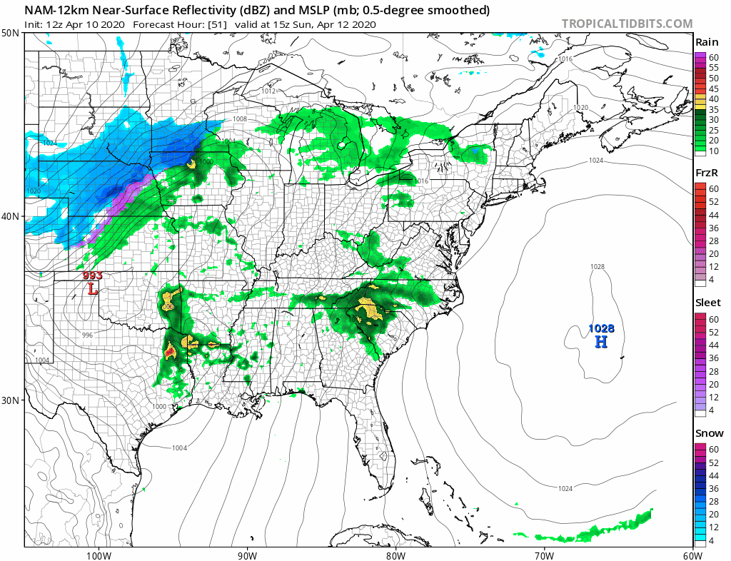
Sunday we will see lots of clouds roll in fast as a major storm develops in the Southern Plains and intensifies rapidly as it heads to the Great Lakes. This will be a storm to remember for some areas of the Eastern half of the US and Im speaking specifically to the likelihood of a major severe weather outbreak across the South.
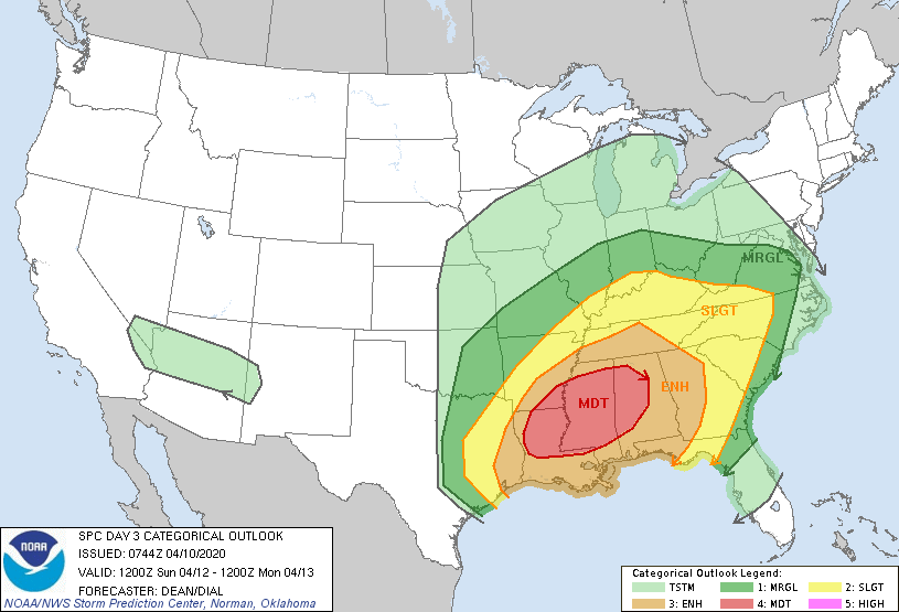
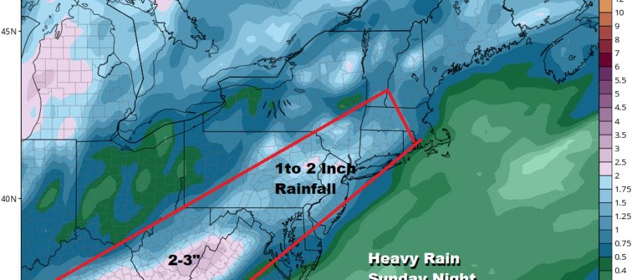
This is a very bullish Severe Weather risk call from the Storm Prediction Center 3 days in advance so it is worth paying attention to. We will see rain develop Sunday night and it will be heavy at times going into Monday morning. There could be a few thunderstorms in the mix as well
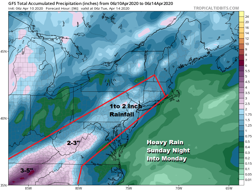
This could be a solid 1 to 2 inch rain producer area wide however the bigger deal may be the wind. Strong southerly winds will develop Sunday night into Monday and then shift to strong southwest and west once the cold front moves through. 40 to 50 mph gusts are not out of the question. This storm will also produce heavy snows in the Western Great Lakes as it moves up into Canada. Weather conditions should improve Tuesday and Wednesday though it will remain chilly for this time of year.
BE SURE TO DOWNLOAD THE FREE METEOROLOGIST JOE CIOFFI WEATHER APP &
ANGRY BEN’S FREE WEATHER APP “THE ANGRY WEATHERMAN!
MANY THANKS TO TROPICAL TIDBITS FOR THE USE OF MAPS
Please note that with regards to any severe weather, tropical storms, or hurricanes, should a storm be threatening, please consult your local National Weather Service office or your local government officials about what action you should be taking to protect life and property.


