MAJOR HURRICANE FLORENCE STRENGHENS TO CATEGORY 3
ATLANTIC SATELLITE

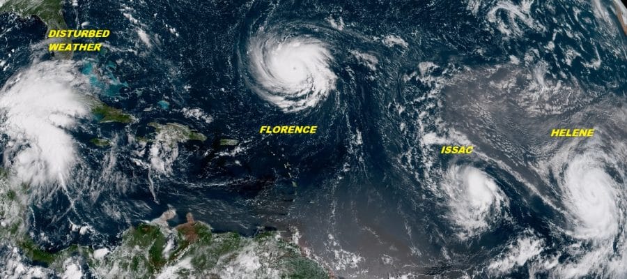
We have a beautiful satellite picture of nature’s fury with 3 hurricanes on the map with Florence in the upper center and Issac & Helene in the lower right. We also have disturbed weather in the Northwest Caribbean which looks better defined this morning. This is what an active hurricane season looks like. Florence continues to behave as forecast now undergoing rapid strengthening. Maximum sustained winds have reached 115 mph making this a category 3 hurricane. Obviously the wind shear from a few days ago did not disrupt the core of the hurricane in the least. Warm ocean water temperatures in the mid 80s and a light upper air wind environment means nothing stops this from getting to a category 4 hurricane at least.
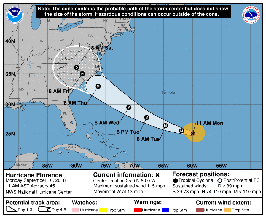
Florence has turned to the west this morning with very little northward component of motion. It is moving a little faster at 13 mph which is telling us the upper high is building and building strongly. There are no really important changes in the Hurricane Center’s forecast track going forward. We will likely see Hurricane Watches go up for the Carolinas some time on Tuesday with landfall still looking like late Thursday as a category 4 or a strong category 3 hurricane. We will take a look at the new weather models and see what they have to tell us. Look for posts later today, a live stream on Youtube at 6pm Eastern time and on Facebook with the Joe & Joe Weather Show at 9:15pm Eastern time
BULLETIN
Hurricane Florence Advisory Number 45
NWS National Hurricane Center Miami FL AL062018
1100 AM AST Mon Sep 10 2018
…FLORENCE RAPIDLY STRENGTHENS INTO A MAJOR HURRICANE…
SUMMARY OF 1100 AM AST…1500 UTC…INFORMATION
———————————————–
LOCATION…25.0N 60.0W
ABOUT 580 MI…935 KM SSE OF BERMUDA
ABOUT 1240 MI…2000 KM ESE OF CAPE FEAR NORTH CAROLINA
MAXIMUM SUSTAINED WINDS…115 MPH…185 KM/H
PRESENT MOVEMENT…W OR 280 DEGREES AT 13 MPH…20 KM/H
MINIMUM CENTRAL PRESSURE…962 MB…28.41 INCHES
WATCHES AND WARNINGS
——————–
There are no coastal watches or warnings in effect.
Interests in the southeastern and mid-Atlantic states should monitor
the progress of Florence. Storm Surge and Hurricane watches could
be issued for portions of these areas by Tuesday morning.
DISCUSSION AND OUTLOOK
———————-
At 1100 AM AST (1500 UTC), the eye of Hurricane Florence was
located near latitude 25.0 North, longitude 60.0 West. Florence is
moving toward the west near 13 mph (20 km/h). A west-northwestward
motion with an increase in forward speed is expected during the next
couple of days. A turn toward the northwest is forecast to occur
late Wednesday night. On the forecast track, the center of Florence
will move over the southwestern Atlantic Ocean between Bermuda and
the Bahamas Tuesday and Wednesday, and approach the coast of South
Carolina or North Carolina on Thursday.
Satellite data indicate that maximum sustained winds have increased
to near 115 mph (185 km/h) with higher gusts. Florence is a
category 3 hurricane on the Saffir-Simpson Hurricane Wind Scale.
Further strengthening is anticipated, and Florence is expected to be
an extremely dangerous major hurricane through Thursday.
Hurricane-force winds extend outward up to 30 miles (45 km) from the
center and tropical-storm-force winds extend outward up to 140 miles
(220 km).
The estimated minimum central pressure is 962 mb (28.41 inches).
HAZARDS AFFECTING LAND
———————-
SURF: Swells generated by Florence are affecting Bermuda and
portions of the U.S. East Coast. These swells are likely to cause
life-threatening surf and rip current conditions. Please consult
products from your local weather office.
MANY THANKS TO TROPICAL TIDBITS FOR THE USE OF MAPS
Please note that with regards to any tropical storms or hurricanes, should a storm be threatening, please consult your local National Weather Service office or your local government officials about what action you should be taking to protect life and property.
LATEST JOESTRADAMUS ON THE LONG RANGE