
MAJOR COASTAL FLOODING EVENT SETTING UP SATURDAY
Up until now we have been spending a lot of time regarding the snow and have made mention of the fact that this storm will produce major coastal flooding. It is now the time to emphasize strongly that a major coastal flooding event is likely for the New Jersey shore this weekend due to the combination of a major winter storm off the Delaware Coast. Strong northeast winds to at least gale force and probably storm force winds offshore combined with a long fetch of northeast winds and a full moon Saturday bring together all the ingredients for a major coastal flooding event. Here is the statement from the National Weather Service in Mount Holly. This could be among the top 5 worst coastal flooding events since the 1940s.
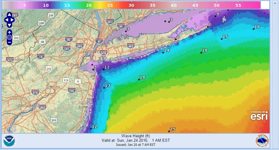
MAJOR COASTAL FLOODING NEW JERSEY COASTAL FORECAST..TIDES COULD RUN UP 2 TO 4 FEET ABOVE NORMAL ON SATURDAY
More on my Marine Forecast page including Tide widgets.
NEW VIDEO ANALYSIS OF OVERNIGHT EUROPEAN
JOESTRADAMUS Snowfall Forecast First Call
NEW VIDEO ANALYSIS OF OVERNIGHT GFS
LATEST GFS DISCUSSION REGARDING MAJOR STORM THREAT
NATIONAL WEATHER SERVICE SNOW FORECASTS
LATEST JOESTRADAMUS ON THE LONG RANGE
Weather App

Winter is here! Don’t be without Meteorologist Joe Cioffi’s weather app. It is a complete weather app to suit your forecast needs. All the weather information you need is right on your phone. Android or I-phone, use it to keep track of all the latest weather information and forecasts. This weather app is also free of advertising so you don’t have to worry about security issues with your device. An accurate forecast and no worries that your device is being compromised.
Use it in conjunction with my website and my facebook and twitterand you have complete weather coverage of all the latest weather and the long range outlook. The website has been redone and upgraded. Its easy to use and everything is archived so you can see how well Joe does or doesn’t do when it comes to forecasts and outlooks.
Just click on the google play button or the apple store button on the sidebar for my app which is onMy Weather Concierge. Download the app for free. Subscribe to my forecasts on an ad free environment for just 99 cents a month.
Get my forecasts in the palm of your hand for less than the cost of a cup of Joe!
![]()
![]()