Lower Humidity Sunshine Arrives Saturday Afternoon
Lower Humidity Sunshine Arrives Saturday Afternoon
We are looking forward to what should be a good weekend overall. We just have to wait until a cold front passes through Saturday morning with the threat for some showers or a thunderstorm. The main threat time will be around daybreak or so. By mid to late morning Saturday we should be partly to mostly sunny except east of NYC where it may take an extra hour or two. Humidity will drop and that sets us up for a terrific Sunday of weather with lots of sunshine and highs into the 80s.
SATELLITE LOOP

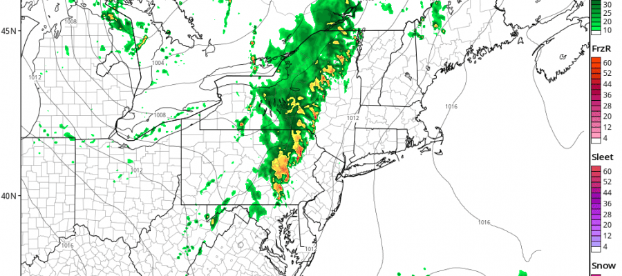
First things first and that is today where we are once again going to experience very warm and humid conditions. There are some scattered downpours and thunderstorms on the radar this morning. Some pop up thunderstorms are possible this afternoon and evening but this will be another case where the vast majority of you won’t see much. If you do it is possible that some of the individual thunderstorms could get strong or even severe. Flash flooding from heavy rain is the biggest threat as has been the case the last several days.
REGIONAL RADAR

LOCAL RADAR NEW YORK CITY

LOCAL RADAR PHILADELPHIA


This is the view of the HRRR model at midnight tonight. This model seems a little faster than the others showing this line of thunderstorms to the west in Central Pennsylvania.

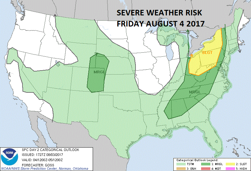
The question is whether this line holds together or not which is always the big battle in trying to figure out. Some models do more with this and others far less. Either way it would seem that by midday Saturday from NYC west it should be partly to mostly sunny or at least on the way to that..and east of NYC it will wait until early afternoon. The Storm Prediction Center is indicating a slight risk for severe weather today in areas well west of the coast.
 GET JOE A CIGAR IF YOU LIKE

LANDSCAPE COMPANIES FOR YOUR NEEDS
LONG ISLAND ROCKLAND COUNTY Connecticut

![]()

ROCKLAND COUNTY TRI STATE SNOW REMOVAL JOHNSTOWN PA


FiOS1 News Weather Forecast For Long Island
FiOS1 News Weather Forecast For New Jersey
FiOS1 News Weather Forecast For Hudson Valley
NATIONAL WEATHER SERVICE SNOW FORECASTS
LATEST JOESTRADAMUS ON THE LONG RANGE
Weather App

Don’t be without Meteorologist Joe Cioffi’s weather app. It is really a meteorologist app because you get my forecasts and my analysis and not some automated computer generated forecast based on the GFS model. This is why your app forecast changes every 6 hours. It is model driven with no human input at all. It gives you an icon, a temperature and no insight whatsoever.
It is a complete weather app to suit your forecast needs. All the weather information you need is right on your phone. Android or I-phone, use it to keep track of all the latest weather information and forecasts. This weather app is also free of advertising so you don’t have to worry about security issues with your device. An accurate forecast and no worries that your device is being compromised.
Use it in conjunction with my website and my facebook and twitter and you have complete weather coverage of all the latest weather and the long range outlook. The website has been redone and upgraded. Its easy to use and everything is archived so you can see how well Joe does or doesn’t do when it comes to forecasts and outlooks.
Just click on the google play button or the apple store button on the sidebar for my app which is on My Weather Concierge. Download the app for free. Subscribe to my forecasts on an ad free environment for just 99 cents a month.
Get my forecasts in the palm of your hand for less than the cost of a cup of Joe!


