Long Stretch of Nice Weather Coming Fingers Crossed
It has been a long time probably many months since we have seen a long stretch of at least 4 days of nice weather. Keep your fingers crossed as the way the weather pattern is shaping up, we could be in for such a stretch beginning Friday and lasting possibly into next Monday! Certainly yesterday and today were great days with sunshine, a nice breeze, and temperatures a bit on the cool side of average but certainly acceptable for most. We have one change to work through Wednesday night into Thursday before our long stretch (hopefully) settles in place and in time for the weekend!
SATELLITE

REGIONAL RADAR

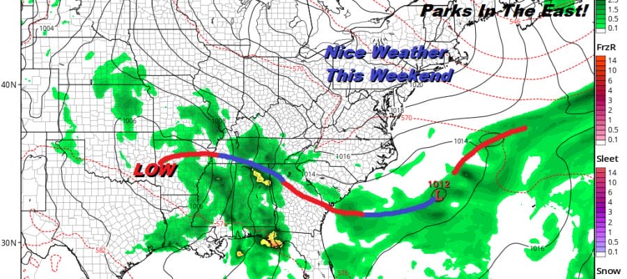
The satellite picture from this afternoon shows us in a good place. The next warm front cold front combination is developing but this time around the warm front is setting up to our northwest where you see the heavier cloud cover in upstate NY. We don’t have much to worry about this and we will have a good day Wednesday with sunshine most of the day. Temperatures will reach the upper 70s and lower 80s just about everywhere with middle 80s possible in Western New Jersey and Eastern Pennsylvania with 70s along the immediate coast.
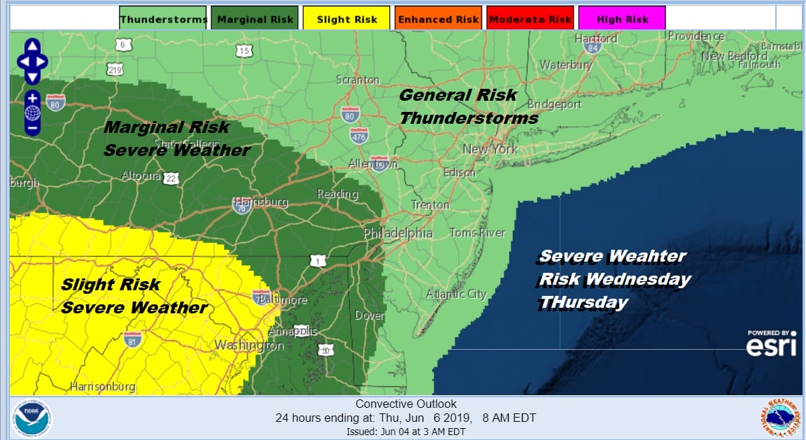
Wednesday evening into Thursday morning we have slow moving cold front to deal with. At the moment we are not at risk for severe weather per the Storm Prediction Center but I would not be surprised to see the marginal risk extending northeastward as well as the slight risk. Thunderstorms will develop tomorrow evening and we will see widespread activity Wednesday night into early Thursday morning. Then we should break out into some sunshine with another shower or thunderstorm possibility late in the day Thursday as the cold front passes.
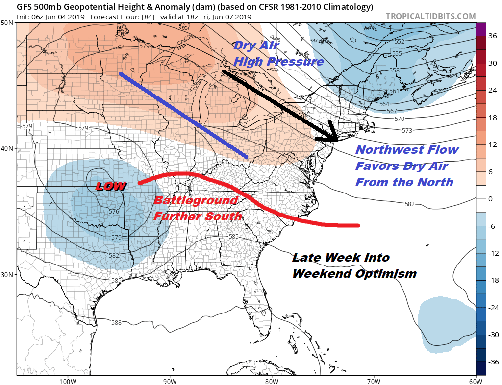
The upper air pattern that develops late this week is going to be just perfect if it holds for nice weather Friday through Monday. Low pressure in the Plains remains locked there thanks to a strong ridge building from the Mid Atlantic States northwestward into the Western Great Lakes & Minnesota. To the east an upper low keeps us on the edge of a northwest flow which is dry. The cold front Thursday stalls but it stalls out well to the south. This puts us in a nice sweet spot!
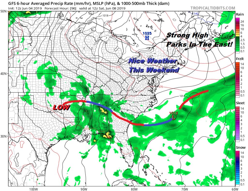
That high brings dry air and sunshine Friday and since the high is going to move southeast to off the New Jersey coast late Sunday, we should be fine here. The northeast flow will keep it from getting hot and it isn’t a moist flow. It will be a dry one. Friday Saturday and Sunday highs will be in the upper 70s to lower 80s in most places with some middle 80s inland. Nighttime lows will be in the 60s with 50s in cool spots. That low in Arkansas won’t be able to bring showers and thunderstorms here until Monday night at the earliest and if the ridge holds on it might wait until Tuesday. Fingers crossed!
MANY THANKS TO TROPICAL TIDBITS FOR THE USE OF MAPS
Please note that with regards to any tropical storms or hurricanes, should a storm be threatening, please consult your local National Weather Service office or your local government officials about what action you should be taking to protect life and property.


