
Long Range Blocking Continues For Late April Early May

MENTION JOE CIOFFI AND GET A 5% DISCOUNT
A fairly strong long range blocking continues across the North Atlantic and the latest weather model runs show it holding pretty much firm over the next week to 10 days. It is funny how over the winter time weather models gave several signals along the way and each one never came to be. It took us getting into mid spring and the continued demise of El Nino in order to get a truly solid blocking pattern to set up. But such is life in the weather world these days. Actually this is a throwback to many winters in the 70s 80s and 90s when this sort of thing seem to happen almost every spring. The implications of blocking this time of year is that it keeps things cooler than normal (overall) and it allows weather systems to pass by to our south. This means frequent intrusions of marine air, onshore flow, and some rain every few days. The pattern appears active in this regard as there are several weather systems that will be taking that particular route. This should allow for some much needed rain to occur. However at the moment there does not appear to be any signal regarding a late season noreaster. Upper air disturbances would have to line up perfectly for something like that to occur.
Long Range Blocking Continues

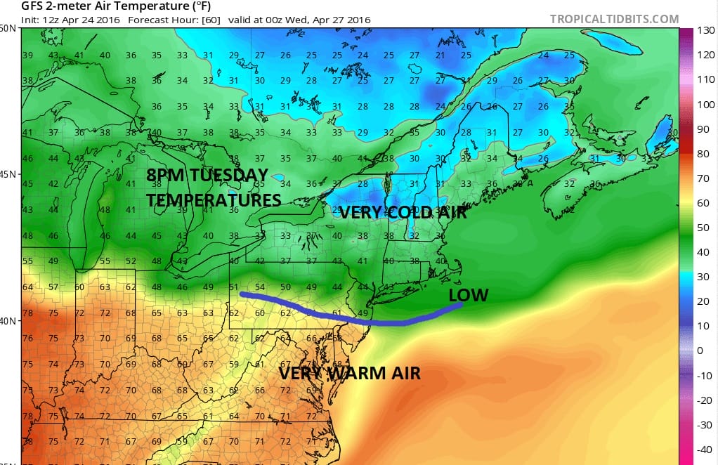
The first weather system comes through on Tuesday. The initial boundary between warm and cold air sets up along Interstate 90 in upstate New York and New England. That gives us 1 day of 70s to around 80 on Monday with some sunshine. Then the front sags south and we get into some rain and a few heavier downpours or even thunderstorms on Tuesday. The front goes by. Temperatures drop into the 40s and 50s.
Long Range Blocking Continues
Wednesday looks to be dry sunny and cool with high pressure building down from the northern Great Lakes. Since there is a log jam developing in the atmosphere nothing seems to want to move from west to east in Canada so the next disturbance that comes out of the plains heads across the Ohio Valley and to the Middle Atlantic Coast for later Thursday and Thursday night. Some rain is possible with this though we will have to see how strong the block actually is. Too strong and it forces that area even further south.
Long Range Blocking Continues
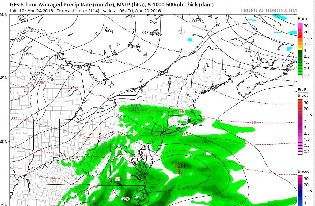
We dry out Friday and Saturday and the next system follows for Sunday. If the block holds beyond day 7 that system looks to track over or just to our south as well but it will depend on whether the upper air storm to the northeast near 50N 50W decides to get out of the way or not. One thing about blocking patterns is when they are strong, models tend to weaken them too quickly and they hang around a bit longer than forecast. Such may be the case this time around. It would be a good thing if we could get one good soaking rain out of these weather systems. One thing that will be a constant through all this is that temperatures will be near or below normal through the period. Yes there will be the odd day here and there where temperatures could warm up but it won’t last more than a day or so.
FiOS1 News Weather Forecast For Long Island
FiOS1 News Weather Forecast For New Jersey
FiOS1 News Weather Forecast For Hudson Valley
NATIONAL WEATHER SERVICE SNOW FORECASTS
LATEST JOESTRADAMUS ON THE LONG RANGE

NOMINATED FOR AN APPY AWARD FOR BEST WEATHER APP!!
Weather App

Don’t be without Meteorologist Joe Cioffi’s weather app. It is really a meteorologist app because you get my forecasts and my analysis and not some automated computer generated forecast based on the GFS model. This is why your app forecast changes every 6 hours. It is model driven with no human input at all. It gives you an icon, a temperature and no insight whatsoever.
It is a complete weather app to suit your forecast needs. All the weather information you need is right on your phone. Android or I-phone, use it to keep track of all the latest weather information and forecasts. This weather app is also free of advertising so you don’t have to worry about security issues with your device. An accurate forecast and no worries that your device is being compromised.
Use it in conjunction with my website and my facebook and twitter and you have complete weather coverage of all the latest weather and the long range outlook. The website has been redone and upgraded. Its easy to use and everything is archived so you can see how well Joe does or doesn’t do when it comes to forecasts and outlooks.
Just click on the google play button or the apple store button on the sidebar for my app which is on My Weather Concierge. Download the app for free. Subscribe to my forecasts on an ad free environment for just 99 cents a month.
Get my forecasts in the palm of your hand for less than the cost of a cup of Joe!
![]()

