Last Very Warm Day Thunderstorms Cooler Weekend
Last Very Warm Day Thunderstorms Cooler Weekend
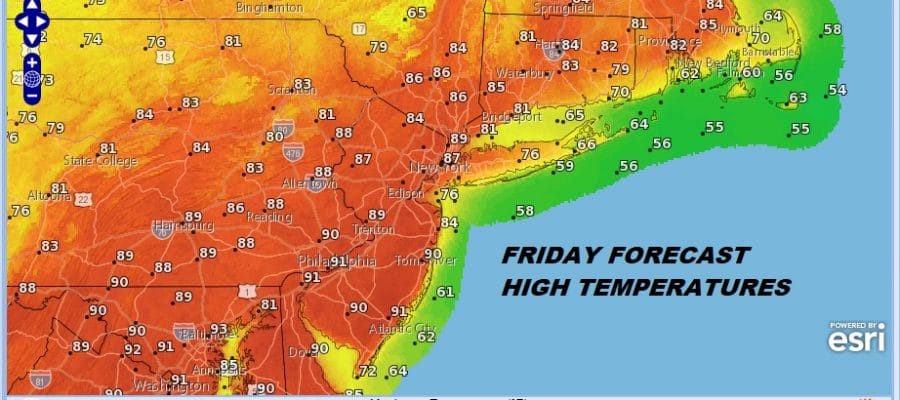
After yesterday’s hot day with highs in the 90s and some strong to severe thunderstorms in some places during the evening, we aim to do it one more time today. One thing that may keep temperatures a bit lower today is cloud cover and a bit more of an southwest wind along coastal areas. Highs however should still reach the mid 80s to near 90 in most places with 70s along the shore.
FRIDAY FORECAST HIGH TEMPERATURES

For some places this will be the first heatwave of the season with three 90 degree days in a row. This is one of many reasons why we have always liked the 5 day definition of a heat wave. But that is an argument for another day. Late this afternoon and evening a cold front will approach. The satellite picture this morning doesn’t show much going on nearby but there are showers to the west and north.
US SATELLITE

REGIONAL RADAR

The regional radar is showing some downpours moving across Western & Northern Pennsylvania into Western & Central NY. Those showers will be going by to our north this morning but the boundary will begin to shift southward during this afternoon.
LOCAL RADAR NEW YORK CITY

LOCAL RADAR PHILADELPHIA


The Storm Prediction Center does have the area in a slight risk for severe weather late today into tonight for almost all of Pennsylvania into Northwest New Jersey, the Hudson Valley into the northwest corner of Connecticut. Marginal risks extends east to the coast From the rest of Northwest CT to NYC & Philadelphia. The wind off the ocean will likely temper thunderstorms further east along coastal areas.

It appears the weekend forecast is going to be a bit complicated by this front stalling out. A low off the Florida coast develops with some moisture and that will shoot northward Saturday night and Sunday as another front swings eastward. Much of the Atlantic moisture will stay offshore but some of it will get in here. This will probably keep us in cloud cover on Saturday though some breaks of sun are not impossible. Highs will be in the low to mid 70s in most places.
GFS FORECAST SUNDAY MAY 6, 2018
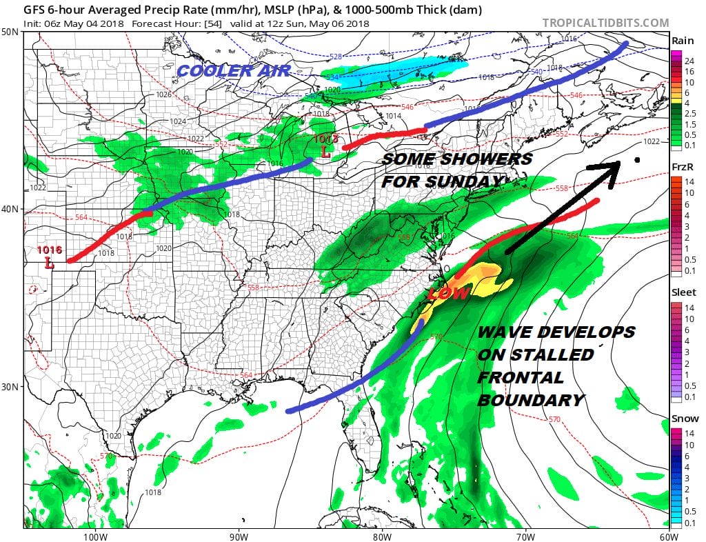
Sunday brings some showers and cooler temperatures with highs in the 60s. This doesn’t appear to be a heavy soaking rain but more of a nuisance rain. Weather conditions do improve early next week but that frontal boundary along the coast could send another low northward later next week.
 GET JOE A CIGAR IF YOU LIKE

FiOS1 News Weather Forecast For Long Island
FiOS1 News Weather Forecast For New Jersey
FiOS1 News Weather Forecast For Hudson Valley


