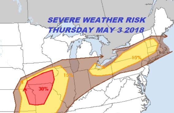
Severe Weather Risk Thursday May 3 2018
Severe Weather Risk Thursday May 3 2018
The daytime heating of temperatures near or over 90 degrees opens the door for the possibility of scattered thunderstorms late this afternoon and tonight over parts of our area from Eastern Pennsylvania to Southern New England. The Storm Prediction Center has put parts of Northern and Northeastern Pennsylvania as well as the Catskills and the Hudson Valley north of Route 84 at a slight risk for severe weather late today into tonight with a marginal risk extending southward into New Jersey & Eastern Pennsylvania mainly north and west of Route 78. The marginal risk also extends into Connecticut.

Much of the energy for today goes by to our north across the Middle & Upper Hudson Valley where I think the risk is higher for severe thunderstorms. Also you will notice on the Storm Prediction Center risk map that the Midwest and Ohio Valley are bearing the brunt of a more widespread severe weather outbreak today.
There will be a greater chance for thunderstorms late in the day Friday or more than likely Friday night with a stronger cold front approaching. For now the Storm Prediction Center has a marginal risk for severe weather Friday for our area. We can say that for both today and Friday, much of the day and night will be fine and it is quite possible that some of you may not even see a shower today or Friday.
FiOS1 News Weather Forecast For Long Island
FiOS1 News Weather Forecast For New Jersey
FiOS1 News Weather Forecast For Hudson Valley
NATIONAL WEATHER SERVICE SNOW FORECASTS
LATEST JOESTRADAMUS ON THE LONG RANGE


