Last Round of Rain Weather Improves Saturday Gloom Doom Back Sunday Into Monday
Overnight rain has moved through and now we are seeing the last round of rain going by. Low pressure is developing off the New Jersey coast and heading east northeast and offshore. This is going to keep us in the onshore flow for the rest of the day. Once this last batch of rain passes we will still be in lots of clouds going into tonight. However at least we should start to dry out overnight and set up for a better day on Saturday.
SATELLITE

REGIONAL RADAR

The regional and local radars are still busy with rain moving southwest to northeast and there is some heavy rain in the mix coming out of New Jersey and heading for Long Island and Southern New England. The rains are more showery in nature as you head west and south into Pennsylvania Delaware and Maryland. Temperatures are in the 40s over much of the area and will have a tough time getting out of the 40s in most places.
LOCAL RADAR NEW YORK CITY

LOCAL RADAR DOVER


As far as the weekend is concerned Saturday is the better of the two weekend days without question. We should see some sunshine and that will be enough to send temperatures back to the upper 50s to lower 60s. This is still below average for this time of year as mid 60s would be the norm but in this wet cool pattern we take whatever we can get.

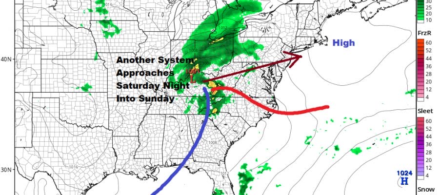
Saturday night and Sunday, here comes the next one! Low pressure moving out of the Plains follows an almost identical track to today’s weather system with a low going to West Virginia, redeveloping off the Delaware coast, and then headed very slowly northeast. This puts us back in rain for Sunday in an onshore flow and temperatures mostly in the mid 40s to lower 50s.

The low will still be around keeping us in clouds and showers for Monday before weather conditions improve. We squeeze in a dry day on Tuesday which will be much like Saturday with some sunshine and highs into the 60s. Then we see the next storm heading for the Great Lakes Wednesday with a trailing cold front. At least this keeps us out of the onshore flow but will bring showers and perhaps a few thunderstorms late Wednesday into Wednesday night.
BE SURE TO DOWNLOAD THE FREE METEOROLOGIST JOE CIOFFI WEATHER APP &
ANGRY BEN’S FREE WEATHER APP “THE ANGRY WEATHERMAN!
MANY THANKS TO TROPICAL TIDBITS FOR THE USE OF MAPS
Please note that with regards to any severe weather, tropical storms, or hurricanes, should a storm be threatening, please consult your local National Weather Service office or your local government officials about what action you should be taking to protect life and property.


