
July Autumn Weather Lasts Into Weekend

July Autumn Weather Lasts Into Weekend
It was another day of cool temperatures and lots of clouds with some passing showers as temperatures along the coast did not get out of the 60s and inland highs were generally in the 70s. This cool surface pattern that has settled in will continue to be the dominant pattern into the weekend. The satellite loop shows dry air over Northeastern New England moving southwestward and it should reach us overnight and penetrate somewhat but not far inland on Wednesday. This could create mostly sunny conditions along the coast and partly sunny to mostly cloudy conditions inland on Wednesday. Highs will be mostly in the 70s.
SATELLITE LOOP

REGIONAL RADAR

Activity on the regional and local radars continues to weaken as we move past sunset. Other than a passing sprinkle until about midnight in a couple of spots, the night should be rain free in most areas.
LOCAL RADAR NEW YORK CITY

LOCAL RADAR PHILADELPHIA


Thursday could be the one day we might reach into the 80s but clouds will be an issue as a front approaches from the west. Then we set our sights on Friday and Saturday with low pressure developing to our south. Weather models are showing a robust upper air system swinging through but timing and placement remain a big question. Since we have seen this onshore cool pattern twice in the last few weeks, it would be no surprise to see it happen again.
GFS RAINFALL FORECAST THROUGH SATURDAY 2PM
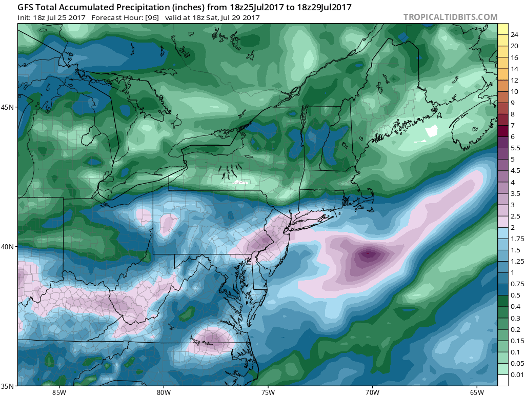
The upper dynamics are strong enough for someone to see a couple of inches of rain Friday into Saturday. Areas in South Jersey & Southeastern Pennsylvania are soaked and they could be especially vulnerable to flash flooding should a heavy rain materialize. Right now im thinking that clouds will be here Friday and Saturday and rain is possible from NYC & Long Island northward and probable south. Temperatures will be in the 70s Friday and Saturday with an onshore flow and if the rains move far enough north we may wind up in the 60s. Sunshine should return on Sunday as low pressure to the south moves away to the northeast. I’m still not a hundred percent sold on this but I am leaning in the direction of rain at the moment.
 GET JOE A CIGAR IF YOU LIKE

LANDSCAPE COMPANIES FOR YOUR NEEDS
LONG ISLAND ROCKLAND COUNTY Connecticut

![]()

ROCKLAND COUNTY TRI STATE SNOW REMOVAL JOHNSTOWN PA


FiOS1 News Weather Forecast For Long Island
FiOS1 News Weather Forecast For New Jersey
FiOS1 News Weather Forecast For Hudson Valley
NATIONAL WEATHER SERVICE SNOW FORECASTS
LATEST JOESTRADAMUS ON THE LONG RANGE
Weather App

Don’t be without Meteorologist Joe Cioffi’s weather app. It is really a meteorologist app because you get my forecasts and my analysis and not some automated computer generated forecast based on the GFS model. This is why your app forecast changes every 6 hours. It is model driven with no human input at all. It gives you an icon, a temperature and no insight whatsoever.
It is a complete weather app to suit your forecast needs. All the weather information you need is right on your phone. Android or I-phone, use it to keep track of all the latest weather information and forecasts. This weather app is also free of advertising so you don’t have to worry about security issues with your device. An accurate forecast and no worries that your device is being compromised.
Use it in conjunction with my website and my facebook and twitter and you have complete weather coverage of all the latest weather and the long range outlook. The website has been redone and upgraded. Its easy to use and everything is archived so you can see how well Joe does or doesn’t do when it comes to forecasts and outlooks.
Just click on the google play button or the apple store button on the sidebar for my app which is on My Weather Concierge. Download the app for free. Subscribe to my forecasts on an ad free environment for just 99 cents a month.
Get my forecasts in the palm of your hand for less than the cost of a cup of Joe!


