Jose Off East Coast Last Summer Weekend
Jose Off East Coast Last Summer Weekend
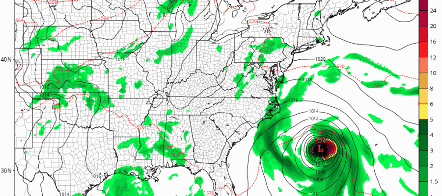
This is the last summer weekend before autumn arrives later next week. At least it will live up to summer to a large degree. We are seeing sunshine for much of the coastal areas today with some clouds inland. We are also going to see some pop up downpours late this afternoon and evening but they will be widely scattered. We also have Jose which may have strengthened back to a hurricane. An Air Force plane is enroute to investigate it. Jose looms a threat to the East Coast early next week but the extent of that threat remains a mystery at this point. It looks like it could be a near miss or a very near miss or even a graze for some areas depending on which model you look at. However we can say there will be no weather issues from Jose over the weekend.
SATELLITE LOOP

REGIONAL RADAR

LOCAL RADAR NEW YORK CITY

LOCAL RADAR PHILADELPHIA


With regards to Saturday and Sunday we will see sunshine both days with highs into the 80s. There is the small risk for a pop up downpour on Saturday but that should be minimal and most of you won’t see any. Monday we will start to look southward to Jose. The threat period will begin during Monday night as weather conditions start to deteriorate somewhat but it will again depend on the ultimate track of Jose. The forecast here is very complicated and we will go into detail later this afternoon once we see all the new weather model outputs. If you are headed to the beaches this weekend be advised that rip currents and rough seas will continue to be a big issue so relax but do so cautiously and safely.
GFS MODEL RUN SUNDAY AFTERNOON INTO TUESDAY MORNING
CLICK TO ANIMATE
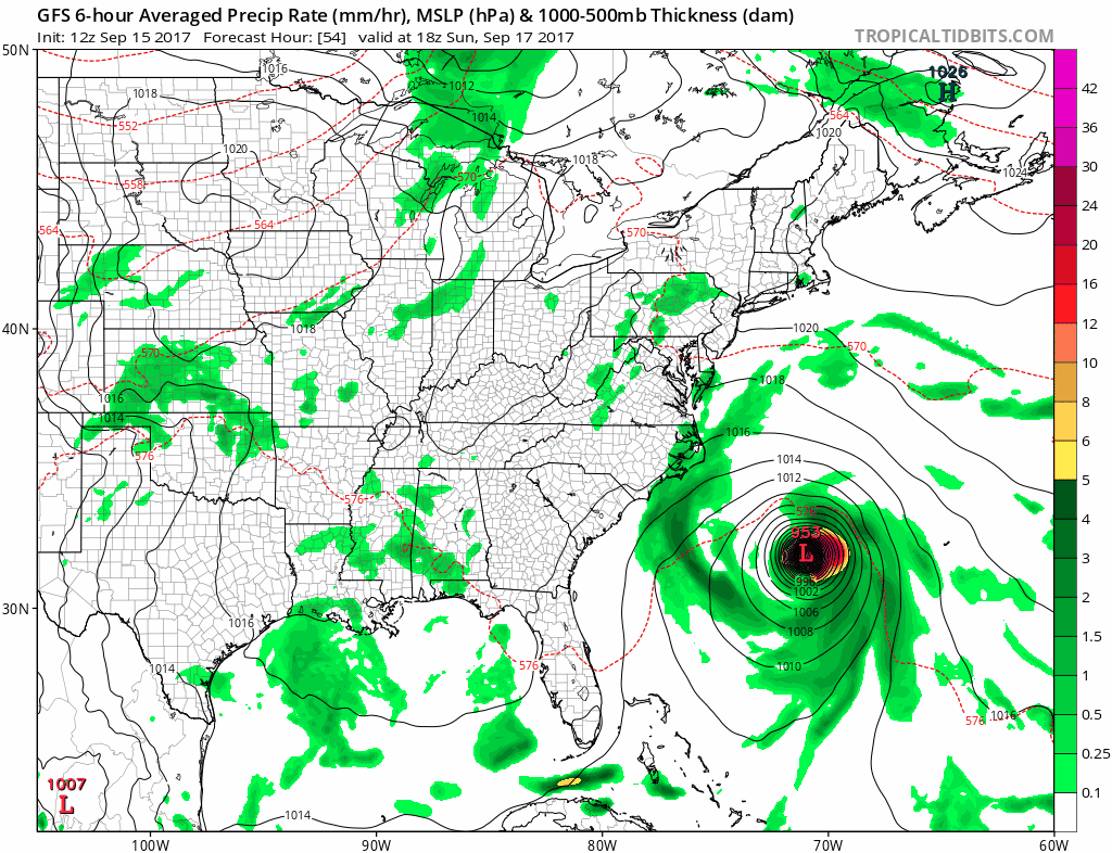
We have a quick look at the new GFS which takes us out into 2am Tuesday. The track on this run is further east so far but we don’t quite know what happens to this after Tuesday morning. We will again update all of this later this afternoon. Notice that in this position the impacts are to the east of New Jersey at least at the onset with weather conditions worsening from east to west across Southeastern New England and Eastern Long Islands. Again this is an early view.
…AN AIR FORCE PLANE IS EN ROUTE TO DETERMINE IF JOSE IS A
HURRICANE AGAIN…
SUMMARY OF 1100 AM AST…1500 UTC…INFORMATION
———————————————–
LOCATION…26.5N 69.4W
ABOUT 360 MI…575 KM NE OF THE SOUTHEASTERN BAHAMAS
ABOUT 485 MI…785 KM SW OF BERMUDA
MAXIMUM SUSTAINED WINDS…70 MPH…110 KM/H
PRESENT MOVEMENT…NW OR 305 DEGREES AT 9 MPH…15 KM/H
MINIMUM CENTRAL PRESSURE…989 MB…29.21 INCHES
WATCHES AND WARNINGS
——————–
There are no coastal watches or warnings in effect.
Interests from North Carolina northward to New England on the east
coast of the United States should monitor the progress of this
system.
DISCUSSION AND 48-HOUR OUTLOOK
——————————
At 1100 AM AST (1500 UTC), the center of Tropical Storm Jose was
located near latitude 26.5 North, longitude 69.4 West. Jose is
moving toward the northwest near 9 mph (15 km/h). This general
motion is expected today, follow by a turn to the north-northwest
by late Saturday and toward the north on Sunday.
Maximum sustained winds remain near 70 mph (110 km/h) with higher
gusts. Some strengthening is forecast during the next 48 hours. An
Force Reserve Hurricane Hunter aircraft is currently en route to
obtain a better wind speed estimate.
Tropical-storm-force winds extend outward up to 140 miles (220 km)
from the center.
The estimated minimum central pressure is 989 mb (29.21 inches).
HAZARDS AFFECTING LAND
———————-
SURF: Swells generated by Jose are affecting Bermuda, the Bahamas,
the northern coasts of Hispaniola and Puerto Rico, and the southeast
coast of the United States, and will spread northward along the
Mid-Atlantic coast of the U.S. during the next few days. These
swells are likely to cause life-threatening surf and rip current
conditions. For more information, please consult products from your
local weather office.
 GET JOE A CIGAR IF YOU LIKE

FiOS1 News Weather Forecast For Long Island
FiOS1 News Weather Forecast For New Jersey
FiOS1 News Weather Forecast For Hudson Valley


