Jose Better Organized 2 New Tropical Storms Developing
Jose Better Organized 2 New Tropical Storms Developing
JOSE THREAT TO COASTAL AREAS OF THE NORTHEAST
TROPICAL DEPRESSION IN EASTERN ATLANTIC NO THREAT
NEW TROPICAL STORM FORECAST TO FORM EAST OF LEEWARDS
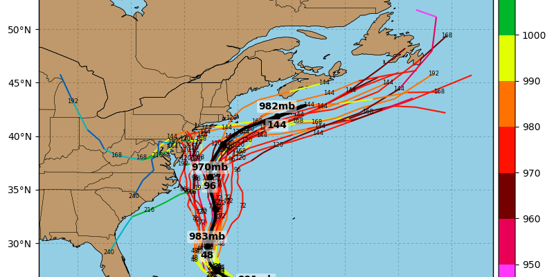
It appears that the tropics are about to go into overdrive here as by Sunday we may have 3 named storms again and 2 of them are going to be land threats. Let’s start with Jose which overnight and this morning looks better defined. Jose is moving toward the west northwest and will continue this track into Saturday. After that it is a northward turn and up the east coast just offshore with various models showing now a wide variety of possibilites

…JOSE EXPECTED TO PRODUCE HIGH SURF AND LIFE-THREATENING RIP
CURRENTS ALONG PORTIONS OF THE U.S. EAST COAST…
SUMMARY OF 500 AM AST…0900 UTC…INFORMATION
———————————————-
LOCATION…25.9N 68.7W
ABOUT 360 MI…575 KM NE OF THE SOUTHEASTERN BAHAMAS
ABOUT 500 MI…805 KM SSW OF BERMUDA
MAXIMUM SUSTAINED WINDS…70 MPH…110 KM/H
PRESENT MOVEMENT…WNW OR 290 DEGREES AT 8 MPH…13 KM/H
MINIMUM CENTRAL PRESSURE…989 MB…29.21 INCHES
WATCHES AND WARNINGS
——————–
There are no coastal watches or warnings in effect.
Interests from North Carolina northward to New England on the east
coast of the United States should monitor the progress of this
system.
DISCUSSION AND 48-HOUR OUTLOOK
——————————
At 500 AM AST (0900 UTC), the center of Tropical Storm Jose was
located near latitude 25.9 North, longitude 68.7 West. Jose is
moving toward the west-northwest near 8 mph (13 km/h). A gradual
turn toward the north is expected later today and on Saturday.
Maximum sustained winds are near 70 mph (110 km/h) with higher
gusts. Some strengthening is forecast during the next 48 hours.
Jose is forecast to become a hurricane later today.
Tropical-storm-force winds extend outward up to 140 miles (220 km)
from the center.
The estimated minimum central pressure is 989 mb (29.21 inches).
HAZARDS AFFECTING LAND
———————-
SURF: Swells generated by Jose are affecting Bermuda, the Bahamas,
the northern coasts of Hispaniola and Puerto Rico, and the Southeast
coast of the United States, and will spread northward along the
Mid-Atlantic coast of the U.S. during the next few days. These
swells are likely to cause life-threatening surf and rip current
conditions. For more information, please consult products from your
local weather office.
NEXT ADVISORY
————-
Next complete advisory at 1100 AM AST.
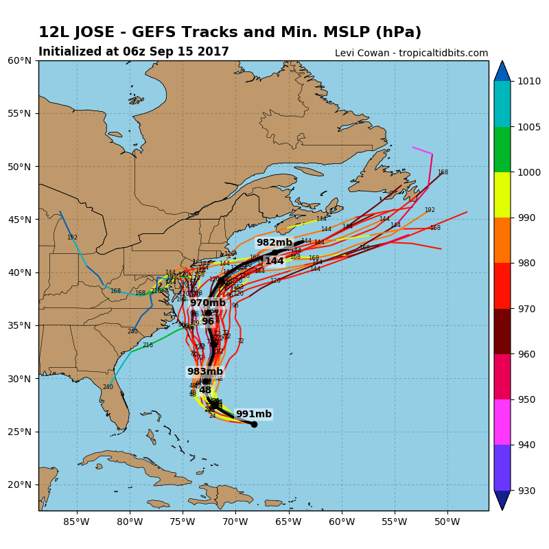

There are all sorts of various possibilities over that weather models came up with last night. I think that it is safe to say at the very least Jose will be a very close call for the Northern Middle Atlantic & Northeastern US and this will be a hair pulling forecast. The threat for this area has increased since yesterday and we will watch what the day side models do with this. Jose is likely to become a hurricane later today.

Meanwhile we have a tropical wave moving westward in the Central Tropical Atlantic that is becoming better organized and will likely become a tropical depression or tropical storm over the weekend. It is also going to threaten the Leeward Islands and then it may be on to the Greater Antilles. Some of the same areas that were impacted either directly or indirectly from Irma and Jose may be impacted again as early as Monday or Tuesday of next week.

In the far Eastern Atlantic we have Tropical Depression 14 which looks well organized and is likely to reach tropical storm strength later today. This one is no threat to land.
..TROPICAL DEPRESSION MOVING WESTWARD OVER THE FAR EASTERN
ATLANTIC…
…FORECAST TO BECOME A TROPICAL STORM…
SUMMARY OF 500 AM AST…0900 UTC…INFORMATION
———————————————-
LOCATION…10.6N 27.3W
ABOUT 435 MI…700 KM SSW OF THE CABO VERDE ISLANDS
MAXIMUM SUSTAINED WINDS…35 MPH…55 KM/H
PRESENT MOVEMENT…W OR 270 DEGREES AT 15 MPH…24 KM/H
MINIMUM CENTRAL PRESSURE…1008 MB…29.77 INCHES
WATCHES AND WARNINGS
——————–
There are no coastal watches or warnings in effect.
DISCUSSION AND 48-HOUR OUTLOOK
——————————
At 500 AM AST (0900 UTC), the center of Tropical Depression Fourteen
was located near latitude 10.6 North, longitude 27.3 West. The
depression is moving toward the west near 15 mph (24 km/h), and this
motion is expected to continue during the next couple of days.
Maximum sustained winds are near 35 mph (55 km/h) with higher gusts.
The depression is forecast to become a Tropical Storm later today
or tomorrow.
The estimated minimum central pressure is 1008 mb (29.77 inches).
HAZARDS AFFECTING LAND
———————-
None
MANY THANKS TO TROPICAL TIDBITS FOR THE WONDERFUL USE OF THE MAPS
 GET JOE A CIGAR IF YOU LIKE

Weather App

Don’t be without Meteorologist Joe Cioffi’s weather app. It is really a meteorologist app because you get my forecasts and my analysis and not some automated computer generated forecast based on the GFS model. This is why your app forecast changes every 6 hours. It is model driven with no human input at all. It gives you an icon, a temperature and no insight whatsoever.
It is a complete weather app to suit your forecast needs. All the weather information you need is right on your phone. Android or I-phone, use it to keep track of all the latest weather information and forecasts. This weather app is also free of advertising so you don’t have to worry about security issues with your device. An accurate forecast and no worries that your device is being compromised.
Use it in conjunction with my website and my facebook and twitter and you have complete weather coverage of all the latest weather and the long range outlook. The website has been redone and upgraded. Its easy to use and everything is archived so you can see how well Joe does or doesn’t do when it comes to forecasts and outlooks.
Just click on the google play button or the apple store button on the sidebar for my app which is on My Weather Concierge. Download the app for free. Subscribe to my forecasts on an ad free environment for just 99 cents a month.
Get my forecasts in the palm of your hand for less than the cost of a cup of Joe!