JOESTRADAMUS CELEBRATES CHRISTMAS

JOESTRADAMUS CELEBRATES CHRISTMAS
Merry Christmas to everyone. Thank you so much for being here on a daily basis. I woke up this morning to a beautiful White Christmas with about 2 to 3 inches of snow of fresh snow on the ground with snow coming down. It was by far the prettiest Christmas morning’s I’ve ever witnessed
We extend all the best wishes to you and your family on this Christmas morning. For you winter weather loves we have a very cold week ahead of us. All of this will be passing away to the east shortly with windy conditions and leftover clouds with some sun this afternoon. Temperatures will be in the 30s to near 40. Tonight we head down to lows in the 20s with some upper teens inland. The satellite loop shows the snow moving right along here to the east as the back edge moves into Western New England.
SATELLITE LOOP

Snow continues on the radar today across New England with much of the northeast enjoying a beautiful White Christmas.
REGIONAL RADAR

LOCAL RADAR NEW YORK CITY

LOCAL RADAR PHILADELPHIA


The next 10 days look to be very cold with arctic air with us in varying degrees. Tuesday’s highs will just be into the 30s and for the rest of the week daytime highs probably won’t be much out of the 20s. Nights will begin dropping to the single digits to mid teens. Snow threats are on the table for late this week and for New Years with the potential for 2 weather systems.
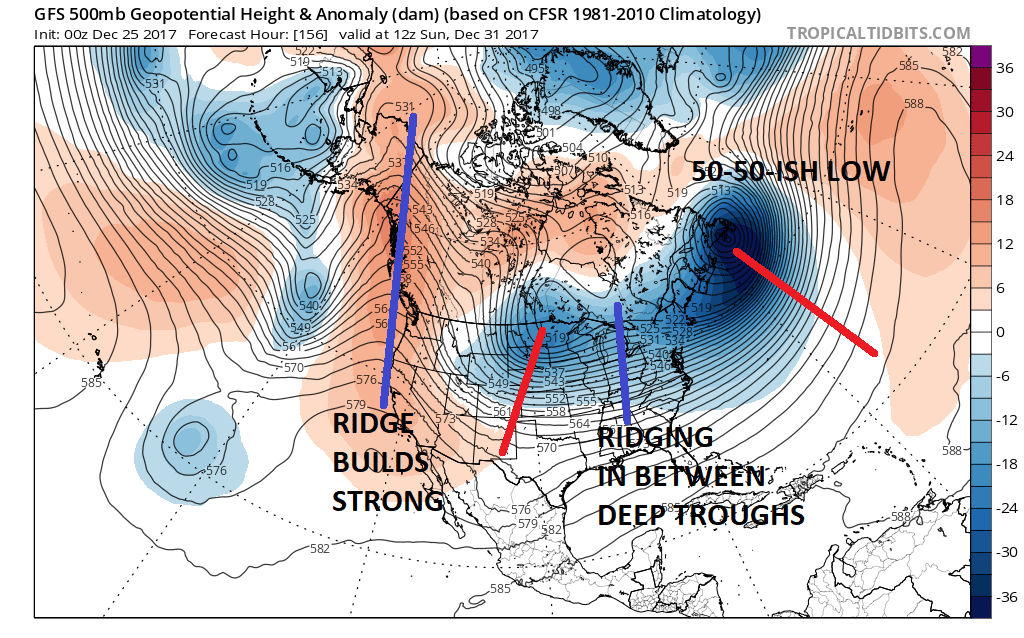
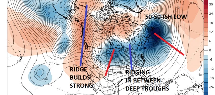
The key to these system is the strength of each one and more importantly the ridge that pops up in between This creates room for systems to either move up the East Coast from the south or it develops lows with northern stream energy just close enough to bring us snow. The first of these is Friday as low pressure moves offshore from the south and northern energy swings in from the west.
GFS MODEL THURSDAY FRIDAY CLICK TO ANIMATE
We will be waiting for model runs this afternoon to reevaluate the situation. In the meantime enjoy your Christmas Day.
MANY THANKS TO TROPICAL TIDBITS FOR THE WONDERFUL USE OF THE MAPS

GET JOE A CIGAR IF YOU LIKE!
FiOS1 News Weather Forecast For Long Island
FiOS1 News Weather Forecast For New Jersey
FiOS1 News Weather Forecast For Hudson Valley
NATIONAL WEATHER SERVICE SNOW FORECASTS
LATEST JOESTRADAMUS ON THE LONG RANGE
Weather App

Don’t be without Meteorologist Joe Cioffi’s weather app. It is really a meteorologist app because you get my forecasts and my analysis and not some automated computer generated forecast based on the GFS model. This is why your app forecast changes every 6 hours. It is model driven with no human input at all. It gives you an icon, a temperature and no insight whatsoever.
It is a complete weather app to suit your forecast needs. All the weather information you need is right on your phone. Android or I-phone, use it to keep track of all the latest weather information and forecasts. This weather app is also free of advertising so you don’t have to worry about security issues with your device. An accurate forecast and no worries that your device is being compromised.
Use it in conjunction with my website and my facebook and twitter and you have complete weather coverage of all the latest weather and the long range outlook. The website has been redone and upgraded. Its easy to use and everything is archived so you can see how well Joe does or doesn’t do when it comes to forecasts and outlooks.
Just click on the google play button or the apple store button on the sidebar for my app which is on My Weather Concierge. Download the app for free. Subscribe to my forecasts on an ad free environment for just 99 cents a month.
Get my forecasts in the palm of your hand for less than the cost of a cup of Joe!