
JOESTRADAMAS: Thanksgiving Week Weather Starts Cold
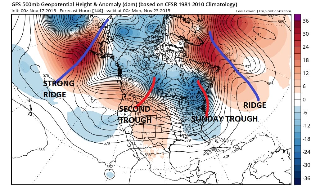
Right now what we can say about the Thanksgiving week weather is that there doesn’t appear to be any big storms to worry about. The upper flow does not appear to be conducive to storm development and much of the week at this point looks dry. There are a few things we do know. First is that Sunday through Tuesday look cold. The coldest will be Sunday and Monday. The GFS this afternoon is hinting at 2 things. First is that the cold air that is being driven by the first trough that comes through Sunday is a little slower and deeper which means it takes longer to pull out. Second is that there is another upstream system that is going to at least keep it from getting warm through at least midweek. There appears to be a weak reinforcement of cold air coming on Tuesday that should keep things close to normal into midweek.
Now I’m going to jump ahead to the last day of the month where the GFS has done a flip from the day run. This is the ongoing problem with the model beyond the 7 to 10 day period. Yes the ridge in the east wants to pump up yet again but unlike the day run the night run has a different orientation across the northern latitudes. Remember a few days ago it was showing building high pressure aloft from Greenland west and from Alaska east. Today’s day run had the vortex reforming in Alaska and Siberia with the pattern we are in now basically repeating. Now it has a vortex way north across from Alaska to Greenland with a trough extending down from there through East Central Canada! This will keep the east ridge flatter than it otherwise would be.

Also when you look at the surface through this period the low levels are not all that warm at all. The bottom line is that I think we will continue to see run to run changes here as we go forward. Part of the problem is that there is a large volatility in the forecasts for NAO/AO at the end of the month with some members going negative and some staying positive. Early ensembles were split fairly evenly on this.
Im thinking that at least through early next week the thing to watch is that second trough in the graphic above that might wind up being stronger than is now forecast which might prolong the colder air for a day or 2. Again even with all of this going on no big storms are on the horizon. The other issue is that the gfs wants to make a tropical storm off the southeast US coast (well offshore). Frankly I don’t know if that is even a real feature at this point.
I will have a more detailed look after a good night sleep.
SHORT RANGE FORECAST: RAIN FOR THURSDAY
YOU TUBE UPPER AIR ANALYSIS FROM SUNDAY 11152015