Irma Update Harvey Rains Sunday Summery Labor Day
Irma Update Harvey Rains Sunday Summery Labor Day
Satellite and radar loops this morning show the remnant circulation of Harvey is moving east across the Ohio Valley. So far high pressure to the north is holding in firm and that is keeping it dry and sunny from Northern New Jersey & NYC north and eastward into the Hudson Valley and Connecticut. Meanwhile in Central & South Jersey and Eastern Pennsylvania clouds are increasing. Eventually the high will give way and we will see clouds move into all areas during this afternoon and evening. So far the rain on the radar is confined to Southern New Jersey & Southeastern Pennsylvania but that too will being to migrate northward late today and overnight. Temperatures are in the 60s to near 70 today after record lows were set this morning at several locations including Newark NJ, LaGuardia & Poughkeepsie in NY.
SATELLITE LOOP

REGIONAL RADAR

The rain on the radar at the moment at least looks rather unimpressive. The heavier downpours that are nosing northward from North Carolina could be part of the rains that get here later tonight and for at least part of Sunday.
LOCAL RADAR NEW YORK CITY

LOCAL RADAR PHILADELPHIA


The big question for Sunday is whether weather conditions improve during the afternoon from south to north and there is a fair chance of that happening in my view. Temperatures will be back into the 70s Sunday. Monday is going to be a very warm Labor Day with sunshine and highs in the 80s.
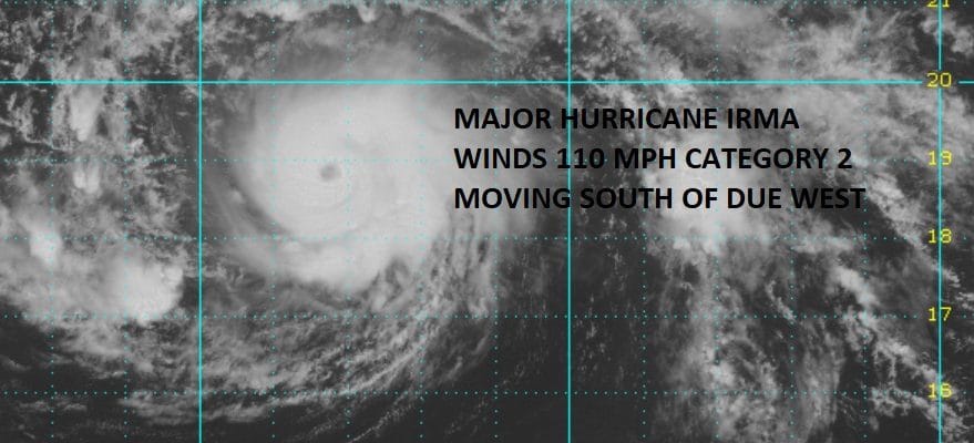
HURRICANE IRMA MIDDAY UPDATE

It appears that Irma is undergoing another round of strengthening and the motion is definitely south of west based on the satellite loop. The eye has come back. The storm actually looks less ragged and more symetrical again. The outflow is excellent as is the inflow and there is no sign of any important wind shear issues. The west southwest motion will set the stage for how big a threat is (if any) to the Northern Leeward Islands.
…IRMA MOVING WESTWARD ACROSS THE ATLANTIC AS A SMALL HURRICANE…
SUMMARY OF 1100 AM AST…1500 UTC…INFORMATION
———————————————–
LOCATION…18.8N 43.3W
ABOUT 1220 MI…1965 KM E OF THE LEEWARD ISLANDS
MAXIMUM SUSTAINED WINDS…110 MPH…175 KM/H
PRESENT MOVEMENT…W OR 265 DEGREES AT 15 MPH…24 KM/H
MINIMUM CENTRAL PRESSURE…973 MB…28.74 INCHES
WATCHES AND WARNINGS
——————–
There are no coastal watches or warnings in effect.
Interests in the northern Leeward Islands should monitor the
progress of this system.
DISCUSSION AND 48-HOUR OUTLOOK
——————————
At 1100 AM AST (1500 UTC), the eye of Hurricane Irma was located
near latitude 18.8 North, longitude 43.3 West. Irma is moving toward
the west near 15 mph (24 km/h) and a turn toward the west-southwest
at a slightly slower rate of speed during the next two days.
Maximum sustained winds are near 110 mph (175 km/h) with higher
gusts. Some strengthening is forecast during the next 48 hours.
Irma is a small hurricane. Hurricane-force winds extend outward up
to 25 miles (35 km) from the center and tropical-storm-force winds
extend outward up to 70 miles (110 km).
The estimated minimum central pressure is 973 mb (28.74 inches).
HAZARDS AFFECTING LAND
———————-
None
 GET JOE A CIGAR IF YOU LIKE

FiOS1 News Weather Forecast For Long Island
FiOS1 News Weather Forecast For New Jersey
FiOS1 News Weather Forecast For Hudson Valley


