Irma Moving West Gradual Strengthening Next Several Days
Irma Moving West Gradual Strengthening Next Several Days
Overnight Irma has weakened a bit but it seems like the eye is making a comeback again this morning. Irma is approaching 45 degrees west which is the boundary where water temperatures increase to above 82 degrees. This and a favorable upper air environment suggest that strengthening could begin again soon. Irma is forecast to remain a major hurricane for the next several days and beyond

Following the track of the developing eye indicates that Irma has now begun a southwest motion and this is critical development. How far south Irma gets will determine the extent of any threat to the Leeward Islands. Irma is a little over 1000 miles east of the Leeward Islands at the moment.

The upper low in the South Central Atlantic continues to lift northward. The amount of dry air ahead of Irma is diminishing and it does not appear to be a hostile upper air wind environment with a light wind shear environment forecast.

…IRMA CONTINUES TO FLUCTUATE IN STRENGTH BUT REMAINS A POWERFUL
HURRICANE…
SUMMARY OF 500 AM AST…0900 UTC…INFORMATION
———————————————-
LOCATION…19.0N 41.8W
ABOUT 1320 MI…2120 KM E OF THE LEEWARD ISLANDS
MAXIMUM SUSTAINED WINDS…110 MPH…175 KM/H
PRESENT MOVEMENT…W OR 270 DEGREES AT 14 MPH…22 KM/H
MINIMUM CENTRAL PRESSURE…970 MB…28.65 INCHES
WATCHES AND WARNINGS
——————–
There are no coastal watches or warnings in effect.
Interests in the northern Leeward Islands should monitor the
progress of this system.
DISCUSSION AND 48-HOUR OUTLOOK
——————————
At 500 AM AST (0900 UTC), the center of Hurricane Irma was located
near latitude 19.0 North, longitude 41.8 West. Irma is moving toward
the west near 14 mph (22 km/h). A west-southwest motion is
expected during the next couple of days.
Maximum sustained winds are near 110 mph (175 km/h) with higher
gusts. Fluctuations in strength, up or down, are possible during
the next couple of days, but Irma is expected to remain a powerful
hurricane into early next week.
Hurricane-force winds extend outward up to 25 miles (35 km) from the
center and tropical-storm-force winds extend outward up to 70 miles
(110 km).
The estimated minimum central pressure is 970 mb (28.65 inches).
HAZARDS AFFECTING LAND
———————-
None
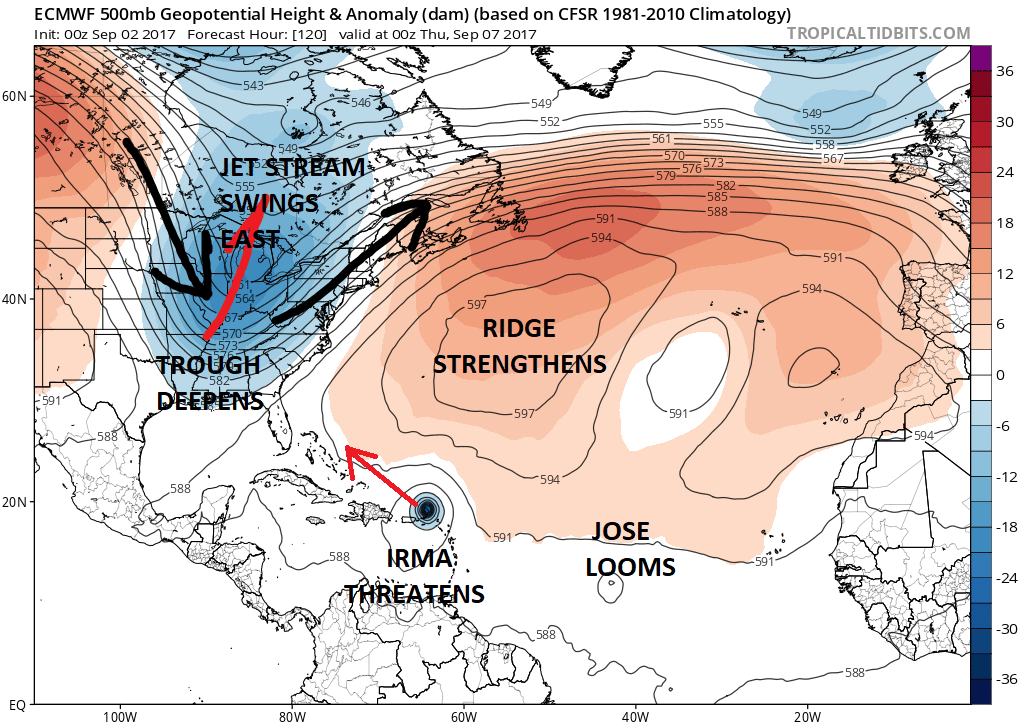
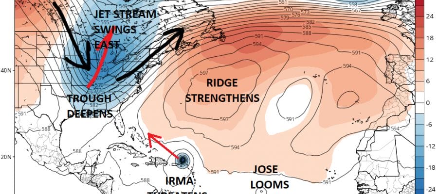
Timing appears to be the critical issue going forward. Both the European and the GFS models wind up with similar ideas 2 days apart but for different reasons. The European and GFS get stream at next Friday night are roughly in the same position. The difference is that the GFS accelerates Irma into that trough before the trough lifts up while the European lifts the trough out and Irma heads to the Southeast Coast of the US much more slowly. The GFS would suggest a threat for the East Coast beginning a week from today while the European would be Monday Tuesday. Usually these things wind up happening a bit faster than modeled. Since the threat on the models continues to remain in what I view as the long range I am going to remain agnostic for a bit longer. It appears that the threat for the US East coast is increasing a bit and my general perception since yesterday has been something somewhere from Chesapeake Bay to Savannah Ga with the higher risk and that is where I’m going to stay at this point. There is no cause for any immediate concern. Enjoy the holiday weekend in the meantime.
MANY THANKS TO TROPICAL TIDBITS FOR THE WONDERFUL USE OF THE MAPS
JOESTRADAMUS LATEST VIDEO ON IRMA
 GET JOE A CIGAR IF YOU LIKE

Weather App

Don’t be without Meteorologist Joe Cioffi’s weather app. It is really a meteorologist app because you get my forecasts and my analysis and not some automated computer generated forecast based on the GFS model. This is why your app forecast changes every 6 hours. It is model driven with no human input at all. It gives you an icon, a temperature and no insight whatsoever.
It is a complete weather app to suit your forecast needs. All the weather information you need is right on your phone. Android or I-phone, use it to keep track of all the latest weather information and forecasts. This weather app is also free of advertising so you don’t have to worry about security issues with your device. An accurate forecast and no worries that your device is being compromised.
Use it in conjunction with my website and my facebook and twitter and you have complete weather coverage of all the latest weather and the long range outlook. The website has been redone and upgraded. Its easy to use and everything is archived so you can see how well Joe does or doesn’t do when it comes to forecasts and outlooks.
Just click on the google play button or the apple store button on the sidebar for my app which is on My Weather Concierge. Download the app for free. Subscribe to my forecasts on an ad free environment for just 99 cents a month.
Get my forecasts in the palm of your hand for less than the cost of a cup of Joe!