Irma Showers On Radar Moving Northeast
Irma Showers On Radar Moving Northeast
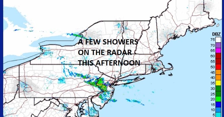
Looking at the satellite and radars this afternoon we are seeing an arm of moisture rotating northward around the circulation of the remnant Irma low in the Ohio valley. That means we have to throw in the chance for some showers but they should stay from NYC westward as they are moving to the north. Hurricane Jose is sitting between the Bahamas and Bermuda. Otherwise we are seeing clouds and some sunshine from NYC east to Long Island and north to the Hudson Valley and Connecticut at least for now.
SATELLITE LOOP

REGIONAL RADAR

LOCAL RADAR NEW YORK CITY

LOCAL RADAR PHILADELPHIA


Going into this evening some areas could get clipped by these showers as they head northeast. There isn’t anything showing up behind them so once they are done it should be rain free overnight. The core circulation of Irma will be stretching and weakening on Thursday but there will be showers or a thunderstorm around under warm and humid conditions. Temperatures this afternoon are in the upper 70s to around 80 on average and we will be in the upper 70s to lower 80s on Thursday. Friday morning could see a few lingering showers before we go to a mix of sun and clouds. Highs will be into the 80s. Then the weekend is still on course to be nice sunny and on the warm side with highs in the upper 70s and lower 80s.
Hurricane Jose is not doing much this afternoon. Winds are 75 mph with little change in strength forecast for the next 24 hours. We will evaluate the afternoon weather model package and report on this later today.
…JOSE MOVING SLOWLY SOUTHEASTWARD WITH LITTLE CHANGE IN
STRENGTH…
SUMMARY OF 1100 AM AST…1500 UTC…INFORMATION
———————————————–
LOCATION…25.5N 65.6W
ABOUT 510 MI…815 KM ENE OF THE SOUTHEASTERN BAHAMAS
ABOUT 470 MI…760 KM S OF BERMUDA
MAXIMUM SUSTAINED WINDS…75 MPH…120 KM/H
PRESENT MOVEMENT…SE OR 140 DEGREES AT 7 MPH…11 KM/H
MINIMUM CENTRAL PRESSURE…985 MB…29.09 INCHES
WATCHES AND WARNINGS
——————–
CHANGES WITH THIS ADVISORY:
None.
SUMMARY OF WATCHES AND WARNINGS IN EFFECT:
There are no coastal watches or warnings in effect.
DISCUSSION AND 48-HOUR OUTLOOK
——————————
At 1100 AM AST (1500 UTC), the center of Hurricane Jose was located
near latitude 25.5 North, longitude 65.6 West. Jose is moving
toward the southeast near 7 mph (11 km/h), but it is expected to
make a slow clockwise loop during the next couple of days, moving
west-northwestward by late Thursday.
Maximum sustained winds remain near 75 mph (120 km/h) with higher
gusts. Little change in strength is forecast during the next 48
hours.
Hurricane-force winds extend outward up to 25 miles (35 km) from the
center and tropical-storm-force winds extend outward up to 140 miles
(220 km).
The estimated minimum central pressure is 985 mb (29.09 inches).
HAZARDS AFFECTING LAND
———————-
None
JOESTRADAMUS GOES OVER THE OVERNIGHT WEATHER MODELS WITH HURRICANE JOSE.
 GET JOE A CIGAR IF YOU LIKE

FiOS1 News Weather Forecast For Long Island
FiOS1 News Weather Forecast For New Jersey
FiOS1 News Weather Forecast For Hudson Valley


