Irma Moving Toward Leewards Our Weather Relatively Calm

Irma Moving Toward Leewards Our Weather Relatively Calm
IRMA NOW CATEGORY 4 HURRICANE: WINDS 130 MPH
Irma continues on a course south of west as it heads toward the Northern Leeward Islands. Hurricane Warnings are posted for those islands. Hurricane Watches continue for the Virgin Islands and Puerto Rico. The latest Air Force plane found winds at flight level of over 121 knots. Further strengthening is forecast as conditions remain favorable.
…IRMA STRENGTHENS AS IT HEADS TOWARD THE LEEWARD ISLANDS…
…PREPARATIONS WITHIN THE WARNING AREA SHOULD BE RUSHED TO
COMPLETION…
SUMMARY OF 500 PM AST…2100 UTC…INFORMATION
———————————————-
LOCATION…16.7N 54.4W
ABOUT 490 MI…790 KM E OF THE LEEWARD ISLANDS
MAXIMUM SUSTAINED WINDS…130 MPH…215 KM/H
PRESENT MOVEMENT…W OR 265 DEGREES AT 13 MPH…20 KM/H
MINIMUM CENTRAL PRESSURE…944 MB…27.88 INCHES
WATCHES AND WARNINGS
——————–
CHANGES WITH THIS ADVISORY:
The government of France has issued a Tropical Storm Warning for
Guadeloupe.
SUMMARY OF WATCHES AND WARNINGS IN EFFECT:
A Hurricane Warning is in effect for…
* Antigua, Barbuda, Anguilla, Montserrat, St. Kitts, and Nevis
* Saba, St. Eustatius, and Sint Maarten
* Saint Martin and Saint Barthelemy
A Hurricane Watch is in effect for…
* Guadeloupe
* British Virgin Islands
* U.S. Virgin Islands
* Puerto Rico, Vieques, and Culebra
A Tropical Storm Warning is in effect for…
* Guadeloupe
A Tropical Storm Watch is in effect for…
* Dominica
SATELLITE LOOP

Our weather by contrast was spectacular for Labor Day with almost cloud free skies and temperatures in the upper 70s and lower 80s. The satellite loop shows cloud free conditions for tonight with temperatures in the 60s to near 70. There are no showers anywhere close so go forward with all outdoor activities.
REGIONAL RADAR

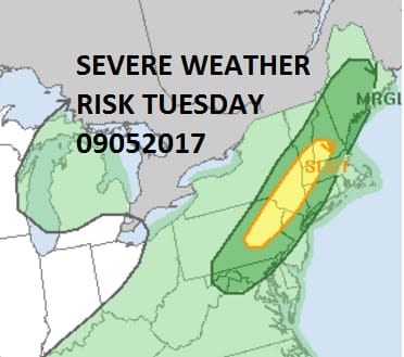
Tuesday will be one last summer day and it will be very warm and humid as highs reach the mid to upper 80s. A cold front will be approaching with the chance for thunderstorms Tuesday late afternoon and evening. The Storm Prediction Center has our area at a risk for severe weather Tuesday evening.

The front will get hung up for awhile on Wednesday so there will be some clouds and a few lingering showers. Temperatures Wednesday will be significantly cooler with highs just in the 70s. High pressure begins to build in Thursday assuming the front gets moving again and we should see a mix of sun and clouds Thursday and mostly sunny skies Friday and possibly the weekend. If Hurricane Irma (and its a big if) were to have some impact here it would not happen until early next week.
 GET JOE A CIGAR IF YOU LIKE

FiOS1 News Weather Forecast For Long Island
FiOS1 News Weather Forecast For New Jersey
FiOS1 News Weather Forecast For Hudson Valley


