Irma Risks Grow Florida, Bahamas Southeast US

Irma Risks Grow Florida, Bahamas Southeast US
There is still a tremendous amount of uncertainty that exist going forward regarding Hurricane Irma. First off lets start with what is going on now.
…IRMA CONTINUES TO MOVE WEST-SOUTHWESTWARD TOWARD THE
LEEWARD ISLANDS…
SUMMARY OF 200 PM AST…1800 UTC…INFORMATION
———————————————-
LOCATION…16.7N 53.8W
ABOUT 530 MI…850 KM E OF THE LEEWARD ISLANDS
MAXIMUM SUSTAINED WINDS…120 MPH…195 KM/H
PRESENT MOVEMENT…WSW OR 255 DEGREES AT 14 MPH…22 KM/H
MINIMUM CENTRAL PRESSURE…944 MB…27.88 INCHES
WATCHES AND WARNINGS
——————–
CHANGES WITH THIS ADVISORY:
None
SUMMARY OF WATCHES AND WARNINGS IN EFFECT:
A Hurricane Warning is in effect for…
* Antigua, Barbuda, Anguilla, Montserrat, St. Kitts, and Nevis
* Saba, St. Eustatius, and Sint Maarten
* Saint Martin and Saint Barthelemy
A Hurricane Watch is in effect for…
* Guadeloupe
* British Virgin Islands
* U.S. Virgin Islands
* Puerto Rico, Vieques, and Culebra
A Tropical Storm Watch is in effect for…
* Dominica

Irma going forward is going thread a very fine needle. The graphic above from Tropical Tidbits is the most recent aircraft report with a pressure of 944 mb which is down 16 millibars from last night. This round of strengthening appears to have leveled off for the time being but this could be another one of those eye wall replacement cycles. Conditions favor further strengthening and Irma could be a category 4 hurricane when it makes its closest pass to the Leeward Islands on Tuesday.Recent satellite loops show that the motion this afternoon has been more westerly which could be the end of the west south west motion but lets wait a few more hours to make sure the westerly course is the new heading.

The hurricane model guidance is well clustered with most of the models taking a track just north of the Virgin Islands, Puerto Rico, and the Dominican Republic and the the eye gets very close to the north coast of Cuba. From there a slow right turn should commence with a majority of the models including all the global models bringing Irma in South or Southeast Florida over the weekend. From here the track becomes a bit more muddied as the upper air jet stream pattern remains very volatile and sensitive to even the slightest adJustment north or south.
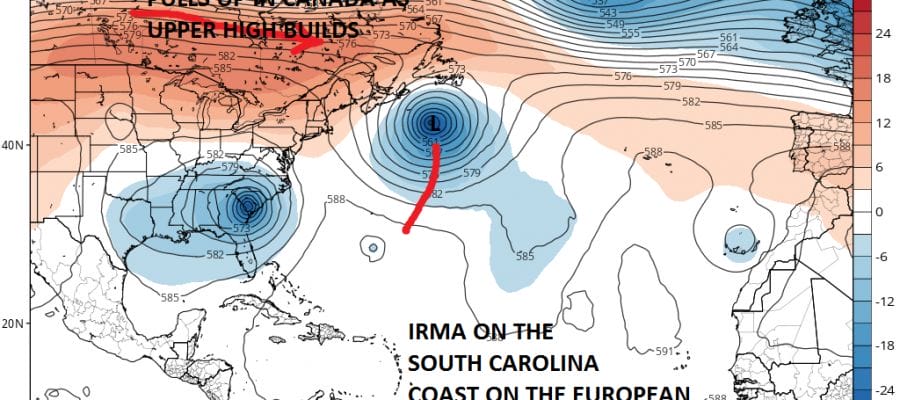
EUROPEAN UPPER AIR FORECAST NEXT TUESDAY SEPTEMBER 12, 2017

After a brief hiccup yesterday the European for the last 2 runs has come around to the idea of Irma missing any opportunity to turn northeastward out to sea (though that option is not completely off the table, the door is closing fast). It joins the other models which have a similar look. This would argue for a second landfall somewhere along the southeast coast early next week. However it is not completely clear cut. There may be another option that has appeared. The European profile would hook Irma northwestward toward the Ohio Valley. On the European, the risks for the Northeast & Northern Middle Atlantic States would be minimal.
GFS UPPER AIR FORECAST TUESDAY SEPTEMBER 12
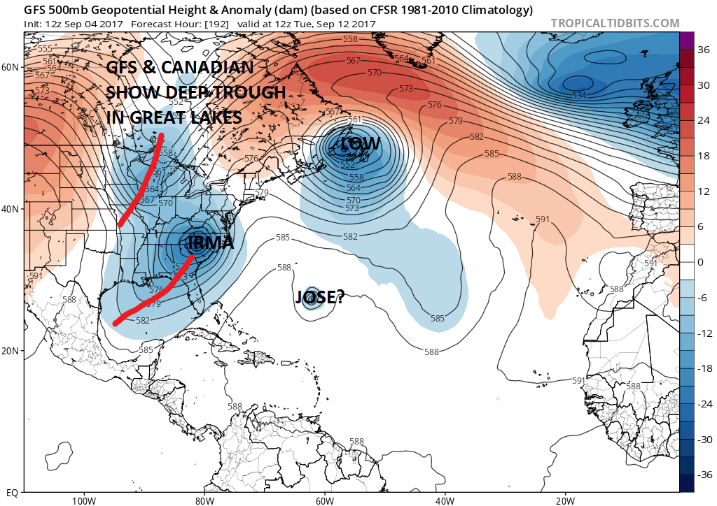
The GFS and the Canadian model however have other ideas. Notice that the GFS has a very deep trough in the Great Lakes diving southward. The European does not have this at all. This option would take Irma inland along the Southeast coast (or further north) and then bring in northward up the coast either along or just west of the Appalachians. This opens up other possibilites where there would be some impact to the Middle Atlantic & Northeast, The Canadian has land fall back in Chesapeake Bay while the GFS would have a landfall in Southwestern South Carolina with transitions into a major post tropical storm that heads into Western Pennsylvania.
Based on what we are seeing today, I still think that there is risk up and down the East Coast but for the Northern Middle Atlantic and Northeast the risk of a direct hit has diminished somewhat. At the same time the risk for the Southeast Coast from North Carolina to George is higher. I’m tending to discount the Canadian models idea for the time being.
The balance in the upper atmosphere is extremely fragile. If the ridge off the Southeast Coast of the US is a little weaker than modeled, then this could create a turn to the north sooner in which case it opens up a number of other possibility including an out to sea solution. Stay tuned folks. We are not closer to the solution to this very complex setup.
MANY THANKS TO TROPICAL TIDBITS FOR THE WONDERFUL USE OF THE MAPS

GET JOE A CIGAR IF YOU LIKE!
FiOS1 News Weather Forecast For Long Island
FiOS1 News Weather Forecast For New Jersey
FiOS1 News Weather Forecast For Hudson Valley
NATIONAL WEATHER SERVICE SNOW FORECASTS
LATEST JOESTRADAMUS ON THE LONG RANGE
Weather App

Don’t be without Meteorologist Joe Cioffi’s weather app. It is really a meteorologist app because you get my forecasts and my analysis and not some automated computer generated forecast based on the GFS model. This is why your app forecast changes every 6 hours. It is model driven with no human input at all. It gives you an icon, a temperature and no insight whatsoever.
It is a complete weather app to suit your forecast needs. All the weather information you need is right on your phone. Android or I-phone, use it to keep track of all the latest weather information and forecasts. This weather app is also free of advertising so you don’t have to worry about security issues with your device. An accurate forecast and no worries that your device is being compromised.
Use it in conjunction with my website and my facebook and twitter and you have complete weather coverage of all the latest weather and the long range outlook. The website has been redone and upgraded. Its easy to use and everything is archived so you can see how well Joe does or doesn’t do when it comes to forecasts and outlooks.
Just click on the google play button or the apple store button on the sidebar for my app which is on My Weather Concierge. Download the app for free. Subscribe to my forecasts on an ad free environment for just 99 cents a month.
Get my forecasts in the palm of your hand for less than the cost of a cup of Joe!