Irma Hurricane Warnings Northern Leewards Watch Virgin Islands Puerto Rico
Irma Hurricane Warnings Northern Leewards
Hurricane Watch Virgin Islands Puerto Rico
Risk Bahamas Florida Increasing
Hurricane Irma 120 mph winds Category 3 hurricane continues on a west southwest course. The hurricane has become better organized and continues to strengthen. Winds are now 120 mph. An Air Force plane is investigating Irma right now. Hurricane Warnings are now up for the Northern Leeward Islands with a Hurricane Watch for the Virgin Islands and Puerto Rico.
.
SATELLITE LOOP

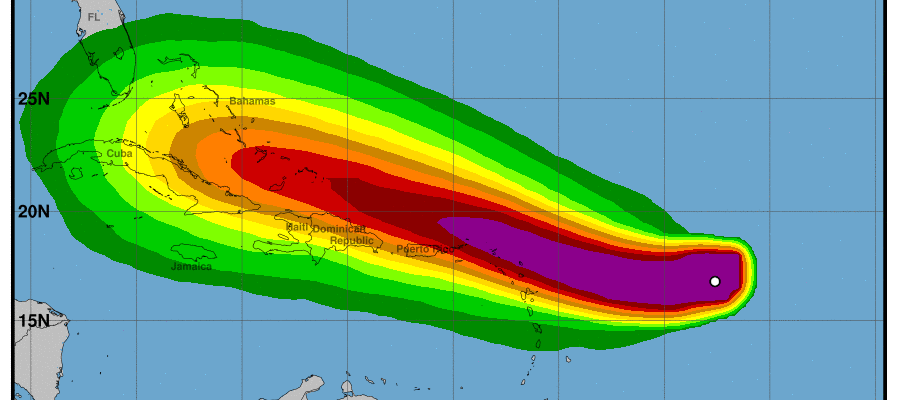
…HURRICANE WARNINGS ISSUED FOR PORTIONS OF THE LEEWARD ISLANDS…
…HURRICANE WATCHES ISSUED FOR THE BRITISH AND U.S. VIRGIN ISLANDS
AND PUERTO RICO…
SUMMARY OF 1100 AM AST…1500 UTC…INFORMATION
———————————————–
LOCATION…16.8N 53.3W
ABOUT 560 MI…905 KM E OF THE LEEWARD ISLANDS
MAXIMUM SUSTAINED WINDS…120 MPH…195 KM/H
PRESENT MOVEMENT…WSW OR 255 DEGREES AT 14 MPH…22 KM/H
MINIMUM CENTRAL PRESSURE…944 MB…27.88 INCHES
WATCHES AND WARNINGS
——————–
CHANGES WITH THIS ADVISORY:
The government of Antigua has issued a Hurricane Warning for the
islands of Antigua, Barbuda, Anguilla, Montserrat, St. Kitts, and
Nevis. A Hurricane Watch has been issued for the British Virgin
Islands.
The government of the Netherlands has issued a Hurricane Warning for
the islands of Saba, St. Eustatius, and Sint Maarten.
The government of France has issued a Hurricane Warning for St.
Martin and Saint Barthelemy. A Hurricane Watch has been issued for
Guadeloupe.
A Hurricane Watch has been issued for the U.S. Virgin Islands,
Puerto Rico, Vieques, and Culebra.
The government of Barbados has issued a Tropical Storm Watch for
Dominica.
SUMMARY OF WATCHES AND WARNINGS IN EFFECT:
A Hurricane Warning is in effect for…
* Antigua, Barbuda, Anguilla, Montserrat, St. Kitts, and Nevis
* Saba, St. Eustatius, and Sint Maarten
* Saint Martin and Saint Barthelemy
A Hurricane Watch is in effect for…
* Guadeloupe
* British Virgin Islands
* U.S. Virgin Islands
* Puerto Rico, Vieques, and Culebra
A Tropical Storm Watch is in effect for…
* Dominica
A Hurricane Warning means that hurricane conditions are expected
somewhere within the warning area. A warning is typically issued
36 hours before the anticipated first occurrence of tropical-storm-
force winds, conditions that make outside preparations difficult or
dangerous. Preparations to protect life and property should be
rushed to completion.
A Hurricane Watch means that hurricane conditions are possible
within the watch area. A watch is typically issued 48 hours before
the anticipated first occurrence of tropical-storm-force winds,
conditions that make outside preparations difficult or dangerous.
A Tropical Storm Watch means that tropical storm conditions are
possible within the watch area, generally within 48 hours.
Interests in the Dominican Republic, Haiti, the Turks and Caicos
Islands, and the southeastern Bahamas should monitor the progress of
Irma.
For storm information specific to your area in the United States,
including possible inland watches and warnings, please monitor
products issued by your local National Weather Service forecast
office. For storm information specific to your area outside the
United States, please monitor products issued by your national
meteorological service.
DISCUSSION AND 48-HOUR OUTLOOK
——————————
At 1100 AM AST (1500 UTC), the eye of Hurricane Irma was located
near latitude 16.8 North, longitude 53.3 West. Irma is moving toward
the west-southwest near 14 mph (22 km/h). A turn toward the west
is expected later today, followed by a west-northwestward turn late
Tuesday. On the forecast track, the center of Irma will move near
or over portions of the northern Leeward Islands Tuesday night
and early Wednesday.
Maximum sustained winds are near 120 mph (195 km/h) with higher
gusts. Irma is a category 3 hurricane on the Saffir-Simpson
Hurricane Wind Scale. Additional strengthening is forecast through
Tuesday night.
Hurricane-force winds extend outward up to 35 miles (55 km) from the
center and tropical-storm-force winds extend outward up to 140 miles
(220 km).
The estimated minimum central pressure based on data from a NOAA
Hurricane Hunter aircraft is 944 mb (27.88 inches).
HAZARDS AFFECTING LAND
———————-
STORM SURGE: The combination of a dangerous storm surge and large
breaking waves will raise water levels by as much as 6 to 9 feet
above normal tide levels along the coasts of the extreme northern
Leeward Islands within the hurricane warning area near and to the
north of the center of Irma. Near the coast, the surge will be
accompanied by large and destructive waves.
WIND: Hurricane conditions are expected within the hurricane
warning area by Tuesday night, with tropical storm conditions
expected by late Tuesday. Hurricane conditions are possible within
the hurricane watch area by late Wednesday, with tropical storm
conditions possible by early Wednesday.
RAINFALL: Irma is expected to produce total rainfall accumulations
of 3 to 6 inches across the Leeward Islands, with isolated maximum
amounts of 10 inches across the northern Leeward Islands. These
rainfall amounts may cause life-threatening flash floods and
mudslides.
SURF: Swells generated by Irma will affect the northern Leeward
Islands during the next several days. These swells are likely to
cause life-threatening surf and rip current conditions. Please
consult products from your local weather office.
SATELLITE LOOP

As far as our weather is concerned we are enjoying a beautiful late summer day on this Labor Day with sunshine and temperatures into the 80s for the afternoon highs. There is no rain anywhere close and very little cloud cover. There are no weather issues to speak of on this last day of the holiday weekend.
REGIONAL RADAR

LOCAL RADAR NEW YORK CITY

LOCAL RADAR PHILADELPHIA


Tonight will be a warm night with lows in the 60s to near 70 with nothing more than a few passing clouds. Tuesday looks to be very warm with sunshine and highs in the mid to upper 80s. Then a cold front approaches on Wednesday with the chance for showers and thunderstorms. That front starts to set in motion the mechanisms that will determine the fate of Hurricane Irma.
 GET JOE A CIGAR IF YOU LIKE

FiOS1 News Weather Forecast For Long Island
FiOS1 News Weather Forecast For New Jersey
FiOS1 News Weather Forecast For Hudson Valley


