Hurricane Irma Category 3 120 MPH Hurricane Watch Leeward Islands
Hurricane Irma Category 3 120 MPH
Hurricane Watch Leeward Islands

Hurrricane Watch continues for the Leeward Islands and warnings will like be required later today. Watches and Warnings are likely to be extended westward to the Virgin Islands and Puerto Rico as well. Hurricane Irma is a major hurricane with maximum sustained winds of 120 mph. The motion to the west southwest continues this morning and as the hurricane loses latitude it increases the risk to the entire Greater Antilles chain. The outflow of the hurricane is improving as the overall presentation. Irma seems to be growing in size as well.

…NOAA HURRICANE HUNTER AIRCRAFT FINDS IRMA A LITTLE STRONGER…
SUMMARY OF 800 AM AST…1200 UTC…INFORMATION
———————————————-
LOCATION…16.8N 52.6W
ABOUT 610 MI…980 KM E OF THE LEEWARD ISLANDS
MAXIMUM SUSTAINED WINDS…120 MPH…195 KM/H
PRESENT MOVEMENT…WSW OR 255 DEGREES AT 14 MPH…22 KM/H
MINIMUM CENTRAL PRESSURE…947 MB…27.96 INCHES
WATCHES AND WARNINGS
——————–
CHANGES WITH THIS ADVISORY:
None.
SUMMARY OF WATCHES AND WARNINGS IN EFFECT:
A Hurricane Watch is in effect for…
* Antigua, Barbuda, Anguilla, Montserrat, St. Kitts, and Nevis
* Saba, St. Eustatius, and Sint Maarten
* Saint Martin and Saint Barthelemy
A Hurricane Watch means that hurricane conditions are possible
within the watch area. A watch is typically issued 48 hours before
the anticipated first occurrence of tropical-storm-force winds,
conditions that make outside preparations difficult or dangerous.
Interests in the remainder of the Leeward Islands, the British and
U.S. Virgin Islands, Puerto Rico, and the Dominican Republic should
monitor the progress of Irma. Additional hurricane and tropical
storm watches and warnings will likely be required for portions of
this area later this morning or this afternoon.
For storm information specific to your area, please monitor products
issued by your national meteorological service.
DISCUSSION AND 48-HOUR OUTLOOK
——————————
At 800 AM AST (1200 UTC), the eye of Hurricane Irma was located near
latitude 16.8 North, longitude 52.6 West. Irma is moving toward the
west-southwest near 14 mph (22 km/h). A turn toward the west is
expected later today, followed by a west-northwestward turn late
Tuesday. On the forecast track, the center of Irma will move closer
to the Leeward Islands through Tuesday and then be near the northern
Leeward Islands Tuesday night.
Data from a NOAA Hurricane Hunter aircraft indicate that the
maximum sustained winds have increased to near 120 mph (195 km/h)
with higher gusts. Irma is a category 3 hurricane on the
Saffir-Simpson Hurricane Wind Scale. Additional strengthening is
forecast through Tuesday night.
Hurricane-force winds extend outward up to 30 miles (45 km) from
the center, and tropical-storm-force winds extend outward up to 140
miles (220 km).
The latest minimum central pressure estimated from data received by
the reconnaissance aircraft is 947 mb (27.96 inches).
HAZARDS AFFECTING LAND
———————-
WIND: Hurricane conditions are possible within the watch area by
Tuesday night, with tropical storm conditions possible by late
Tuesday.
SURF: Swells generated by Irma will begin affecting the northern
Leeward Islands today. These swells are likely to cause life-
threatening surf and rip current conditions. Please consult
products from your local weather office.

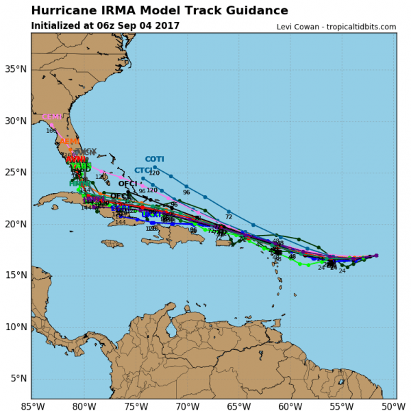
Going forward weather models overnight continue to shift westward and southward in both the short and the long range. The upper high to the north continues to be the primary driver of Irma with no weakness in the ridge being shown that would allow Irma to turn more northward. Hurricane models remain remarkably tightly clustered, coming very close to each of the Islands from the Northern leewards to Cuba. Toward the end of the forecast period a gradual turn to the north is indicated.
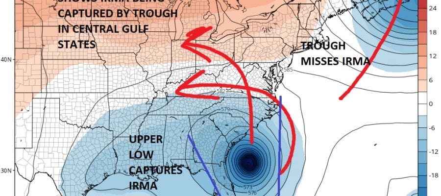
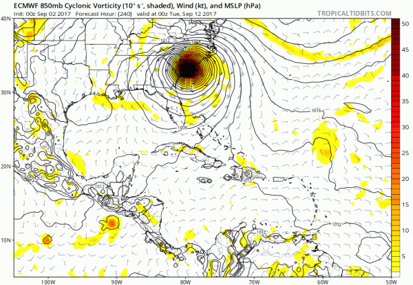
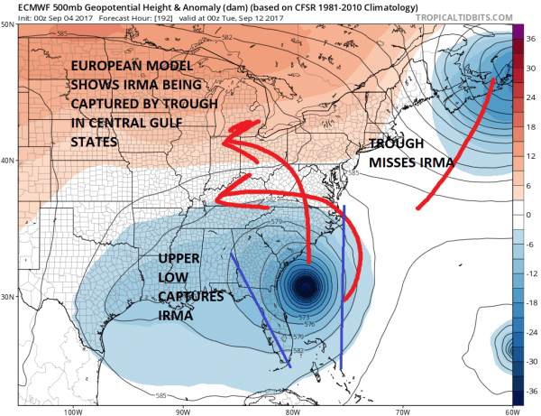
Models continue to take longer and longer to make the right turn northward. The European model which was the furthest east of all the models yesterday is the furthest east today however the hurricane gets captured but the troughing in the Gulf States and swings the hurricane northward just east of the Floriday coast to the Carolinas.
EUROPEAN MODEL RUN TREND LAST 5 RUNS CLICK TO ANMIATE
With the European model the trend in the last few runs has been to be the furthest east along the east coast with 2 runs showing out to sea. The latest runs comes in westward. The European model as with the others, shows Irma being captured by a developing trough and upper low in the Central Gulf States and rotating around it. The blue lines indicate the range of the global models with their tracks.
Since they seem to be on the same page at the moment lets see if we can get them to get a little closer on their paths. The GFS & Canadian take Irma over Florida the long way from south to north. The European takes it just off the Florida east coast. Still lots of uncertainty in the long range but the westward and southern trends seem to be well established and that at least gives increasing confidence inside the 5 day period. It would also be fair to say that the risk to the Bahamas is increasing since they could see Irma by late week.
MANY THANKS TO TROPICAL TIDBITS FOR THE WONDERFUL USE OF THE MAPS
 GET JOE A CIGAR IF YOU LIKE
Weather App
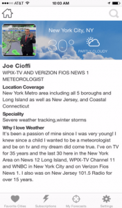
Don’t be without Meteorologist Joe Cioffi’s weather app. It is really a meteorologist app because you get my forecasts and my analysis and not some automated computer generated forecast based on the GFS model. This is why your app forecast changes every 6 hours. It is model driven with no human input at all. It gives you an icon, a temperature and no insight whatsoever.
It is a complete weather app to suit your forecast needs. All the weather information you need is right on your phone. Android or I-phone, use it to keep track of all the latest weather information and forecasts. This weather app is also free of advertising so you don’t have to worry about security issues with your device. An accurate forecast and no worries that your device is being compromised.
Use it in conjunction with my website and my facebook and twitter and you have complete weather coverage of all the latest weather and the long range outlook. The website has been redone and upgraded. Its easy to use and everything is archived so you can see how well Joe does or doesn’t do when it comes to forecasts and outlooks.
Just click on the google play button or the apple store button on the sidebar for my app which is on My Weather Concierge. Download the app for free. Subscribe to my forecasts on an ad free environment for just 99 cents a month.
Get my forecasts in the palm of your hand for less than the cost of a cup of Joe!

