
Independence Day Holiday Weekend Getaway Day
Independence Day Holiday Weekend Getaway Day
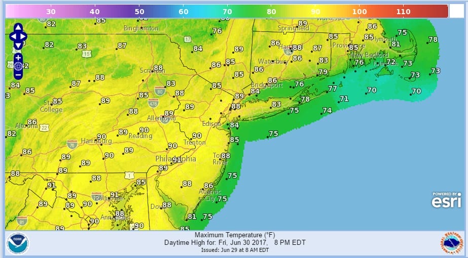
We are seeing the return of humidity today to some degree although it still hasn’t really penetrated to truly oppressive levels. Some clouds are in the mix this morning but we should see some sun break through the clouds. The next few days will be very warm to hot but not oppressively hot and certainly not anything record breaking or even record challenging. Highs today will reach the upper 80s to lower 90s but if you have a south facing coast line the south south west wind will keep temperatures lower with highs just in the lower to perhaps middle 80s if you are far enough away from the shore. Right along the immediate coast the next 2 days it will be in the 70s.
There are some showers on the radar this morning to the north of our area and the risk is there late this afternoon for a scattered shower or thunderstorm mainly away from coastal areas. Other than that there should be no issues to wherever you many be travelling inside the geographic zone of the map above.
SATELLITE LOOP

REGIONAL RADAR

LOCAL RADAR NEW YORK CITY

LOCAL RADAR PHILADELPHIA


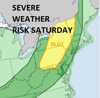
There are no real changes in the forecast outlook for the next several days from what we discussed yesterday. Of all the days coming up Saturday has the best chance for widespread thunderstorm activity late in the day and Saturday night as a cold front comes through. The Storm Prediction Center outlines a large area at a slight risk for severe weather.
Much of the day side Saturday should be okay with the main threat later in the afternoon and at night. Sunday looks good. Monday a thunderstorm risk later in the day. Tuesday Independence Day dry sunshine and temperatures all weekend into Tuesday mostly in the 80s to near 90 in warm spots.
For more details on each day click on this JOESTRADAMUS post.
 GET JOE A CIGAR IF YOU LIKE

Weather App

Don’t be without Meteorologist Joe Cioffi’s weather app. It is really a meteorologist app because you get my forecasts and my analysis and not some automated computer generated forecast based on the GFS model. This is why your app forecast changes every 6 hours. It is model driven with no human input at all. It gives you an icon, a temperature and no insight whatsoever.
It is a complete weather app to suit your forecast needs. All the weather information you need is right on your phone. Android or I-phone, use it to keep track of all the latest weather information and forecasts. This weather app is also free of advertising so you don’t have to worry about security issues with your device. An accurate forecast and no worries that your device is being compromised.
Use it in conjunction with my website and my facebook and twitter and you have complete weather coverage of all the latest weather and the long range outlook. The website has been redone and upgraded. Its easy to use and everything is archived so you can see how well Joe does or doesn’t do when it comes to forecasts and outlooks.
Just click on the google play button or the apple store button on the sidebar for my app which is on My Weather Concierge. Download the app for free. Subscribe to my forecasts on an ad free environment for just 99 cents a month.
Get my forecasts in the palm of your hand for less than the cost of a cup of Joe!


