Hurricane Watch Tropical Storm Eta Warnings South Florida Including The Keys Winds 60 MPH Heavy Rains

Weather in 5/Joe & Joe Weather Show Latest Podcast
Hurricane Watch Tropical Storm Eta Warnings South Florida Including The Keys Winds 60 MPH Heavy Rains
Tropical Storm Eta has been organizing this afternoon in spite of having to deal with strong vertical wind shear which is hostile to development. This gives the circulation a bit of a tilt and keeps the western part of the storm far less active than the east and northeast. However the storm is responding to very warm water temperatures in the Caribbean which is compensating somewhat from the relatively hostile environment.
4PM LOCATION…20.4N 80.7W
ABOUT 195 MI…310 KM WSW OF CAMAGUEY CUBA
MAXIMUM SUSTAINED WINDS…60 MPH…95 KM/H
PRESENT MOVEMENT…NE OR 50 DEGREES AT 16 MPH…26 KM/H
MINIMUM CENTRAL PRESSURE…994 MB…29.36 INCHES
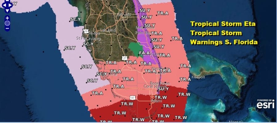
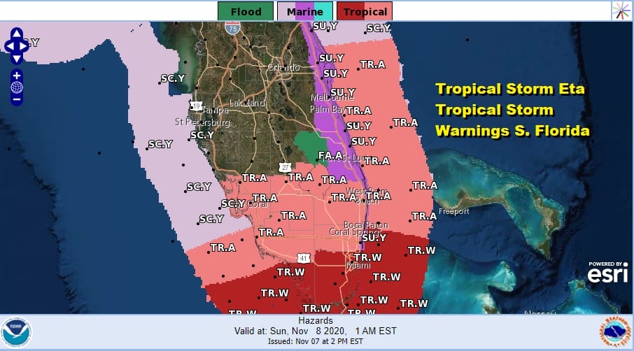
A Hurricane Watch is in effect for the coast of southern Florida from Deerfield Beach to Bonita Beach, and for the Florida Keys from Ocean Reef to the Dry Tortugas, including Florida Bay. A Tropical Storm Warning is in effect from north of Golden Beach to Jupiter Inlet, Florida, and west of Chokoloskee, Florida to Bonita Beach, Florida, including Lake Okeechobee.
SATELLITE

REGIONAL RADAR

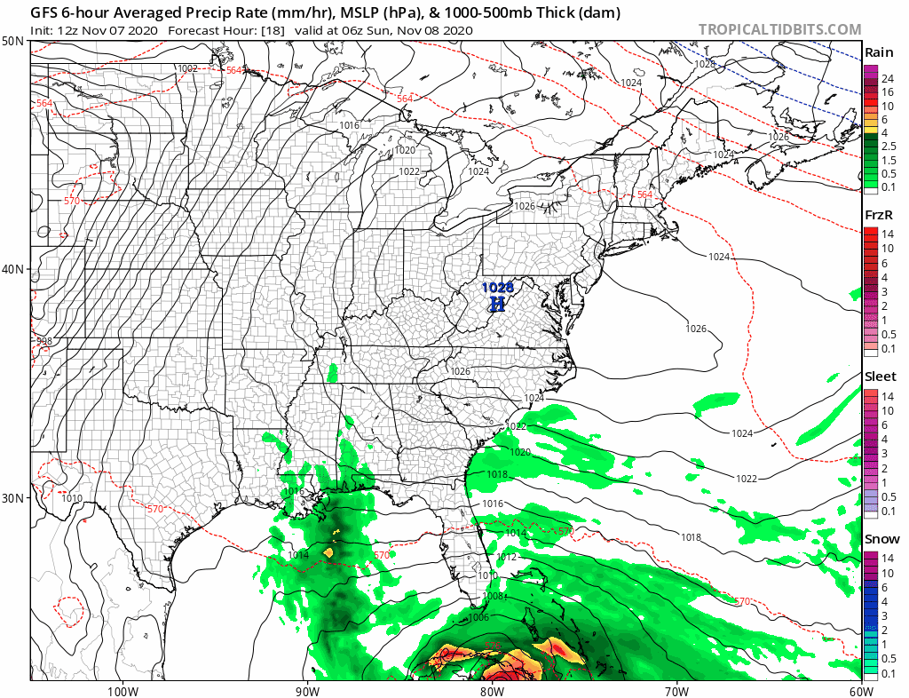
Rain bands have pushed well north of the center as you can see on the regional as well as the local South Florida radars from Miami and Key West. Echos are moving from east to west around the storms large circulation. More rain will arrive for Sunday into Monday and the heaviest rain will be north and northeast of the storm track. Winds along the East Coast of Florida are gusting to near 40 mph at times, well ahead of the storm itself. It is interacting with the tightening pressure gradient thanks to strong high pressure sitting in West Virginia. The easterly fetch extends some 2000 miles east and that will likely create tidal flooding concerns over the next few days along the Florida east coast. That wind direction from the east and northeast however will do exactly the opposite on the Florida west coast.
LOCAL RADAR MIAMI FL

LOCAL RADAR KEY WEST FL


The official forecast track of the hurricane center takes Eta to the northwest over Cuba followed by a turn to the north and then the northwest once the storm enters the Florida Straits. The track brings the center of Eta to the extreme southeastern corner of Florida Monday morning and exiting on the other side Monday evening on the west coast.
LOCAL RADAR KEY WEST FL


The storm’s circulation is large and the big high to the north in the Middle Atlantic states will keep gusty winds and gales going on along both coasts for the next 60 hours or even longer. The bigger story remains rainfall which will be on the order of at least 5 to 10 inches in South Florida with lower amounts as you head northward. Some areas in Southeast Florida could see 10-15 inches of rain from Eta.

None of this will have any impact here through the weekend and into early next week as we continue to enjoy the big high in the Middle Atlantic states making for sunshine and warm days and clear but not so chilly nights.
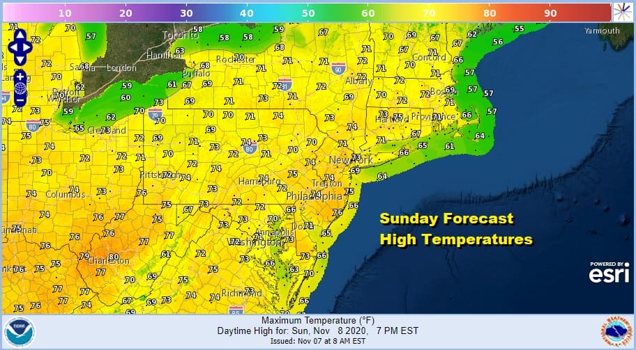
Other than some morning low clouds and fog that could develop in coastal areas and some inland valleys, our nice weather continues through Monday with highs in the low to mid 70s both Sunday and Monday and that could lead to some records being set.
The high does move out on Tuesday and that may bring in some marine moisture in the form of clouds. Also the wind will become more southerly or even southeasterly which will help the moistening process along. A cold front approaches with wide spread showers on Wednesday. Models show some of the tropical feed around Eta being drawn northward ahead of the cold front giving us a shot for a widespread rainfall of 1 to 2 inches. Eta looks to get left behind in the Gulf of Mexico on most model outcomes but it still could have a say in our weather later next week. Wednesday’s cold front will stall out and another storm to the west might carry more rain or showers northward sometime next weekend.
BE SURE TO DOWNLOAD THE FREE METEOROLOGIST JOE CIOFFI WEATHER APP &
ANGRY BEN’S FREE WEATHER APP “THE ANGRY WEATHERMAN!
MANY THANKS TO TROPICAL TIDBITS FOR THE USE OF MAPS
Please note that with regards to any severe weather, tropical storms, or hurricanes, should a storm be threatening, please consult your local National Weather Service office or your local government officials about what action you should be taking to protect life and property.


