
So far we have this from the National Hurricane Center regarding actual observations.
An unconfirmed sustained wind report of 185 mph and a gust to 211
mph was received from a NOAA/NWS Hydrometeorological Automated Data
System (HADS) elevated station (295 ft) at Chamela-Cuixmala, Mexico
near the time of landfall.  This observation should be considered
unofficial until it has been quality controlled.
Satellite and surface data indicate that the center of Patricia made
landfall at about 615 PM CDT (2315 UTC) near Cuixmala, Mexico with
maximum sustained winds estimated at 145 kt/165 mph.  Since that
time, the eye has become obscured, with a large circular area of
deep convection continuing near the center.
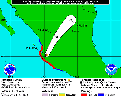
The hurricane is now well inland but it is still a category 3 storm with top winds at 130 mph as per the 10pm advisory. Weakening should continue overnight
SUMMARY OF 1000 PM CDT...0300 UTC...INFORMATION
-----------------------------------------------
LOCATION...20.2N 104.6W
ABOUT 85 MI...135 KM NNW OF MANZANILLO MEXICO
ABOUT 50 MI...75 KM SE OF PUERTO VALLARTA MEXICO
MAXIMUM SUSTAINED WINDS...130 MPH...215 KM/H
PRESENT MOVEMENT...NNE OR 20 DEGREES AT 20 MPH...31 KM/H
MINIMUM CENTRAL PRESSURE...946 MB...27.94 INCHES
The moisture feed remains impressive as the core of the circulation is still very much intact. The circulation will begin to get ripped apart by the mountains but it is moving at a pretty good clip. It will be interesting to see what survives by the time it reaches South Texas later Saturday and Saturday evening. On the other side of the Satellite loop you can see Hurricane Olaf passing well east of Hawaii and moving to the northeast.
For the latest weather discussion see my latest gfs discussion regarding Hurricane Patricia and the threat for rain here for the middle of next week.
Since the hurricane moved inland in the late afternoon and evening there have been very few reports on the extent of damage to the coastal areas. Once the sun is up we will be getting all sorts of videos and pictures regarding the devastation caused by a category 5 hurricane coming ashore.