Hurricane Matthew Begins To Turn
Hurricane Matthew Begins To Turn
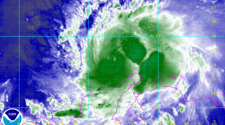
Completed Counterclockwise Loop
Warnings Up For Jamaica
Hurricane Matthew did a counterclockwise loop this afternoon and you can follow it along as long as the eye remains visible on the water vapor loop. It may be getting ready to move northwestward toward Jamaica and Haiti. Also reconnaissance reports show that pressures have fallen from 946 mb to 940 mb in the last few hours. We will see if this is the beginning of another round of strengthening or just a normal fluctuation.

..HURRICANE WARNING ISSUED FOR JAMAICA AND MUCH OF HAITI...
...MATTHEW EXPECTED TO BRING LIFE-THREATENING RAINFALL TO PORTIONS
OF HAITI...


SUMMARY OF 500 PM EDT...2100 UTC...INFORMATION
----------------------------------------------
LOCATION...13.5N 73.4W
ABOUT 360 MI...580 KM SSW OF PORT AU PRINCE HAITI
ABOUT 385 MI...620 KM SE OF KINGSTON JAMAICA
MAXIMUM SUSTAINED WINDS...150 MPH...240 KM/H
PRESENT MOVEMENT...NW OR 315 DEGREES AT 3 MPH...6 KM/H
MINIMUM CENTRAL PRESSURE...940 MB...27.76 INCHES


WATCHES AND WARNINGS
--------------------
CHANGES WITH THIS ADVISORY:

The government of Jamaica has issued a Hurricane Warning for
Jamaica.

A Hurricane Warning has been issued for Haiti from the southern
border with the Dominican Republic to Le Mole St. Nicholas

A Hurricane Watch has been issued for Haiti from east of Le Mole
St. Nicholas to the northern border with the Dominican Republic.

The Meteorological Service of Cuba has issued a Hurricane Watch for
eastern Cuba from the province of Camaguey southeastward to the
province of Guantanamo.

SUMMARY OF WATCHES AND WARNINGS IN EFFECT:

A Hurricane Warning is in effect for...
* Jamaica
* Haiti from the southern border with the Dominican Republic to
Le Mole St. Nicholas

A Hurricane Watch is in effect for...
* Haiti from east of Le Mole St. Nicholas to the northern
border with the Dominican Republic
* Cuba from Camaguey province to Guantanamo province

Interests elsewhere in Hispaniola and in the Bahamas should monitor
the progress of Matthew.  A Hurricane Watch could be needed for
portions of the Bahamas tonight or Sunday.

A Hurricane Warning means that hurricane conditions are expected
somewhere within the warning area.  A warning is typically issued 36
hours before the anticipated first occurrence of tropical-storm-
force winds, conditions that make outside preparations difficult or
dangerous.  Preparations to protect life and property should be
rushed to completion.

A Hurricane Watch means that hurricane conditions are possible
within the watch area.  A watch is typically issued 48 hours before
the anticipated first occurrence of tropical-storm-force winds,
conditions that make outside preparations difficult or dangerous.

For storm information specific to your area, please monitor products
issued by your national meteorological service.


DISCUSSION AND 48-HOUR OUTLOOK
------------------------------
At 500 PM EDT (2100 UTC), the eye of Hurricane Matthew was located
near latitude 13.5 North, longitude 73.4 West.  Matthew is currently
drifting toward the northwest near 3 mph (6 km/h), and a slow
northwestward motion is expected to continue through tonight.  A
turn toward the north-northwest with an increase in forward speed
are expected Sunday, followed by a turn toward the north on Monday.
On the forecast track, the center of Matthew will approach Jamaica
and southwestern Haiti on Monday.

Data from a NOAA Hurricane Hunter aircraft indicate that maximum
sustained winds are near 150 mph (240 km/h) with higher gusts.
Matthew is a category 4 hurricane on the Saffir-Simpson Hurricane
Wind Scale.  Some fluctuations in intensity are possible during the
next couple of days, but Matthew is expected to remain a powerful
hurricane through Monday.

Hurricane-force winds extend outward up to 25 miles (35 km) from the
center and tropical-storm-force winds extend outward up to 205 miles
(335 km).

The latest minimum central pressure based on data from the aircraft
is 940 mb (27.76 inches).
WINTER 2016-2017 PART 1 OCEAN WATER TEMPERATURES
WINTER 2016-2017 PART 2 ARCTIC SEA ICE AND SIBERIAN SNOW COVER
WINTER 2016-2017 PART 3 NEW JERSEY PREVIEW
WINTER 2016-2017 PART 4 EASTERN PENNSYLVANIA PREVIEW
FiOS1 News Weather Forecast For Long Island
FiOS1 News Weather Forecast For New Jersey
FiOS1 News Weather Forecast For Hudson Valley
NATIONAL WEATHER SERVICE SNOW FORECASTS
LATEST JOESTRADAMUS ON THE LONG RANGE
Weather App

Don’t be without Meteorologist Joe Cioffi’s weather app. It is really a meteorologist app because you get my forecasts and my analysis and not some automated computer generated forecast based on the GFS model. This is why your app forecast changes every 6 hours. It is model driven with no human input at all. It gives you an icon, a temperature and no insight whatsoever.
It is a complete weather app to suit your forecast needs. All the weather information you need is right on your phone. Android or I-phone, use it to keep track of all the latest weather information and forecasts. This weather app is also free of advertising so you don’t have to worry about security issues with your device. An accurate forecast and no worries that your device is being compromised.
Use it in conjunction with my website and my facebook and twitter and you have complete weather coverage of all the latest weather and the long range outlook. The website has been redone and upgraded. Its easy to use and everything is archived so you can see how well Joe does or doesn’t do when it comes to forecasts and outlooks.
Just click on the google play button or the apple store button on the sidebar for my app which is on My Weather Concierge. Download the app for free. Subscribe to my forecasts on an ad free environment for just 99 cents a month.
Get my forecasts in the palm of your hand for less than the cost of a cup of Joe!
![]()
![]()