Hurricane Matthew 155 MPH Local Weekend Gloomy
Hurricane Matthew 155 MPH
Local Weekend Forecast Gloomy

We are seeing the upper low to the west move up into the Great Lakes this morning as it begins the process of breaking down and moving out to the northeast. A stream of moisture continues to move northward bringing waves of light rain and drizzle. There are some patches of steadier rain but I think from that standpoint the rain will be more off and on than anything else today. Temperatures are in the upper 50s and lower 60s and not going anywhere today thanks to that persistent onshore flow.


Tonight will be damp and dismal and Sunday looks cloudy with some light rain or drizzle though I think it should taper off after the morning is done. Temperatures could push 70 tomorrow in some areas as the onshore flow relaxes. Then Monday we may see some breaks of sunshine with highs into the 70s.
HURRICANE MATTHEW WINDS 155 MPH
Hurricane Matthew hit peak intensity last night when pressures fell to 940 mb and winds to 160 mph achieving Category 5 status. The satellite this morning looks a little less impressive as the eye seems to have filled a bit. Still Hurricane Matthew is formidable with top winds down to 155 mph. We are waiting for the latest reconnaissance aircraft reports which should be in shortly.
BULLETIN
HURRICANE MATTHEW INTERMEDIATE ADVISORY NUMBER  13A
NWS NATIONAL HURRICANE CENTER MIAMI FL       AL142016
800 AM EDT SAT OCT 01 2016

...POWERFUL MATTHEW MOVING WESTWARD...


SUMMARY OF 800 AM EDT...1200 UTC...INFORMATION
----------------------------------------------
LOCATION...13.4N 73.1W
ABOUT 365 MI...585 KM S OF PORT AU PRINCE HAITI
ABOUT 400 MI...645 KM SE OF KINGSTON JAMAICA
MAXIMUM SUSTAINED WINDS...155 MPH...250 KM/H
PRESENT MOVEMENT...W OR 270 DEGREES AT 7 MPH...11 KM/H
MINIMUM CENTRAL PRESSURE...947 MB...27.96 INCHES


WATCHES AND WARNINGS
--------------------
CHANGES WITH THIS ADVISORY:

None.

SUMMARY OF WATCHES AND WARNINGS IN EFFECT:

A Hurricane Watch is in effect for...
* Jamaica

A Tropical Storm Warning is in effect for...
* Colombia/Venezuela border to Riohacha

A Tropical Storm Watch is in effect for...
* Haiti from the southern border with the Dominican Republic to
Port-Au-Prince

Interests elsewhere in Hispaniola and eastern Cuba should monitor
the progress of Matthew.

For storm information specific to your area, please monitor products
issued by your national meteorological service.


DISCUSSION AND 48-HOUR OUTLOOK
------------------------------
At 800 AM EDT (1200 UTC), the center of Hurricane Matthew was
located by an Air Force Reserve Hurricane Hunter aircraft near
latitude 13.4 North, longitude 73.1 West.  Matthew is moving toward
the west near 7 mph (11 km/h).  A turn toward the west-northwest is
forecast later today, followed by a turn toward the north-northwest
on Sunday.  On the forecast track, the center of Matthew will
continue to move away from the Guajira Peninsula this morning, move
across the central Caribbean Sea today and Sunday, and approach
Jamaica Sunday night and Monday.

Maximum sustained winds are near 155 mph (250 km/h) with higher
gusts.  Matthew is a category 4 hurricane on the Saffir-Simpson
Hurricane Wind Scale.  Some fluctuations in intensity are possible
this weekend, but Matthew is expected to remain a powerful hurricane
through Monday.

Hurricane-force winds extend outward up to 45 miles (75 km) from
the center and tropical-storm-force winds extend outward up to 205
miles (335 km).

The estimated minimum central pressure based on data from the
aircraft is 947 mb (27.96 inches).


HAZARDS AFFECTING LAND
----------------------
WIND:  Tropical storm conditions are expected to continue in
portions of the warning area in Colombia for the next few hours.
Hurricane conditions are possible on Jamaica on Monday, with
tropical storm conditions possible by late Sunday.  Tropical
storm conditions are possible in the watch area in Haiti by late
Sunday.

RAINFALL:  Rainfall totals of 2 to 4 inches with isolated higher
amounts are expected over Aruba, Bonaire and Curacao through today.
Rainfall totals of 2 to 4 inches with isolated higher amounts are
expected along the coast of Colombia from the Venezuelan border to
Riohacha.  Rainfall totals of 1 to 2 inches with isolated higher
amounts are expected along the coast of Venezuela from Coro to the
Colombian border.

Rainfall totals of 10 to 15 inches with isolated maximum amounts of
25 inches are expected across Jamaica and southern and southwestern
Haiti.  These rains may produce life-threatening flash flooding and
mud slides.

SURF:  Swells generated by Matthew are expected to affect portions
of the coasts of Puerto Rico, Hispaniola, Jamaica, Aruba, Bonaire,
Curacao, Venezuela, Colombia, and eastern Cuba during the next few
days. These swells are likely to cause life-threatening surf and rip
current conditions.  Please consult products from your local weather
office.
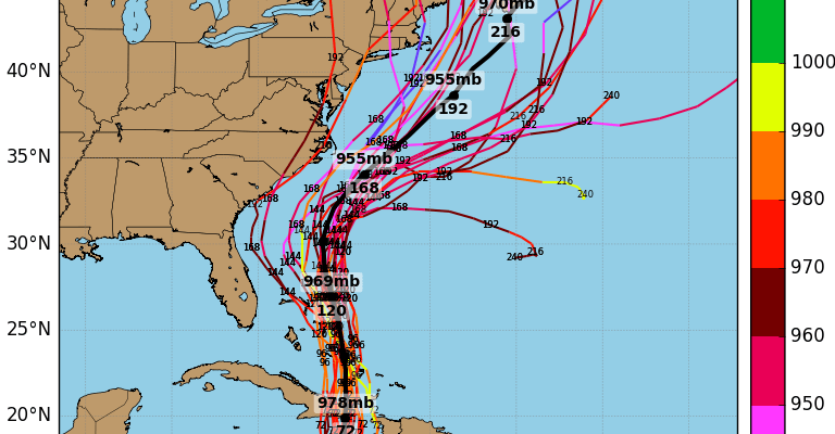
Overnight models seem to be showing a mostly out to sea solution for the east coast with the European model taking a sharp eastward turn. The GFS is furthest west and just offshore making this look almost like a winter type nor’easter moving up the coast. We have discussed all the keys to the forecast and it seems to boil down now to the system coming into the Plains and Rockies next week and whether it is deep enough to lift the hurricane northward instead of kicking it out northeastward. We will need to see more of course but we are beginning to get a sense of where this is all going.

When we look at the GFS ensembles overnight one important take away is that almost all of them have an offshore track.
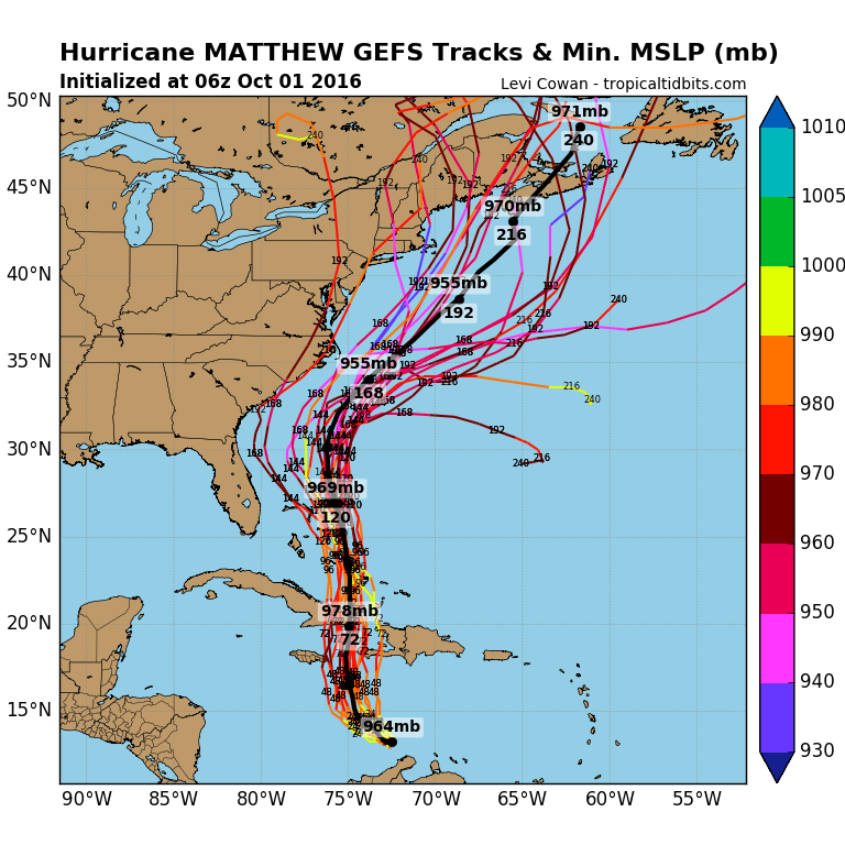
Only a couple of these models bring Hurricane Matthew close to the coast. Remember that we are still 7 days out and models have been especially volatile. We have been back and forth in both directions over the last few days. Swings going forward should be getting smaller and smaller.
WINTER WEATHER OUTLOOK VIDEOS
In case you missed them I’ve been previewing the upcoming winter in a series of posts and videos. Here are the first 2. More will be coming along. Links to the latest posts are below.
NEW JERSEY
LONG ISLAND AND NEARBY
WINTER 2016-2017 PART 3 NEW JERSEY
WINTER 2016-2017 PART 1 OCEAN WATER TEMPERATURES
WINTER 2016-2017 PART 2 ARCTIC SEA ICE AND SIBERIAN SNOW COVER
FiOS1 News Weather Forecast For Long Island
FiOS1 News Weather Forecast For New Jersey
FiOS1 News Weather Forecast For Hudson Valley
NATIONAL WEATHER SERVICE SNOW FORECASTS
LATEST JOESTRADAMUS ON THE LONG RANGE

Weather App

Don’t be without Meteorologist Joe Cioffi’s weather app. It is really a meteorologist app because you get my forecasts and my analysis and not some automated computer generated forecast based on the GFS model. This is why your app forecast changes every 6 hours. It is model driven with no human input at all. It gives you an icon, a temperature and no insight whatsoever.
It is a complete weather app to suit your forecast needs. All the weather information you need is right on your phone. Android or I-phone, use it to keep track of all the latest weather information and forecasts. This weather app is also free of advertising so you don’t have to worry about security issues with your device. An accurate forecast and no worries that your device is being compromised.
Use it in conjunction with my website and my facebook and twitter and you have complete weather coverage of all the latest weather and the long range outlook. The website has been redone and upgraded. Its easy to use and everything is archived so you can see how well Joe does or doesn’t do when it comes to forecasts and outlooks.
Just click on the google play button or the apple store button on the sidebar for my app which is on My Weather Concierge. Download the app for free. Subscribe to my forecasts on an ad free environment for just 99 cents a month.
Get my forecasts in the palm of your hand for less than the cost of a cup of Joe!

MENTION JOE CIOFFI AND GET A 5% DISCOUNT


