Hurricane Hector Category 4 140 MPH Hawaii Bound
Hurricane Hector Category 4 140 MPH Hawaii Bound

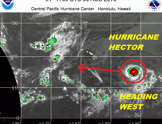
Hurricane Hector Category 4 is moving on a steadfast westerly course. The hurricane with 140 mph winds has not gained much latitude in spite of the weakness in the upper ridge to the north of the hurricane. The strengthening upper high north and northwest of Hawaii will likely keep Hector on a due west course. If this verifies Hector will pass safely south of the entire Hawaiian chain on Wednesday. It will likely weaken a bit as it goes by on Wednesday but it will still be a rather formidable category 2 hurricane as it passes to the south of the big island of Hawaii.

None of the hurricane tracking models or any of the global models bring Hector anywhere close to the Hawaiian Islands. The small size of the hurricane limits the northern extent of gales and rain. It appears that if models are correct, Hector’s impacts will be confined to the coastal waters.

You can read more on Hurricane Hector at Central Pacific Hurricane Center. Meanwhile in the Atlantic which remains quiet for the most part, we can see disturbed weather in the Central Atlantic showing some signs that the system is become more tropical in nature. Thunderstorms are developing closer to the low level circulation center that has been weak up until now. Development here is possible however the system is beginning to move slowly northeastward and it will be any threat even if does develop.
WIDE ATLANTIC TROPICAL SATELLITE

The Tropical Atlantic remains anemic with tropical waves moving westward but strong upper winds and Saharan dust continue to inhibit tropical storm formation in this area. Hostile upper air wind conditions continue across the Gulf of Mexico and the Caribbean with little change expected here this week.
WESTERN ATLANTIC TROPICAL SATELLITE

The Western Atlantic is also very quiet with very little going on here. An upper high is over the Southwest Atlantic and extends westward into the Gulf of Mexico.
Please consult your local National Weather Service office at weather.gov for the latest information on any tropical or storms or hurricanes that could be a threat to your area. Consult your local government officials regarding action you may need to take to secure life and property
FiOS1 News Weather Forecast For Long Island
FiOS1 News Weather Forecast For New Jersey
FiOS1 News Weather Forecast For Hudson Valley