HURRICANE FRANKLIN THE FIRST OF THE ATLANTIC SEASON
HURRICANE FRANKLIN THE FIRST OF THE ATLANTIC SEASON
Hurricane Franklin became the first hurricane of the Atlantic Season with top winds of 75 mph. This occurs on August 9th when on average we usually see the first hurricane of the season develop so it seems everything is behaving according to the calendar. Hurricane Franklin is tracking to the west and this motion will take it inland over Mexico overnight.

..FRANKLIN BECOMES THE FIRST HURRICANE OF THE 2017 ATLANTIC
SEASON…
SUMMARY OF 400 PM CDT…2100 UTC…INFORMATION
———————————————-
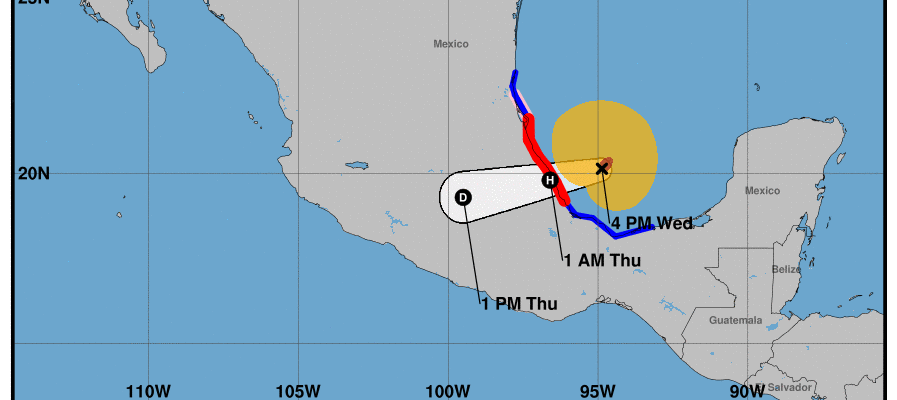
LOCATION…20.1N 94.9W
ABOUT 175 MI…280 KM ESE OF TUXPAN MEXICO
ABOUT 105 MI…170 KM NE OF VERACRUZ MEXICO
MAXIMUM SUSTAINED WINDS…75 MPH…120 KM/H
PRESENT MOVEMENT…W OR 270 DEGREES AT 12 MPH…19 KM/H
MINIMUM CENTRAL PRESSURE…984 MB…29.06 INCHES
WATCHES AND WARNINGS
——————–
CHANGES WITH THIS ADVISORY:
None.
SUMMARY OF WATCHES AND WARNINGS IN EFFECT:
A Hurricane Warning is in effect for…
* The coast of Mexico from Puerto de Veracruz to Cabo Rojo
A Hurricane Watch is in effect for…
* The coast of Mexico north of Cabo Rojo to Rio Panuco
A Tropical Storm Warning is in effect for…
* The coast of Mexico east of Puerto de Veracruz to Puerto Dos Bocas
* The coast of Mexico north of Tuxpan to Barra del Tordo
A Hurricane Warning means that hurricane conditions are expected
somewhere within the warning area. Preparations to protect life and
property should be rushed to completion.
A Hurricane Watch means that hurricane conditions are possible
within the watch area.
A Tropical Storm Warning means that tropical storm conditions are
expected somewhere within the warning area.
For storm information specific to your area, please monitor
products issued by your national meteorological service.
DISCUSSION AND 48-HOUR OUTLOOK
——————————
At 400 PM CDT (2100 UTC), the center of Hurricane Franklin was
located near latitude 20.1 North, longitude 94.9 West. Franklin is
moving toward the west near 12 mph (19 km/h), and this general
motion is expected to continue for the next day or so. On the
forecast track, the center of Franklin is expected to cross the
coast in the Mexican state of Veracruz tonight or early Thursday.
Maximum sustained winds have increased to near 75 mph (120 km/h)
with higher gusts. Some additional strengthening is expected until
the center crosses the coast. Rapid weakening is expected after
landfall in Mexico.
Hurricane-force winds extend outward up to 35 miles (55 km) from the
center and tropical-storm-force winds extend outward up to 140 miles
(220 km).
The estimated minimum central pressure is 984 mb (29.06 inches).


Elsewhere in the tropics we still have the tropical wave in the Atlantic northeast of the Leeward Islands moving west northwestward. Clouds and showers have flared up this afternoon and conditions are forecast to become more conducive for development over the next 5 days. Also we have disturbed weather over the Bahamas that is disorganized and not expected to develop anytime soon.
MANY THANKS TO TROPICAL TIDBITS FOR THE WONDERFUL USE OF THE MAPS
Weather App

Don’t be without Meteorologist Joe Cioffi’s weather app. It is really a meteorologist app because you get my forecasts and my analysis and not some automated computer generated forecast based on the GFS model. This is why your app forecast changes every 6 hours. It is model driven with no human input at all. It gives you an icon, a temperature and no insight whatsoever.
It is a complete weather app to suit your forecast needs. All the weather information you need is right on your phone. Android or I-phone, use it to keep track of all the latest weather information and forecasts. This weather app is also free of advertising so you don’t have to worry about security issues with your device. An accurate forecast and no worries that your device is being compromised.
Use it in conjunction with my website and my facebook and twitter and you have complete weather coverage of all the latest weather and the long range outlook. The website has been redone and upgraded. Its easy to use and everything is archived so you can see how well Joe does or doesn’t do when it comes to forecasts and outlooks.
Just click on the google play button or the apple store button on the sidebar for my app which is on My Weather Concierge. Download the app for free. Subscribe to my forecasts on an ad free environment for just 99 cents a month.
Get my forecasts in the palm of your hand for less than the cost of a cup of Joe!