
Low Humidity Continues Thursday Plus Weekend Outlook
Low Humidity Continues Thursday Plus Weekend Outlook
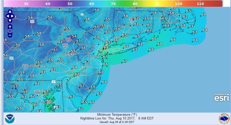
A beautiful day has come to an end and now another good night for sleeping with low humidity and reasonable temperatures as lows by Thursday morning will be mostly in the upper 50s to mid 60s. It is a few degrees higher than then the Wednesday morning lows but the humidity remains reasonable which is is a good thing.
Low humidity continues on Thursday with another day of sunshine and temperatures in the range of 80 to 85. Back to back days of low humidity and sunshine in early August is always a good thing. The satellite loop tonight shows dry clear skies and that will hold all night long and of course sunshine rules all day Thursday.
SATELLITE LOOP

REGIONAL RADAR

LOCAL RADAR NEW YORK CITY

LOCAL RADAR PHILADELPHIA


A couple of changes for the Friday and the weekend that you might like. First is that Friday while more humid won’t be that uncomfortable with a mix of sun and clouds with highs in the upper 70s to mid 80s thanks to an onshore flow. Im not mentioning any showers for Friday or Friday evening. The next cold front is a little faster and a little weaker so we should have clouds and sun warm and humid conditions Saturday with the risk for scattered afternoon or evening thunderstorms in some places. Highs will be in the low to mid 80s. Then the front passes and we should have another shot of dry air pushing in for Sunday. Sunday may wind up being warmer than Saturday with more sun and a northwest wind so highs Sunday could reach the mid to upper 80s. However no rain is forecast for Sunday. We may have to save it for Monday though if the front sags far enough south, we could wind up with some sunshine instead.
 GET JOE A CIGAR IF YOU LIKE

LANDSCAPE COMPANIES FOR YOUR NEEDS
LONG ISLAND ROCKLAND COUNTY Connecticut

![]()

ROCKLAND COUNTY TRI STATE SNOW REMOVAL JOHNSTOWN PA


FiOS1 News Weather Forecast For Long Island
FiOS1 News Weather Forecast For New Jersey
FiOS1 News Weather Forecast For Hudson Valley


