
Hot Thunderstorms 90-95 Degrees
Hot Thunderstorms 90-95 Degrees
Hottest Day of Summer So Far
Thunderstorms Possible PM
Today may very well turn out to be the hottest day of the month so far and the hottest of the summer so far area wide. Everyone should get into the 90s and highs could reach 90 to 95 in most places. When we look 8am temperatures it is already in the mid to upper 80s in some places!
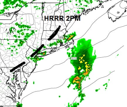
Hot Thunderstorms 90-95 Degrees Today’s Highs

Hot Thunderstorms 90-95 Degrees 8AM Temperatures
CITY           SKY/WX    TMP DP  RH WIND       PRES   REMARKS
CENTRAL PARK   SUNNY     83  70  64 CALM      29.91R
LAGUARDIA APRT MOSUNNY   86  69  56 W3        29.87R HX  90
KENNEDY INTL   MOSUNNY   86  72  62 SW7       29.89R HX  92
NEWARK/LIBERTY MOSUNNY   87  70  56 NW6       29.88R HX  92
BRNX BOT. GARD   N/A     84  68  58 W1        29.89S
TETERBORO      SUNNY     86  68  54 CALM      29.87R
$$

NYZ177-179-078>081-151400-
LONG ISLAND NEW YORK

CITY           SKY/WX    TMP DP  RH WIND       PRES   REMARKS
FARMINGDALE    SUNNY     86  71  60 NW6       29.89R HX  91
ISLIP          MOSUNNY   87  72  60 NW6       29.88R HX  93
SHIRLEY        SUNNY     86  72  62 W6        29.89R HX  92
RIVERHEAD        N/A     84  75  74 CALM      29.87R HX  92
WESTHAMPTON    SUNNY     85  73  67 SW5       29.90R HX  91
SOUTHAMPTON      N/A     75  73  94 SW5       29.85R
BRIDGEHAMPTON    N/A     81  75  83 CALM      29.73R
EAST HAMPTON   FAIR      83  74  72 W5        29.88R HX  90
MONTAUK POINT    N/A     81  74  79 SW5       29.89R
$$

NYZ052-065-067-151400-
HUDSON VALLEY

CITY           SKY/WX    TMP DP  RH WIND       PRES   REMARKS
WHITE PLAINS   SUNNY     83  70  64 NW7       29.89R
NEWBURGH       MOSUNNY   79  72  78 W9        29.91R
MONTGOMERY     MOSUNNY   81  70  69 CALM      29.89R
POUGHKEEPSIE   MOSUNNY   82  69  64 VRB3      29.87S
ALBANY         PTSUNNY   80  66  62 W7        29.87R
$$

NJZ001-105-106-008-010-013-015-019>022-104-151400-
NEW JERSEY

CITY           SKY/WX    TMP DP  RH WIND       PRES   REMARKS
NEWARK/LIBERTY MOSUNNY   87  70  56 NW6       29.88R HX  92
TETERBORO      SUNNY     86  68  54 CALM      29.87R
CALDWELL       SUNNY     83  70  64 W5        29.89S
MORRISTOWN     MOSUNNY   82  72  69 CALM      29.89S
SOMERVILLE     SUNNY     84  70  62 W3        29.88R
SUSSEX         LGT RAIN  79  72  79 SW3       29.90S
ANDOVER          N/A     78  70  76 SW3       29.92R
TRENTON        SUNNY     83  70  64 NW6       29.90R
MILLVILLE      SUNNY     84  71  65 W9        29.92S
ATLANTIC CITY    N/A    N/A N/A N/A MISG      29.92R
WRIGHTSTOWN    SUNNY     85  71  63 NW9       29.88R HX  90
TOMS RIVER     SUNNY     84  72  65 W8        29.91R
BELMAR         SUNNY     85  73  67 W9        29.91S HX  91
$$

PAZ047>061-062-071-151400-
EASTERN PENNSYLVANIA

CITY           SKY/WX    TMP DP  RH WIND       PRES   REMARKS
PHILADELPHIA   MOSUNNY   84  68  58 W8        29.91R
ALLENTOWN      CLOUDY    79  68  69 SW6       29.92R
SCRANTON       PTSUNNY   77  67  71 SW8       29.93R
$$

CTZ002-004>006-009-010-012-RIZ004-006-007-MAZ004-011-015-151400-
SOUTHERN NEW ENGLAND
 IN CT

CITY           SKY/WX    TMP DP  RH WIND       PRES   REMARKS
BRADLEY INTL   MOSUNNY   81  71  71 CALM      29.87R
HARTFORD       SUNNY     82  74  76 CALM      29.87R
DANBURY        SUNNY     81  71  71 SW6       29.90S
WTRBRY/OXFORD  MOSUNNY   79  70  73 NW5       29.92R
BRIDGEPORT     SUNNY     82  73  74 SW6       29.87R
MERIDEN        SUNNY     82  72  71 CALM      29.88R
NEW HAVEN      SUNNY     79  73  82 CALM      29.87R
CHESTER        FAIR      82  72  69 NW3       29.89S
GROTON         SUNNY     77  77 100 S6        29.87R
WILLIMANTIC    NOT AVBL

 IN RI
The dew points are still very high and the HRRR model and others shows a dry line to the north. Now what may happen is that along and south of the dry line, some thunderstorms will develop this afternoon. They look to be scattered and sometimes in cases like this they could get strong under the right conditions so be aware of this.


Now as far as tonight and the weekend, weather conditions improve tonight with lows in the mid 60s to lower 70s. Saturday and Sunday look good to me with no worse than partly sunny skies. Highs will be in the upper 80s to low 90s on Saturday and 80s to near 90 on Sunday.
We will of course update you on any thunderstorm developments with live broadcasts on facebook and twitter.
FiOS1 News Weather Forecast For Long Island
FiOS1 News Weather Forecast For New Jersey
FiOS1 News Weather Forecast For Hudson Valley
NATIONAL WEATHER SERVICE SNOW FORECASTS
LATEST JOESTRADAMUS ON THE LONG RANGE
Weather App

Don’t be without Meteorologist Joe Cioffi’s weather app. It is really a meteorologist app because you get my forecasts and my analysis and not some automated computer generated forecast based on the GFS model. This is why your app forecast changes every 6 hours. It is model driven with no human input at all. It gives you an icon, a temperature and no insight whatsoever.
It is a complete weather app to suit your forecast needs. All the weather information you need is right on your phone. Android or I-phone, use it to keep track of all the latest weather information and forecasts. This weather app is also free of advertising so you don’t have to worry about security issues with your device. An accurate forecast and no worries that your device is being compromised.
Use it in conjunction with my website and my facebook and twitter and you have complete weather coverage of all the latest weather and the long range outlook. The website has been redone and upgraded. Its easy to use and everything is archived so you can see how well Joe does or doesn’t do when it comes to forecasts and outlooks.
Just click on the google play button or the apple store button on the sidebar for my app which is on My Weather Concierge. Download the app for free. Subscribe to my forecasts on an ad free environment for just 99 cents a month.
Get my forecasts in the palm of your hand for less than the cost of a cup of Joe!
![]()

MENTION JOE CIOFFI AND GET A 5% DISCOUNT


