Severe Weather Ends Hot Friday
Severe Weather Ends Hot Friday
This afternoon and early evening round of severe weather is over with. We will spend the rest of the night with improving weather conditions with leftover clouds. Thunderstorms are moving across Central and Northern New England this evening. To our west and south there is very little to worry about for tonight or for much of Friday. There are some strong cells in Central Connecticut moving to the east but these storms should continue to weaken as we move through the night.
Severe Weather Ends Hot Friday
Radar Loops


Friday & Weekend Outlook
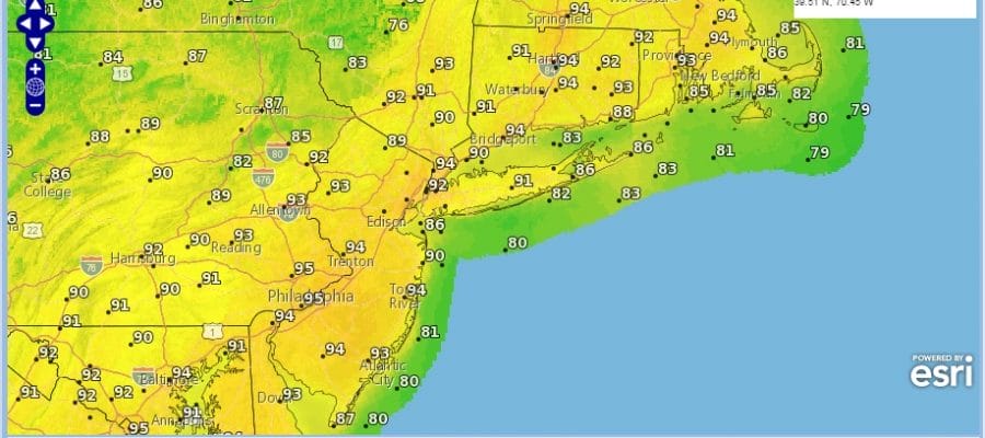
Friday is shaping up to be a hot day with sunshine and a few clouds. Temperatures are going to take off on a northwest wind. Highs will reach 90 to 95 everywhere including the shore. The only issue will be late in the afternoon and evening as some thunderstorms could develop.
FRIDAY FORECAST HIGHS

FRIDAY FORECAST DEW POINTS
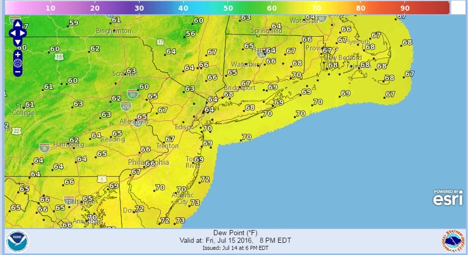
The problem Friday is that the lower dewpoints and the dry air are sitting just to the north of the area and this could set up a zone where thunderstorms develop south of the dry line. That line will set up somewhere in the Lower Hudson Valley and Northern New Jersey. Those thunderstorms should they develop will come later in the afternoon and evening. I would not be surprised if some isolated storms grow strong.
The weekend remains okay in my view with a mix of sun and clouds and highs in the 80s both days. Some spots on Saturday in New Jersey could hit 90. I don’t by the NAM idea of rain or showers Saturday afternoon and night. Other models are dry and that’s the way I’m leaning.
FiOS1 News Weather Forecast For Long Island
FiOS1 News Weather Forecast For New Jersey
FiOS1 News Weather Forecast For Hudson Valley
NATIONAL WEATHER SERVICE SNOW FORECASTS
LATEST JOESTRADAMUS ON THE LONG RANGE
Weather App

Don’t be without Meteorologist Joe Cioffi’s weather app. It is really a meteorologist app because you get my forecasts and my analysis and not some automated computer generated forecast based on the GFS model. This is why your app forecast changes every 6 hours. It is model driven with no human input at all. It gives you an icon, a temperature and no insight whatsoever.
It is a complete weather app to suit your forecast needs. All the weather information you need is right on your phone. Android or I-phone, use it to keep track of all the latest weather information and forecasts. This weather app is also free of advertising so you don’t have to worry about security issues with your device. An accurate forecast and no worries that your device is being compromised.
Use it in conjunction with my website and my facebook and twitter and you have complete weather coverage of all the latest weather and the long range outlook. The website has been redone and upgraded. Its easy to use and everything is archived so you can see how well Joe does or doesn’t do when it comes to forecasts and outlooks.
Just click on the google play button or the apple store button on the sidebar for my app which is on My Weather Concierge. Download the app for free. Subscribe to my forecasts on an ad free environment for just 99 cents a month.
Get my forecasts in the palm of your hand for less than the cost of a cup of Joe!

MENTION JOE CIOFFI AND GET A 5% DISCOUNT


